In
ter
nat
ion
al J
ou
rn
al o
f
A
sia
n-P
aci
fic H
erit
ag
e S
tud
ies
Government Publication Registration Number
11-1550215-000040-10
Sustainable
Conservation of
Cultural
Heritage
International Journal
of Asian-Pacif i c
Heritage Studies
Su
sta
in
ab
le C
on
ser
vat
ion o
f C
ult
ura
l H
erit
ag
e

Sustainable
Conservation of
Cultural
Heritage
International Journal
of Asian-Pacific
Heritage Studies

Contents

Material Science Analysis of Lacquer for Traditional Repair of Stones
006
in Cambodia
Jiyoung Kim, Seonhye Jeong, Jia Yu, Yongjae Chung
Development of Photogrammetry Education Program
034
for 3D Digital Scan of Cultural Heritage
Jong-wook Lee, Bo-ram Kim, Seon-mi Kim
01
Survey Research Papers on Materials and Techniques
in the UNESCO Chair Programme
Survey Research Papers on UNESCO Chair Research Grant
The 'Sense of Place' Creation through Cultural and Architectural
070
Preservation of Timber Construction of Malay Mosque Architecture
Case Study: Chepor Raja Mosque, Lenggong, Perak, Malaysia
Azizi Bahauddin, Mohd Jaki Mamat
Investigating the Significance of Toponym to the Outstanding
086
Local Values of Heritage Places for the City’s Cultural and
Economic Competitiveness
Eko Nursanty
Preservation and Historical Study of Early Architectural Drawings
100
and Pictorial Records of Heritage Buildings in Seremban, Malaysia
Kum Weng Yong, Doris Hooi Chyee Toe
Outstanding Universal Value of George Town, Penang:
124
Surviving Covid-19
Lim Yoke Mui, Khoo Suet Leng
Trace Relationship between Revered River and Sacred Settlements
158
Morphology in South India: Case of Kaveri River
in Context of South Karnataka
Monalisa Bhardwaj, Sudha Kumari G
Traditional Use of Lacquer in Cambodia
180
Vanna LY
02

01

Survey Research Papers on
Materials and Techniques
in the UNESCO Chair Programme
Material Science Analysis of Lacquer for Traditional Repair of Stones in Cambodia
Jiyoung Kim, Seonhye Jeong, Jia Yu, Yongjae Chung
Development of Photogrammetry Education Program
for 3D Digital Scan of Cultural Heritage
Jong-wook Lee, Bo-ram Kim, Seon-mi Kim

Jiyoung Kim Research Professor, KNUCH Industrial Educational Association
Seonhye Jeong Researcher, KNUCH Industrial Educational Association
Jia Yu Researcher, National Research Institute of Cultural Heritage
Yongjae Chung Professor, KNUCH
Material Science Analysis of Lacquer for
Traditional Repair of Stones in Cambodia
Cambodia has been producing various crafts and functional materials
using lacquers since ancient times. Compared to its neighboring countries
of Myanmar and Vietnam, Cambodian traditional lacquers have received
less attention despite their extensive use and long history. This study aims to
evaluate the potential of lacquer as an important material for repairing cultural
properties, and examines its various uses in making and repairing stone
statues in Cambodia. To gather basic data, the composition and characteristics
of lacquer utilized during the ancient times were analyzed scientifically. The
study confirmed that Cambodian lacquer mortar was used as adhesives, fillers,
and finishing materials in the repair of stone statues before the development
of modern synthetic resins. Furthermore, the adhesive lacquer was made of
almost pure lacquer without any inorganic additives, and the filling lacquer
mortar was manufactured by adding a large amount of soil and bone fragments
to the lacquer. The results obtained can provide valuable insights to help revive
the traditional techniques that have been forgotten and to develop technologies
that can be used in the repair of modern stone heritage statues in Cambodia.
Abstract
Survey Research Papers on Materials and Techniques in the UNESCO Chair Programme
01

Jiy
oung Kim
7
1. Background and research aims
Heritage stone statues in Cambodia's Angkor ruins (9th to 14th centuries) have
been worshiped and revered by locals as religious and cultural objects since
their creation. They have been repaired and restored several times after being
destroyed either by changes in social and religious ideology or after natural
damage incurred due to prolonged usage and weathering. Hindu and Buddhist
stone statues found in the ruins were extensively destroyed for religious reasons
and were further damaged by the civil war. Lacquer was extensively used to
restore the damaged stone statues, especially for binding the fallen heads or
arms of the stone statues or for filling in the missing parts. Lacquer comes in
various colors, lusters, and surface textures depending on the mixing ratio of
various organic and inorganic substances which can be altered as per the usage
requirements.
The use of lacquer is confirmed after analyzing the artifacts; however, no
record or data exists on its manufacturing process or the time of its application.
Furthermore, little research has been conducted on the Cambodian lacquer
mortar—hence, it is quite difficult to find information on the traditional lacquer
technology. This research aims to obtain the basic information needed to restore
the traditional lacquer technology by scientifically analyzing the lacquer products
used in the repair and restoration of the stone statues from the ruins of Angkor,
Cambodia.
2. Object and method
Stone Buddha statues from the Thousand Buddha Gallery at Angkor Wat
and the Pre Rup Temple within the Angkor Archaeological Park were selected
as research subjects. Angkor Wat is located to the south of Angkor Thom and
Pre Rup to the east (Figure 1). Reparation of stone Buddha statues using lacquer
is undertaken at the Thousand Buddha Gallery in Angkor Wat. The Pre Rup
Temple is a Hindu temple dedicated to Shiva. It dates to the 10th century and is
still revered as a sacred place of worship by the residents nearby. There are two
stone statues of Kor and Gor in the central sanctuary, many parts of which have
been restored using the lacquer mortar. The Pre Rup stone statues particularly
showcase various types of lacquer mortar. Preservation treatment performed in
2019 allowed for samples to be collected for further analysis.
The types of lacquer materials identified by naked-eye observation were
classified into adhesives, surface finishing, bonding filling, and molding
restoration. Their macroscopic characteristics were differentiated by type in
Ⅰ
. Introduction

8
detail so that the microstructural characterization and qualitative analytical
methods could be conducted. To determine the additive materials while
manufacturing the lacquer mortar, characteristics such as color, luster, and
hardness were investigated through visual observation, whereas microscopic
observation was performed to identify microstructures and components that
could not be confirmed macroscopically.
Polarized microscopic, stereoscopic microscopic, and scanning electron
microscopic analyses were performed on the lacquer mortar samples collected
Figure 2. Location of Angkor Wat and Pre Rup temples
Figure 1. Location of Siem Reap, Cambodia
Jiy
oung Kim
9
from two stone statues in the Pre Rup Temple sanctuary which permitted
sample collection. Additionally, X-ray diffraction analysis and SEM-EDS analysis
were conducted to identify its mineral and chemical composition respectively.
Pyro-GC and FT-IR analyses were performed to analyze the organic matter.
Table 1. Analytical methods
Category
Content
Macroscopy
Color, luster, hardness
Microscopy
Polarizing, stereoscopic, and electronic microscopic analysis
Qualitative analysis
XRD, SEM-EDS, FT-IR, Py-GC/MS
1. Current status
Cambodians have used lacquer to create small objects. Lacquer was
applied to the surface of base materials such as wood, bamboo, earthenware,
ceramics, paper, metal, and leather and was used for finishing, waterproofing,
and decoration purposes. Lacquer has been applied to stone statues from
the pre-Angkor period and became a universal decorative technique during
the Angkor period. Interestingly, lacquer has also been used to repair stone
statues as evident in those found in the Thousand Buddhas Gallery, Angkor Wat.
Lacquer was used to bind broken heads and arms of the stone statues. Iron rods
and bands were also added to reinforce their mechanical strength—a practice
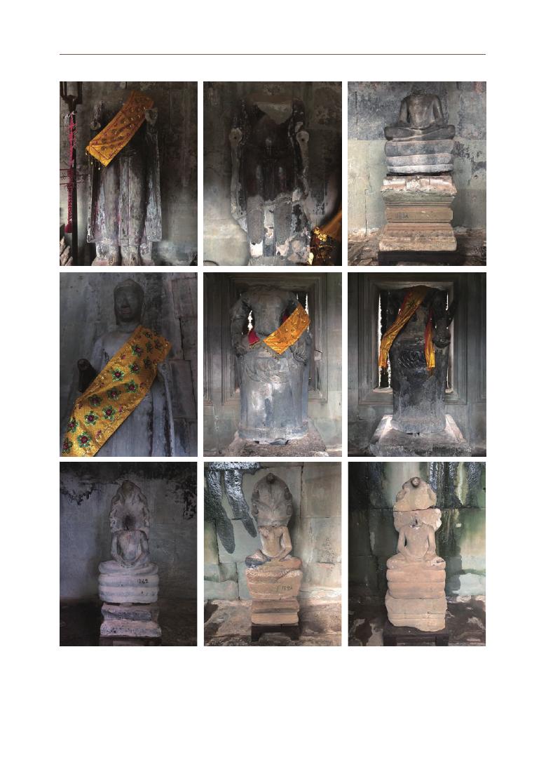
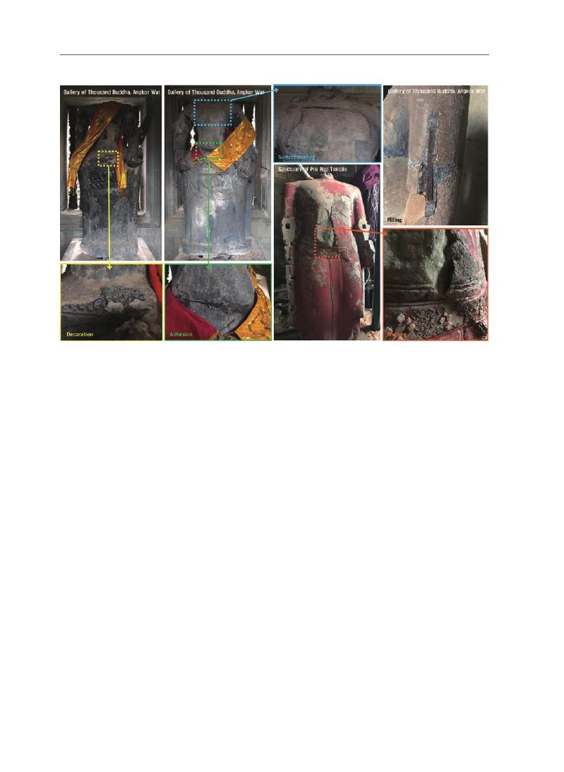
perhaps adopted from the 19th to the early 20th century (Figure 3).
A similar case was observed at the Pre Rup temple. This temple is located
south of East Baray, along with the East Mebon Temple on the north-south axis.
Rajendravarman II (944–968 AD) is assumed to have built it as a Hindu temple
devoted to Shiva either in 1961 or early 1962. The name of the temple means
"
turn the body," hence it is presumed that it might have served as a crematorium,
In the central sanctuary of the temple, there are two Buddhist-style stone
statues called Gor and Kor, which are presumed to have been moved from the
temple of Prasat Bat Chum which is only 1.8 km away from Pre Rup (Figure 4).
These stone statues are considered sacred by the locals and are still handed
down as objects of worship. There are several traces of reparations. The head
has disappeared, and a red pigment covers its surface, and in the case of Kor,
the gorgeous waist decoration remains intact. It appears to have been painted
with a red pigment after lacquer was applied to the entire surface of the stone
statue. It is presumed that lacquer was also used to attach the waist decoration.
Ⅱ
. Current status
and previous
studies
10
Figure 3. Case of lacquered stone statues located in the Angkor Wat 1000 Buddhas Gallery at Angkok Wat
Jiy
oung Kim
11
Figure 4. Stone statues located in the central sanctuary of Pre Rup (left: Gor, right: Kor)
Figure 5. A stone statue located around the library in Phnom Bakheng
Figure 6. Case of stone statues lacquered and painted in the National Museum of
Cambodia. Buddha on Naga/Angkor period-Angkor wat style(left); Head of
Divinity/Angkor period-Bayon style(center); Bas-relief/Post Angkor period(right)
12
Figure 7. Case of stone statue repair using lacquer
Estimated to have been built during the reign of Yasovarman at the end of
the 9th century, Phnom Bakheng Temple was built two centuries earlier than
Angkor Wat was. Two libraries are located on the east side of Phnom Bakheng,
and stone statues are enshrined inside and around the library located in the
south. Only one stone statue with lacquer, gold leaf, and red pigment remains.
The remaining form suggests that the stone was lacquered, painted with red
pigment, and then covered with gold leaf. The production form is similar to the
stone statues of Pre Rup (Figure 5).
Apart from the stone statues located within the ruins, the National Museum
of Cambodia also possesses a large collection of stone statues with lacquered
remains. Upon searching for sandstone in the inventory of the museum’s
collection system, thirteen stone statues were identified with clear traces of
pigments, gold leaf, and lacquer. The main production periods for these stone
statues are the Angkor period (Angkor Wat style, Bayon style) and the post-Angkor
period (Figure 6).
Lacquer can be used for bonding, filling, and surface finishing while repairing
the stone statues as can be observed in the two stone statues located in the Pre
Rup. Bonding and surface finishing lend a glossy and dense appearance and
looks brown in color. The lacquer used for filling a lost part of the statue appears
gray in color and contains small particles accounting for its high additive content
(
Figure 7).

Jiy
oung Kim
13
2. Previous studies and cases
Research conducted in the last five years was reviewed to confirm the
domestic research trends related to lacquers and the method for scientific
analysis of the material of the statues. Research on lacquers can be classified
into the scientific analysis of the material of the excavated artifacts (focused
on lacquer layer),
research on lacquer craft techniques (mainly lacquerware), and
research on lacquer application for utilizing it as a coating material. The scientific
analysis of the material of the excavated artifacts made of wood lacquer was
conducted as follows: organic materials such as lacquer were analyzed using
FT-IR (Fourier Transform Infrared Spectroscopy) and Py-GC/MS (Pyrolysis/GC/MS);
and inorganic materials such as soil powder were analyzed using EDX (Energy
Dispersive X-ray Spectroscopy)
analysis after observation with an optical microscope
and SEM (Scanning Electron Microscope).
Various analytical methods confirmed in previous studies were applied
to Cambodian lacquer samples. The lacquer craft techniques were reviewed
through the literature available on it which was then compared with the craft
techniques for the currently handed down artifacts. A significant portion of the
research on craft techniques was focused on the “mother-of-pearl” technique
handed down to the current artisans. Research reflects that the application of
lacquer to various objects depends on its waterproofing ability, the firmness of
the coating film, and its excellent adhesion ability and that its intended use as a
natural material.
The first Cambodian sculptures were produced in the Kingdom of Funan (2nd
– 6th century)
located in the Mekong Delta. Considered as the cradle of the Khmer
civilization, the first sites with carvings and statues of Indian-style footprints
were discovered here. From the 7th century onwards began the development of
the unique style and craftsmanship of Khmer sculptures. Sculpture continued to
develop in this area and later reached the climax of Angkor sculpture.
At the beginning of the 10th century, Yasovarman I moved the capital of
the Kingdom from Hariharalaya to Angkor. Over a thousand temples and
sanctuaries were built by succeeding kings of the capital between the 9th and
13th centuries owing to the region’s abundant rocks and soil rich. Sculpture-
making peaked in the 12th century, the splendid period of the Khmer Empire.
With the fall of the Khmer Empire, stone carving work became less advanced,
and over time the material was replaced by wood. This was a result of the large-
scale conversions of the locals from Hindu to Theravada in the 15th century.
Since then, lacquer or huge panels have been produced to decorate the wooden
14
sculptures, and the scenes depicting Cambodian culture and history have been
mainly produced there.
Woodwork was centered in Battambang. Cambodian sculptural craft based
on wood or stone almost disappeared during the Khmer Rouge period. During
the period from 1975 to 1979, most of the artisans were persecuted or forced
to farm or earthwork. Since 1992, with the efforts of the European Union and
NGOs, the training and education of young Cambodians have begun to revive the
ancient Cambodian arts and techniques.
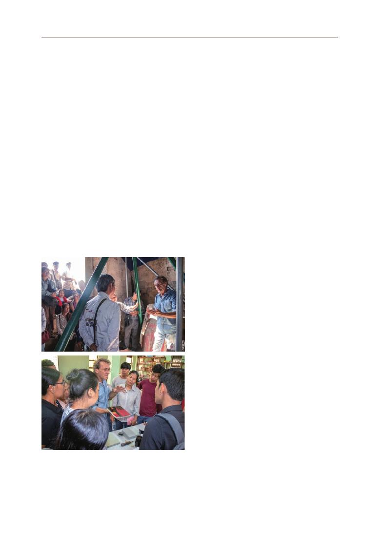
Two stone statues of Pre Rup have been analyzed for conservation from
2018. It was carried out at the SCU (Stone Conservation Unit) which has for long
overseen the preservation and restoration of stone heritage in the Angkor site.
The two stone statues are covered with faint traces of gold leaf and ornaments,
lacquer, and pigments. Prior to conservation, an educational workshop on the
material of the stone statue was held on July 5, 2018. Thirty experts in the field of
stone conservation and archaeology from APSARA (Authority for the Protection of the
Site and Management of the Region of Angkor)
and ACO (Angkor Conservation Office) and GIZ
(
Deutsche Gesellschaft für Internationale Zusammenarbeit)
held a workshop on traditional Cambodian lacquer
and its application.
Participants visited the site of Pre Rup and
discussed the lacquers on the Buddha statue.
Lectures were then delivered on the history of
lacquer, traditional methods of harvesting and
processing, and methods of using materials in
Southeast Asia. Finally, practicals was carried out
and lacquer sampling methods were conducted
based on the theoretical lecture delivered earlier
(
Figure 8).
Under the leadership of GIZ and SCU,
the conservation work of the two Pre Rup stone
statues was completed, and the results were
reported at the 35th Technical Session of the ICC-
Angkor on January 26, 2021. The results reflected
that lacquer was used to fill the cracks in the
statue.
Figure 8. Lecture on Cambodian traditional lacquer
(
source: GIZ)
Jiy
oung Kim
15
Figure 9. Dominant lacquer tree species by region in Asia
1. General characteristics of lacquer
Lacquer is a natural resin/oil-based paint containing catechol compounds,
water, polysaccharides, glycoproteins, and enzymes. The lacquer sap forms a
coating layer (film) via self-polymerization. The lacquer layer is a polymer that is
polymerized by laccase and does not dissolve in various organic solvents. As this
enzymatic reaction is required, it is important to maintain a temperature and
humidity of 25~28 ℃ and 70~80 % when drying the coating layer.
Lacquer is collected from the lacquer tree and used in the form of sap.
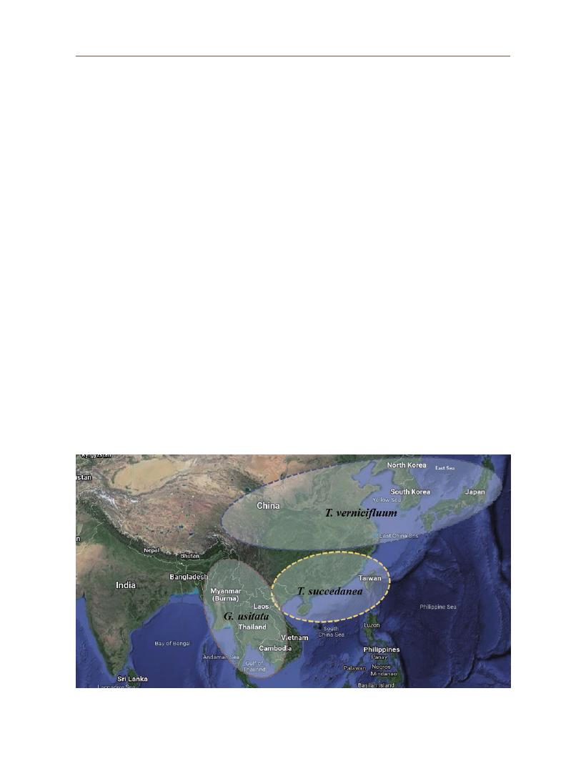
There are three types of lacquer trees.
Toxicodendron vernicifluum grown in
Korea, Japan, and China has a major lipid component of urushiol (C15), and
Toxicodendron succedanea grown in Vietnam and Taiwan has a major lipid
component of laccol (C17).
Gluta usitata, the main lipid component of which is
thitsiol (C17), is grown in Myanmar, Thailand, Laos, and Cambodia. In the case of
the Cambodian lacquer tree, Gluta laccifera is the main lipid component (Figure. 9).
Laccol (T. succedanea) and thitsiol (G. usitata, G. laccifera)-based lacquer sap
contain catechol that, when combined with skin proteins, can trigger an immune
system response (allergic reaction). Lacquer sap is a water-in-oil emulsion. Its
aqueous phase consists of water (20–30%), polysaccharides (5–6%), and laccase
enzyme (~1%), while the oil phase consists of catechol derivatives (60~70%) and
glycoproteins (2–3%).
Ⅲ. Characteristics
of the lacquer
sap and mortar

16
2. Characteristics of functional lacquer
The Cambodian lacquer mortar is a functional lacquer that has been
given plasticity by adding various additives to the lacquer sap. This functional
lacquer has also been traditionally manufactured and used in Northeast Asia,
Korea, China, and Japan. It was called ‘Golhoe’ (bone ash or bone powder). Golhoe
is sometimes called “Tohoe” (clay ash or clay powder), as bone powder was the
main additive in the traditional era. It has been substituted by soil powder in
the modern era. Golhoe was originally used as a filler to prevent deformation
of core shape and to fill gaps in the base material. To make wood lacquerware,
bulky material high in plasticity was needed to fill large gaps in the wooden core
structure. Therefore, various organic and inorganic materials were added to the
lacquer sap. Golhoe was not only widely used to produce wood lacquerware in
Korea, China, and Japan, but also in Nakrang.
Today, golhoe is generally made by mixing soil powder and fresh lacquer sap
in a 1:1 ratio. Other components added to it include bone powder, soil powder,
roof tile powder, animal extracts (animal glue, fish glue, etc.), and vegetable materials
(
tree resin, etc.).
Bone powder, soil powder, and roof tile powder give volume to
the material, especially bone powder and roof tile powder (or pottery powder) as
they are porous which allows lacquer sap to penetrate them. This makes golhoe
dense and more concentrated.
The color of lacquer mortar varies slightly depending on the materials
mixed. It is usually dark brown or dark black. However, when soil powder is
added to it, the red color becomes deeper, and when wood powder or roof tile
powder is added, it takes on a grayish color. Additionally, when the charcoal
powder is mixed, it becomes dark black.1
Lacquer mortar has different workability and properties depending on the
added material. Adding shellfish powder to lacquer decreases its strength,
whereas adding animal bones increases it. For the lacquer mortar to have
excellent adhesive strength, porous material is added to it. In modern lacquer
crafts, it is difficult to supply bone powder or roof tile powder; therefore, coral is
used sometimes.
The adhesion of lacquer mortar is not only determined by the added material
but also by the quality of the lacquer sap itself. The quality of lacquer sap
depends on whether the main components are urushiol, laccol, or thitsiol. Even
for the trees of the same species grown in the same region, the quality varies
greatly depending on the soil and in-situ environment. Therefore, it is necessary
for a person to determine the quality after collecting lacquer sap.
1 Eunjeong Jang, Junghae
Part, Soochul Kim, A Study
on Conservation Materials
of the Lacquer Wares : the
Tohoe and Goksu, Journal of
conservation science, 31(2),
2015.

Jiy
oung Kim
17
Another important factor affecting adhesion is the curing process of lacquer.
While bonding two materials, lacquer is first applied to the surface of one
substrate after which hardening begins. The best adhesive effect can be obtained
by attaching the rest of the pieces at the most appropriate time. This appropriate
time in the curing process is mostly determined by the knowledge and expertise
acquired by the craftsman. Additionally, the supply of water vapor plays an
important role in the curing process of lacquer. If a thick layer of lacquer mortar
is applied, the water vapor does not penetrate sufficiently into the sap; therefore,
the curing process is incomplete, and the adhesive strength is weakened.
As an adhesive, lacquer is usually prepared by mixing starch glue with it.
Lacquer adhesive prepared using barley glue is called Magpul which is used
for bonding pottery.2 The higher the mixing ratio of starch glue, the higher the
viscosity of the lacquer adhesive. There are only a few instances of using lacquer
as an adhesive for stones. Only Goguryeo murals feature a layer of raw lacquer
applied to the stone surface followed by laying on the pigment. In this case, even
when the raw lacquer was directly applied to the stone, a thin and homogeneous
film was produced with good adhesion. The excellent adhesive properties
of such lacquer were also confirmed during the reproduction experiment of
lacquer paintings on granite stones.3
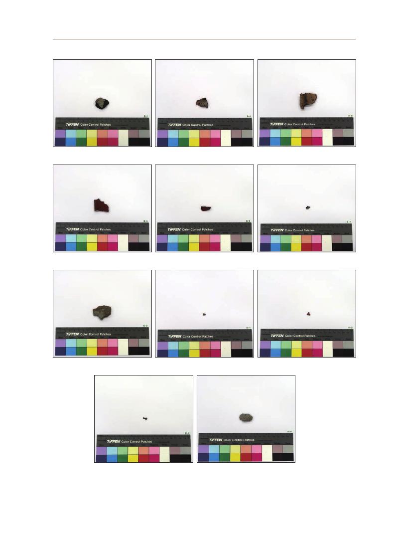
1. Sample selection and macroscopic characteristics
Cambodian lacquer mortar is gray, dark brown, or black. The diversity in
color is determined by the type and composition of the material mixed into it,
such as bone ash in Korea. Black lacquer mortar has a homogeneous color and
texture; therefore, it is presumed that it contains almost no additives or is mixed
with pulverized additives in small quantities. Consequently, gray and dark brown
lacquer mortars have various colored particles added to them in various sizes
(
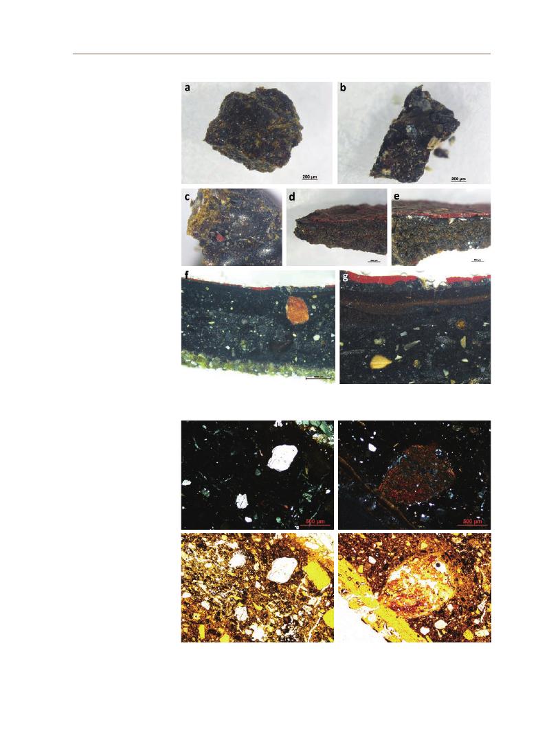
Figure 10 and Figure 11).
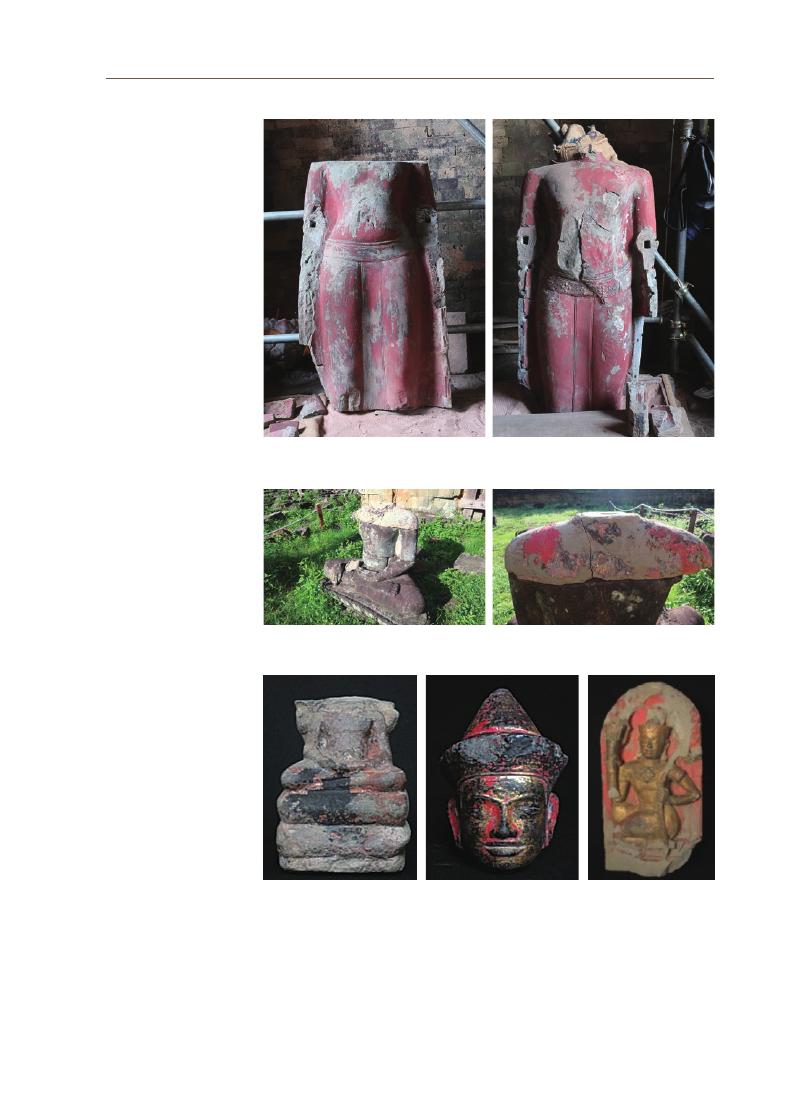
Major parts of the body of the stone statue in the Sanctuary of the Pre
Rup Temple were severely damaged. Though the exact time is unknown, the
lost parts have been restored using a massive amount of lacquer mortar. The
lacquer mortar was dark brown and very hard, lime mortar. Although it was not
observed on the fractured surface of the mortar, the pore surface within the
mortar exhibited a resinous luster. Additionally, traces of lacquer were found to
attach the white ornaments in the decorative belt of the Kor statue.
2 Sungyoon Jang, Lacquer
as Adhesive : Its Historical
Value and Modern
Utilization, Mumhwajae,
49(4), 2016.
3 Jonghun Lee, Haeri Jo,
Lacquer painting for basic
art theory, Hexagonbook,
2018.
Ⅳ
. Analytical
results for
lacquer
mortar

18
2. Stereoscopic analysis
The microstructural characteristics of the collected lacquer mortar samples
were analyzed. The color of the lacquer was translucent, the thick part of the
specimen was close to blackish brown while the thin part was close to golden or
light yellowish brown (Figures 12a and 12b). The resin luster was also distinct (Figure
12d).
The cross-section of the lacquer mortar attached to the pigment layer
looked blackish brown. The fractured surface was irregular; consequently, the
luster did not appear obvious and the texture looked loose (Figure 12e).
When the cross-section was enlarged, it was observed that there was a thin
layer with a darker color and more pronounced luster than the mortar between
the reddish-brown pigment layer and the lacquer mortar layer (Figure 12f). This
thin layer was considered as a lacquer finish or a lacquer base layer for the
succeeding layer of pigment. The pigment was applied with a uniform thickness
(
Figure 12f).
The cross-section of the specimen was polished and observed under a
stereomicroscope. A reddish-brown pigment layer was clearly observed.
Additionally, it was confirmed that various materials were added to the lacquer
sap. The round particles under the microscope were presumed to be mineral
particulates such as sand and clay, and other irregular angular substances were
Figure 10. Occurence of lacquer mortar in the Sanctuary of Pre Rup Temple
Jiy
oung Kim
19
Figure 11. Lacquer mortar samples collected from the Pre Rup
B‐1
B‐2
B‐3
B‐4
B‐5
G‐1
G‐2
K‐1
K‐2
K‐4
K‐5

20
presumed to be some sort of additives (Figure 12g).
When the polished cross-section was enlarged, it was observed that
several layers had formed between the pigment layer and the mortar layer.
The layer just below the red pigment layer did not contain a large amount of
particulate matter, and the succeeding layer exhibited a layered structure with
diverse thicknesses and colors. Moreover, it was observed that the pores were
distributed throughout the layer of the lacquer mortar. The sizes and shapes of
the pores were not constant (Figure 12h).
3. Polarizing microscopic observation
The thin-section observation of the sample under a polarizing microscope
showed a large number of mineral particles such as quartz and feldspar. The
varied size of the mineral particles corresponded to that of sand, silt, and clay
according to the standard soil classification criteria. A brown aggregate with a
diameter of about 1 mm was found. It was presumed to be an aggregate of clay.
It is likely that silty sand and clay were added to it. Considering that the quartz
and feldspar particles are highly rounded, it was presumed that aqueous clastic
sediments were formed by natural weathering processes rather than being
artificially crushed (Figure 13).
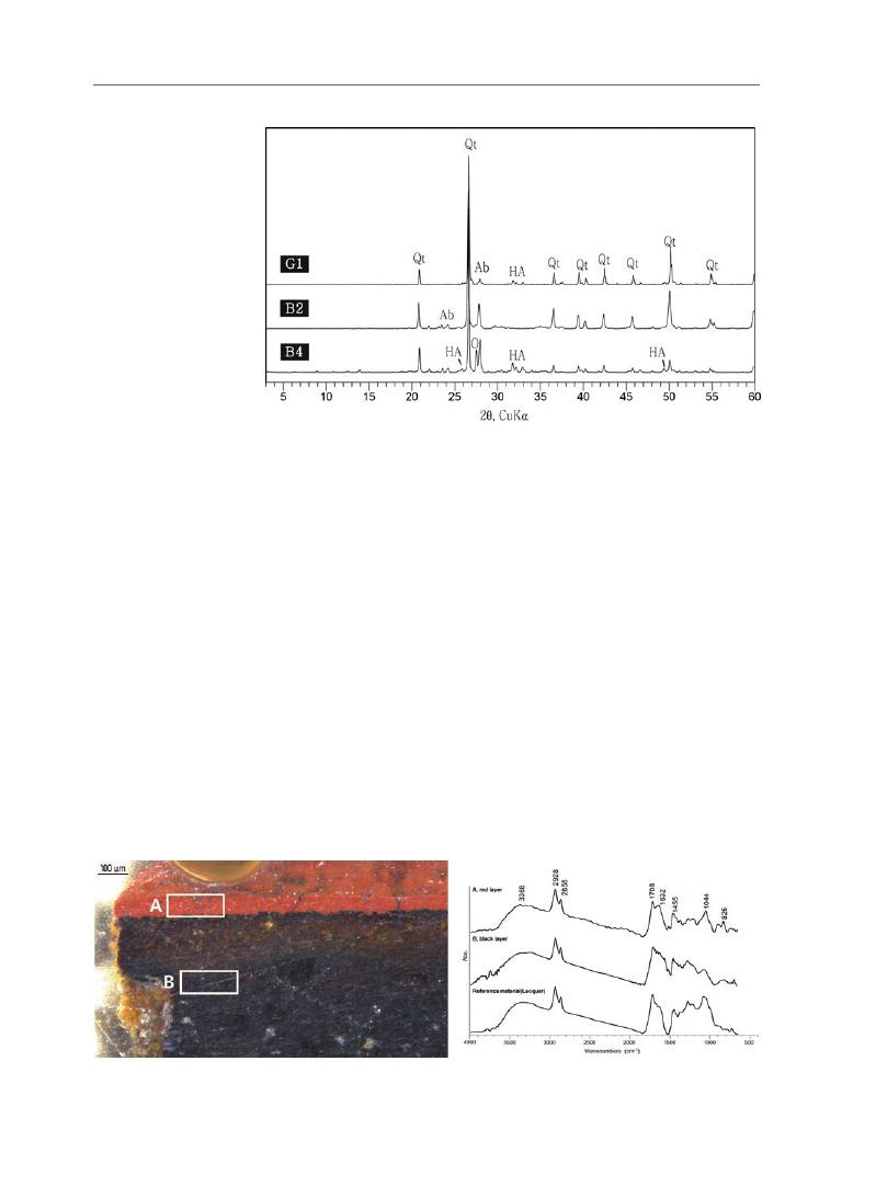
4. X-ray diffraction analysis
We conducted an X-ray diffraction (XRD) analysis for three lacquer mortar
samples. Quartz (Qt) and feldspar (Ab, O) were detected the most in the analysis
which meant that a large amount of soil was added to make the mortar. This
was also confirmed by the previous polarized microscopic analysis. Additionally,
hydroxyapatite (HA) was detected. It is an animal bone or tooth component
comprising calcium and phosphorus. It suggested that animal bones or similar
substances were added to manufacture the lacquer mortar (Figure 14).
5. FT-IR analysis
Among the samples collected from Pre Rup, those in which lacquer and
pigment were well preserved were prepared as specimens for microscopic
observation. After optical microscopy and SEM observations, the coated part
was polished again and used for FT-IR analysis. An infrared spectrometer (FT-
IR, Hyperion 2000, Vertex 70, Bruker, Germany)
with a microscope and diamond ATR
accessory was used. The following analytical conditions were set: a range of
4000 cm-1 to 650 cm-1 in the measurement area, the number of scans was set at
Jiy
oung Kim
21
Figure 12. Stereoscopic observation of the lacquer mortar samples
Figure 13. Polarizing microscopic images of lacquer mortar
22
64 times, and a resolution of 4cm-1.
An analysis of the red layer (A) and the black layer (B) of the B4 sample
(
Figure. 15)
showed the presence of phenolic hydroxyl groups (-OH) near 3300
cm-1 in a wide range. Methylene groups (-CH3, =CH2), which can be identified
characteristically in lacquer, were analyzed at 2928 cm-1 and 2858 cm-1 (Figure.
16).
Previous studies of thitsiol analysis showed that the main characteristic
absorption peaks were reported at 3500 cm-1 for the hydroxyl group, 2930 cm-1
for the methylene group, 1100 cm-1 for the phenolic hydroxyl group, and 1080
cm-1 for ether.4
After comparing it with the infrared absorption spectrum of the reference
material (lacquer), both the A and B analysis positions of the Pre Rup samples
were confirmed to be lacquer. Significant organic materials other than lacquer
could not be identified.
Figure 14. XRD patterns of the lacquer mortar
Figure 15. Analysis position by layer of lacquer mortar
Figure 16. Infrared absorption spectrum of lacquer
mortar (B4) sample
4 Rong Lu and Tetsuo
Miuakoshi, 2015, Lacquer
Chemistry and Applications,
Elsevier.

Jiy
oung Kim
23
Table 2. Sample status
Name
Collection location
Stereomicrograph (magnification, ×20~60)
G1
K1
K2
K4
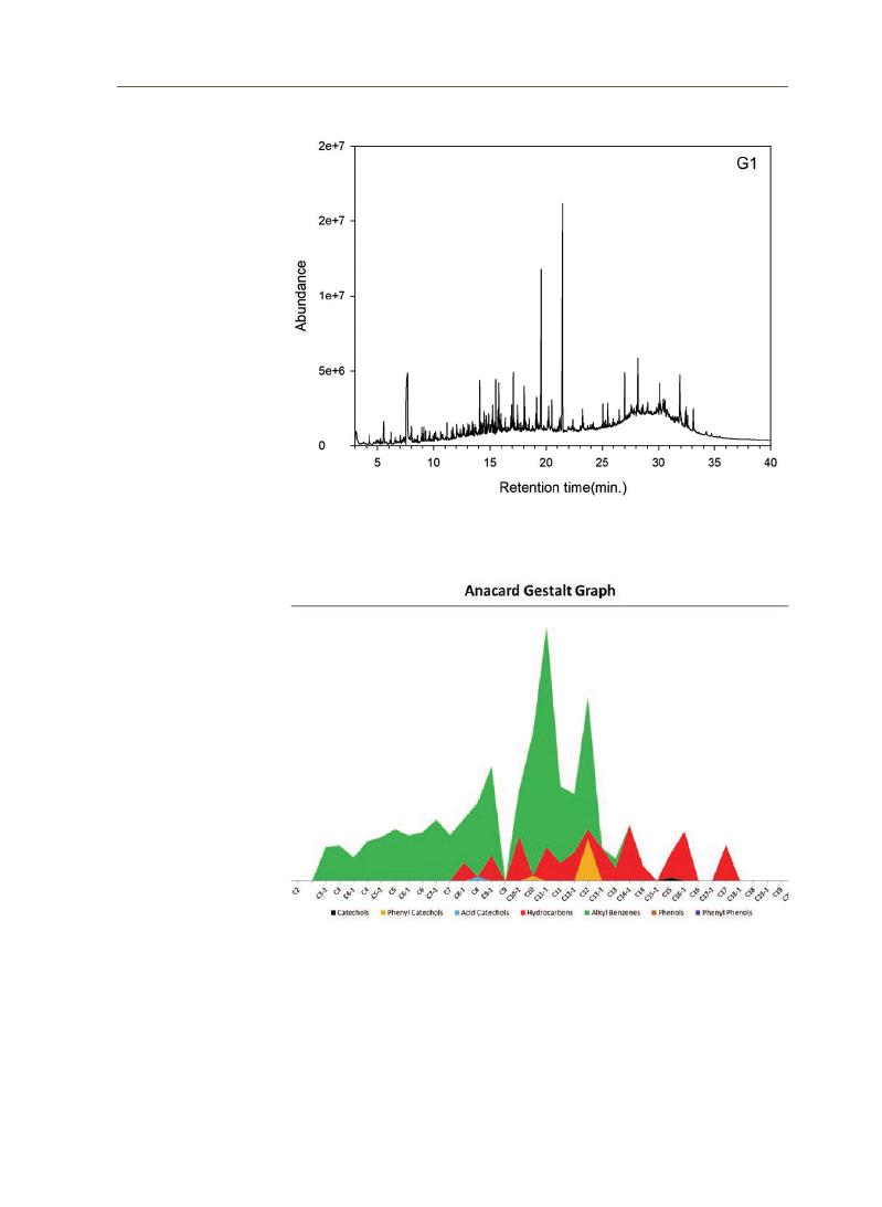
6. Py-GC/MS analysis
1) Samples and methods
Among the Pre Rup samples, the specimens were selected according to the
purpose of the lacquer. G1 is a lacquer sample with a clear resin luster taken
from the Gor, and K1 is the adhesive used to decorate the waist of the Kor. K2
is the pigment layer on the left arm of the stone statue of Kor, and K4 is the thin
black and gray film sample (Table 2). Py-GC/MS analysis was performed on G1,
K1, K2, and K4, and the analysis conditions are listed in Table 3.
24
2) Analysis result
(
1)
G1
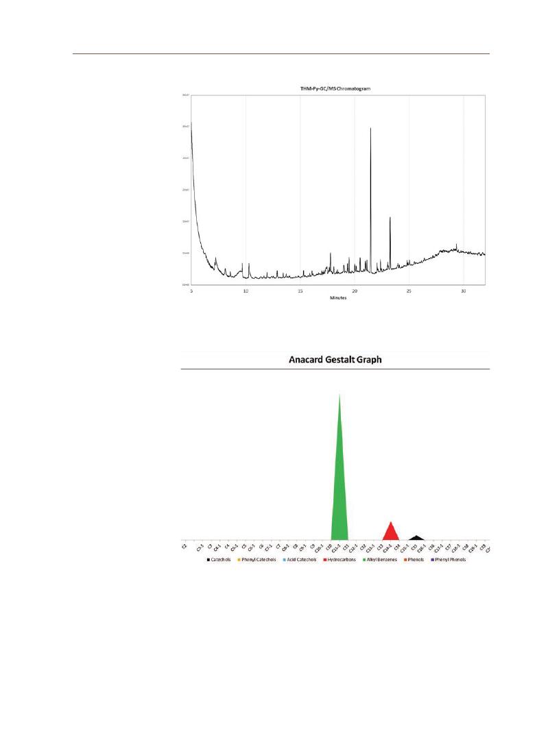
Alkyl benzene and phenyl catechol compounds were detected in thitsiol,
which is the main component of lacquer sap found in lacquer trees in Cambodia.
Ursonic acid methyl ester, nor-alpha-amyrone, and hexakisnor-dammaran-
3,20dione identified in dammar resin were detected as additives. However,
dammar resin has a characteristic that is difficult to identify when it has
deteriorated (requires confirmation with m/z 143). Olean-12en-28-oic acid, 3-oxo-
,
methyl ester was analyzed, and it may be a mastic resin. However, other
characteristic peaks were not identified. Other additives such as oil and protein
were not analyzed. Several fatty acids were identified, but glycerol was not
analyzed; therefore, it is presumed that oil was not used (Figures 17 and 18).
(
2)
K1
A graph of the typical titsi was identified. It was assumed that gum benzoin
was used as an additive (2-propenoic acid, 3-phenyl-, methyl ester/benzoic acid,
4-methoxy-, methyl ester/benzoic acid, methyl ester/methyl p-methoxycinnamate, cis).
A compound (diketodipyrrole) analyzed in glue was identified. Other pyrrole
compounds were not analyzed, and glycine, alanine, and pyridine were detected
(
Figure 19, 20).
Table 3. Instrument and analysis conditions
Pyrolyzer
(
PY-3030D, Frontier Lab, JPN)
Furnace
500℃, 1min
Gas Chromatography
(
7890A, Ahilent, USA)
Inlet
250℃, 20:1
Oven
50℃ (3min.) to 300℃ (5min); 10℃/min
Column
DB-1HT
(
30m×0.25mm id×0.10㎛)
Gas
He 0.5ml/min.
Mass spectrometry
(
5975C, Agilent, USA)
Mass range
m/z 33-600
Transfer temp.
280℃
Ion source temp.
230℃
Quadrupole temp.
150℃
Jiy
oung Kim
25
Figure 17. Pyrogram of G1 sample
Figure 18. Gestalt graph for G1 sample

26
Figure 19. Pyrogram of K1 sample
Figure 20. Gestalt graph for K1 sample
Jiy
oung Kim
27
(
3)
K2
An analysis of the lacquer finish layer under the red layer of the sample
confirmed compounds derived from thitsiol. Additionally, traces of using oil as an
additive (monocarboxylic fatty acids) were found but were not analyzed with certainty
(
Figures 21 and 22).
Figure 21. Pyrogram of K2 sample
Figure 22. Gestalt graph for K2 sample

28
Figure 23. Pyrogram of K4 sample
Figure 24. Gestalt graph for K4 sample
(
4)
K4
Lacquer was identified as typical thitsi, and no other additives such as resin
or oil were detected (Figure 23 and 24).
Jiy
oung Kim
29
Figure 25. SEM images of the lacquer mortar
7. Scanning electron microscopic analysis
Scanning electron microscopy (SEM) was performed. A homogeneous
distribution of small pores was observed at low magnification (Figure 25). The size
of the pores was approximately 10 ㎛. The dense particulates that appeared to
be mineral additives and the smooth texture of solidified lacquer were mixed.
It showed a mixture of sand particles with high roundness and angular to
subangular particulates of smaller sizes. These small angular to subangular
particulates were presumed to be bone powder as they appeared loosely
structured owing to several pores and microcracks. This distinguished them
from sand particles. A tubular and scale-like substance was presumed to be
animal hair.
EDS (Energy dispersive spectroscopy) analysis was performed on the polished
specimens. The dense, smooth, and relatively large particulates were
identified as quartz sand based on the remarkably high Si (silicone) content.
Particulates smaller than quartz were presumed to be clay or feldspar sand
as Al (aluminum) is detected in addition to Si (silicone). An area was found where

30
Ca (calcium) concentration was predominantly high in angular particles. These
particulates were of the bone powder with a high P (phosphorus) content. The thin
pigment layer was identified as a red pigment composed of iron oxide with a
predominantly high Fe (iron) content (Figure 26).
Figure 26. SEM-EDS mapping result

Jiy
oung Kim
31
Ⅴ. Discussion
and
conclusion
A basic scientific investigation was conducted on lacquer mortar used for the
reparation and restoration of stone statues found in Cambodia. Lacquer mortar
is prepared by mixing various additives in lacquer sap. It was used earlier to
bind broken parts of the stone statues and was often used to shape or fill in the
missing parts. Several such cases have been found in the Gallery of Thousand
Buddhas, Angkor Wat, and the stone statues in the Sanctuary of the Pre Rup
Temple.
Various scientific analytical methods were applied to the lacquer mortar
samples collected from the stone statues of the Pre Rup sanctuary. As
confirmed by microscopic observation, XRD analysis, and SEM-EDS analysis,
the lacquer mortar samples contained a large number of additives. Commonly
added materials were sand and bone. Quartz and feldspar sand, and bone
powder with calcium and phosphorus were identified. FT-IR and Py-GC/
MS analyses determined the lacquer as containing thitsiol, which is the main
component of lacquer tree sap grown in Myanmar, Cambodia, and Thailand. In
addition to thitsiol, resin-based substances collected from trees and barks, such
as dammar and mastic, were also identified. Thitsiol and gum benzoin was also
detected in the lacquer adhesive used in the decoration of the Pre Rup statue.
Only lacquer thitsiol was identified in some lacquer specimens without any other
substances.
Cambodian lacquer mortar is very similar in material to Golhoe from Korea,
China, and Japan. According to the research data on Golhoe from Korea, the
additives were soil, charcoal, and bone powder , although the component and
ratio altered slightly with time. It is believed that wood powder,5 wheat flour, coal
powder, and horse incense were also used,6 although obvious analytical data or
literature data to prove it were insufficient. The inorganic materials added to the
lacquer in Cambodia, Korea, China, and Japan are presumed to be almost the
same. Organic additives such as dammar, mastic, and gum benzoin were found
in Cambodian lacquer mortar. It was reported in previous research that rice
husk ash, fatty acids, and tannins were also identified in Cambodian lacquer.7
However, this was not clearly confirmed in this study. Several materials added
to lacquer to make it functional vary greatly depending on region and era.
Accordingly, the components to be detected also vary depending on the type of
object analyzed. Additionally, it is possible that the deterioration of old lacquer
also affected the analysis results.
Only a few studies on Cambodian lacquer exist as scientific analyses on
it are rare in comparison to those on lacquers found in Myanmar or Vietnam.
5 Seulyoung Lim, The Modern
Transformation of Bone
Ashes and Its Cause, Korean
journal of art history, 305,
2020.
6 Eunjeong Jang, Junghae
Part, Soochul Kim, A Study
on Conservation Materials
of the Lacquer Wares: the
Tohoe and Goksu, Journal of
conservation science, 31(2),
2015.
7 Haana Szczepanowska and
Rebecca Ploeger, 2019,
The chemical analysis of
Southeast Asian lacquers
collected from Forests and
workshops in Vietnam,
Cambodia, and Myanmar,
Journal of Cultural Heritage.

32
Therefore, based on the results of this basic research, it is necessary to
conduct additional analysis and in-depth studies in the future to determine the
characteristics of lacquer from different Cambodian regions and periods. The
results obtained from this study will be used as basic data for the same and to
revive the traditional lacquer techniques of Cambodia.

Jiy
oung Kim
33
References
Acknowledgements
Junghae Park, Yonghee YI, A study on investigation of gold painting technique
in the lacquerwares of Goryeo, Conservation science in museum, 14,
2013.
Jonghun Lee, Haeri Jo, Lacquer painting for basic art theory, Hexagonbook,
2018.
Kwonwoong Lim, Jonghun Lee, A study on Sobyuks : technique of Goguryeo
Tomb Murals, The KoguryoBalhae Yonku, 30, 2008.
Seulyoung Lim, The Modern Transformation of Bone Ashes and Its Cause,
Korean journal of art history, 305, 2020.
Sungyoon Jang, Lacquer as Adhesive : Its Historical Value and Modern
Utilization, Mumhwajae, 49(4), 2016.
Eunjeong Jang, Junghae Part, Soochul Kim, A Study on Conservation Materials
of the Lacquer Wares : the Tohoe and Goksu, Journal of conservation
science, 31(2), 2015.
Haana Szczepanowska and Rebecca Ploeger, 2019, The chemical analysis of
Southeast Asian lacquers collected from Forests and workshops in
Vietnam, Cambodia, and Myanmar, Journal of Cultural Heritage.
Masako Miyazato, Rong Lu, Takayuki Honda, Tetsuo Miyakoshi, “Lao lacquer
culture and history—Analysis of Lao lacquer wares”, Journal of Analytical
and Applied Pyrolysis, 103, 2013.
Rong Lu and Tetsuo Miuakoshi, 2015, Lacquer Chemistry and Applications,
Elsevier.
Yingchun Fu, Zifan Chen, Songluan Zhou, Shuya Wei, “Comparative study of
the materials and lacquering techniques of the lacquer objects from
Warring States Period China”, Journal of Archaeological Science, 114,
2020.
This research was funded by the 2021 UNESCO Chair Research Grant Project of
Korea National University of Cultural Heritage.

Jong-wook Lee Professor, KNUCH
Bo-ram Kim Researcher, KNUCH
Seon-mi Kim Researcher, KNUCH
Development of Photogrammetry
Education Program for 3D Digital Scan of
Cultural Heritage
Various interdisciplinary studies are needed in the field of heritage, and the
fourth Industrial Revolution has established projects utilizing digital technology
related to the excavation, conservation, and utilization of heritage. However,
owing to the characteristics of digital technology, it is not easy for laypeople
to access cultural heritage through it, which is an aspect field of heritage that
requires to be worked upon in the future.
This study thus developed a photogrammetry education program—a digital
technology for workers engaged in the field of heritage. The concepts and
definition of digital heritage were first examined. Digital heritage is a digital
approach to heritage that involves the transformation of physical heritage into
a digital form. Additionally, the concept of born-digital heritage is also defined
as digital heritage in accordance with the Charter on the Preservation of Digital
Heritage.
The importance of digital education in the field of heritage is recognized by
several countries such as the United States, the United Kingdom, and South
Korea. The necessity for the education and application of digital technology is
emerging with the complex changes in the functioning of museums. Hence,
we intend to encourage the use of digital technology in the field of heritage by
developing educational programs for people working in this field in the Asia-
Pacific region.
In conclusion, photogrammetry, aiding in acquiring and generating 3D data,
was selected, and its basic principles, preparations, and practical methods
were studied. Consequently, the goal is to acquire photogrammetry skills easily
through an educational handbook, irrespective of the location of the workers, by
creating an educational program that can educate workers engaged in the field
of heritage in the Asia-Pacific region.
Abstract
Survey Research Papers on Materials and Techniques in the UNESCO Chair Programme
02

35
Jong
-w
ook Lee
1. Cultural Heritage
The United Nations Educational, Scientific and Cultural Organization (UNESCO)
defines heritage as the living heritage inherited from our ancestors to be passed
on to future generations (UNESCO, n.d.). Currently, South Korea uses the term
cultural property (문화재; Munwahjae) as a legal term for cultural heritage. The
Cultural Heritage Protection Act, enacted to promote the cultural improvement
of the people and to contribute to the development of human culture, defines
cultural heritage as follows.
The term “cultural heritage” in this Act means artificially or naturally formed
national, racial, or world heritage of outstanding historic, artistic, academic, or
scenic value.
(Cultural Heritage Protection Act, Article 2 (definition), 2020)
As defined above, cultural heritage lives with us in the present, and it is
important to pass on its value intact to the next generation (Venice Charter 1964).
This means that cultural heritage must be properly excavated, conserved,
managed, and utilized in the communities in which it exists. John Ruskin (1849,
179)
argued that cultural heritage should be utilized by all generations and that
the present generation has no right to alter or destroy it.
However, it is important to utilize cultural heritage sustainably, because the
conservation of cultural heritage is to respect not only the present generations
but also the future generations. Various methods have been suggested to utilize
cultural heritage sustainably and to maintain its integrity. This study recognizes
the digital formats of the resources and information related to cultural heritage
as the concept of digital heritage. We will suggest ways to maintain the
authenticity and integrity of cultural heritage.
2. Digital Heritage
Since the 1990s, with the advent of the Information Age, the digitization of
information on heritage has been undertaken. It has brought about changes
in the museum and cultural heritage management systems (Ahn and Kim 2016,
5).
In accordance with these changes, UNESCO and several other international
organizations have begun to pay attention to the concept of digital heritage. In
2001, the UNESCO Council discussed the preservation of digital heritage, paying
special attention to the issues of digital preservation faced by the European
Commission on Preservation and Access (ECPA) (Ahn and Kim 2016, 5).
Ⅰ. Digital
Heritage

36
Accordingly, UNESCO drafted the Charter on the Preservation of Digital
Heritage in 2003, which outlined the definition of digital heritage, approach
towards it, threats from loss of cultural heritage, the need for action, and digital
continuity. The Charter defines digital heritage and its scope as follows.
The digital heritage consists of unique resources of human knowledge and
expression. It embraces cultural, educational, scientific and administrative
resources, as well as technical, legal, medical and other kinds of information
created digitally, or converted into digital form from existing analogue resources.
(UNESCO, 2003)
As mentioned above, digital heritage not only includes the cultural heritage
expressed and reproduced in digital form but also the concept of born-digital
originally created by digital technology. In particular, Mckenzie and Poole
extended the concept of digital heritage to a ‘digital approach to heritage’ (Mckenzie
and Poole 2010 cited in Ahn and Kim 2016, 6–7).
Several relevant international charters
can confirm the importance and scope of digital heritage.
3. Charters on Digital Heritage
International charters on digital heritage include the Universal Declaration
on Cultural Diversity (2001), Charter on the Preservation of Digital Heritage
(
2003),
UNESCO Recommendation concerning the Promotion and Use of
Multilingualism and Universal Access to Cyberspace (2003), The London Charter
for the Use of 3-Dimensional Visualisation in the Research and Communication
of Cultural Heritage (2006), and Recommendation Concerning the Preservation
of, and Access to, Documentary Heritage Including in Digital form (2015). These
charters deal with the relationship between culture and the digital world and
display the following characteristics.
1. Professionals in the Field of Heritage
Various types of workers are employed in the heritage field based on their
qualifications. There are museum and art gallery curators, culture and arts
educators, cultural tourism docents, cultural heritage repair technicians (Kim
2012),
amog others. For this study, a museum curator, who practices cultural
heritage, was selected to take an educational program on digital heritage. The
International Council of Museums (ICOM) Korean Committee defines museum
workers as follows.
Ⅱ. Education
on Digital
Heritage

37
Jong
-w
ook Lee
Table 1. Charters on Digital Heritage
Year
Charters
Contents
2001
Universal Declaration on
Cultural Diversity
Article 6 declares cultural diversity for all and codifies measures to ensure
the free flow of ideas in text and images, while at the same time allowing
all cultures to express and promote themselves.
2003
Charter on the Preservation
of Digital Heritage
Establishment of a concept for the conservation and management of
UNESCO digital heritage, guaranteeing access to digital heritage including
born-digital heritage.
2003
UNESCO Recommendation
concerning the Promotion
and Use of Multilingualism
and Universal Access to
Cyberspace
Recognizing that the restriction of the use of multiple languages in the
global information network hinders the securing of universal access to
the digital environment. The purpose is to promote a solution through
international cooperation.
2006
The London Charter for
the Use of 3-Dimensional
Visualisation in
the Research and
Communication of Cultural
Heritage
It covers a wide range of applications such as the arts, humanities, and
cultural heritage that use 3D visualization for research and dissemination
and includes measures to clarify the 3D visualization of digital models.
2015
Recommendation
Concerning the
Preservation of, and Access
to, Documentary Heritage
Including in digital form
In relation to the Memory of the World, UNESCO members should lead
exchanges and cooperation related to preservation and accessibility
enhancement of documentary heritage, emphasizing the establishment
of a continuous network with the private sector and internal and
external expert groups and related institutions, as well as international
organizations.
“
Museum workers” includes all people engaged in the museums recognized by
ICOM and institutions that conduct educational and research activities useful
for museum activities, and they have received training in a field appropriate to
museum activity and operation or have had practical experience equivalent to that.
(ICOM Korea 2013).
In the past, museums and art galleries focused on the role of collection,
research, and exhibition of relics; however, due to recent development and
the diversity of relics, their functions have been expanded to serve as complex
cultural facilities (Choe et al 2019). Choe (2019, 97) emphasized the strengthening
of the educational functions in museums and argued that the roles of curators
should be diversified. It can thus be confirmed that digital education for museum
workers is considered as one of the requirements necessary to enhance the
sustainable development of museums and art galleries.
2. The Necessity of Digital Education
Digital education is crucial for future generations. Attempts to combine
the ICT technology of the fourth Industrial Revolution with existing educational
methods are emphasized. They are based on competency-oriented education
and creative convergence education.

38
Competency-oriented education refers to the cultivation of competencies
necessary for future generations. It cultivates the learners’ ability to utilize
and apply knowledge rather than simply acquiring it (Lim 2019, 260). Major
international organizations such as the OECD and EU have suggested future
core competencies (Jung & Kim 2019, 337). Among them, the Partnership for 21st
Century Skills project recommends the following core competencies.
As shown in Figure 1, the Partnership for 21st Century Skills mentions
competencies such as life and career skills, learning and innovation skills, and
information, media, and technology skills (P21 2009). It emphasizes computational
thinking along with creativity, critical thinking, communication, and collaboration
under information, media, and technology skills that were previously suggested
(
Lim 2019, 259).
In the case of the UK, computational thinking was applied to the regular
curriculum (CAS & Naace 2014, 4). South Korea also emphasizes the significance of
computational thinking in the Software Education Operation Guidelines of 2015
(
Ministry of Education 2015).
Creative convergence education refers to the ability to creatively use and
approach the knowledge and technology of the fourth Industrial Revolution.
Jung and Kim (2019) also suggested an art education plan that strengthens
competencies by converging technological capabilities in artistic creation
and cultural enjoyment. Convergence education started with STEAM (Science,
Technology, Engineering, Arts, and Mathematics)
in the United States, which teaches
art with STEM (Science, Technology, Engineering, and Mathematics). It helps reinforce
strengths that provide a wide range of convergence education such as creativity
and imagination (Kang 2015, 7).
In the educational field, emphasis is laid on creative convergence education
Figure 1. 21st Century student competency framework (partially restructured by the
author) (Source: Partnership for 21st Century Skills 2009, 1)
Life and
Career Skills
Learning and
Innovation Skills
Core Subjects and
21st Century Themes
Information,
Media, and
Technology
Skillds

39
Jong
-w
ook Lee
that encourages creative use by applying competency-oriented computer
thinking and the fourth Industrial Revolution technology to the field of culture
and art. Therefore, this study suggests a digital heritage education program
suitable for the present era by adopting an educational method that applies
digital technology to the field of heritage education. The subject for digital
heritage education is the staff working in institutions related to cultural heritage.
We aim to provide a digital heritage education program that can be applied in the
Asia-Pacific region. Consequently, instances of active studies being conducted
abroad, where digital technology is applied to heritage education, were analyzed.
3. Heritage Education Programs Using Digital Technology
1) CIPA Heritage Documentation Summer School
CIPA Heritage Documentation organized an annual summer school to
educate archaeologists, architects, historians, and surveyors on the correct way
to document, survey, and model cultural heritage. In this program, participants
gained firsthand experience in 3D surveying, photogrammetry, and laser
scanning conducted in the laboratory and on the field.
Table 2. The Schedule of CIPA Heritage Documentation Summer School
No.
Date
City
1
July 5–12, 2014
Paestum, Italy
2
July 12–19, 2015
Paestum, Italy
3
August 30 – September 3, 2016
Valencia, Spain
4
July 12–18, 2017
Paphos, Cyprus
5
July 15–21, 2018
Zadar, Croatia
6
September 2019
Manila, Philippines
7
July 14–20, 2019
Gyeongju, Republic of Korea
Figure 2. CIPA SUMMER SCHOOL 2019 in Gyeongju (Source: CIPA Heritage Documentation)
40
Figure 3. CIPA Gyeongju training program schedule (Source: CIPA Lecture Notes)
Figure 4. CIPA Gyeonju lecture content (Source: CIPA Lecture Notes)
Lists of Lectures
01
Andreas GEORGOPOULOS
Photogrammetry
02
Fabio REMONDINO
Laser scanning
03
Efstratios STYLIANIDIS
Topography
04
Abhijit DHANDA
Photography
05
Isabella TOSCHI
Demo CloudCompare
06
Elisa FARELLA
Demo Metashape

41
Jong
-w
ook Lee
Table 3. Cultural Heritage Imaging Programs
Programs
Content
1
4-Day photogrammetry
training
See how to acquire photogrammetric image sets and create scientific 3D
documentation.
Experience how to build 3D content using equipment, image capture setup, and
software.
2
4-Day RTI training
Learn how to use Highlight RTI to create digital representations of various objects.
Develop the ability to implement digital imaging workflows, including capturing,
processing, and viewing RTI digital representations.
3
CHI training with an
expert
4-day training classes on RTI and photogrammetry with direct visits from CHI
experts.
4
Half-day workshop
Learning digital imaging skills in the field of conservation and education. Held for
archaeologists, photographers, or staff of museums or libraries.
2) Cultural Heritage Imaging
Cultural Heritage Imaging (CHI) is a non-profit organization that develops
practical digital imaging and conservation solutions. It leads the adoption of
these technologies by cultural heritage stakeholders to preserve cultural
heritage before it is lost. Its goal is to universalize technology so that people
worldwide can document their cultural heritage and preserve and protect it
for future generations. CHI technologies comprise new and easily learnable
imaging techniques (photogrammetry and reflectance transformation imaging (RTI)) along
with various tools, skills, and training.
3) CyArk
CyArk is a non-profit organization established in 2003 with the goal of
archiving, storing, and sharing digital heritage. Currently, over 200 sites have
been documented, and 3D documentation training programs are provided
for students through workshops. In June 2021, CyArk and Capturing Reality
collaborated to provide a joint educational workshop on the topic of 3D
Figure 5. Educational environment at Cultural Heritage Imaging (Source: CHI)
42
documentation for students at the Academy of Arts in Banská Bystrica and the
Technical University of Košice. The two-week course provided students with
training to record historical sites using photogrammetry techniques and to
create virtual reality scenes and 3D models
1. Digital Records in the Field of Heritage
The International Council on Monuments and Sites (ICOMOS) adopted the
‘
Principles for the Recording of Monuments, Groups of Building and Sites
(
1996)’
in 1996, stating that records are an important part of the preservation
process (ICOMOS 1996, 49). Recording has become an indispensable process in the
conservation of cultural heritage, and digital technology has helped to improve
the speed, accuracy, and data quality of cultural heritage documentation. Digital
technology enables the recording and analysis of high-quality cultural heritage
data at a high speed, and the results of the analysis facilitate the establishment
and implementation of cultural heritage conservation plans. These results
were shared by experts and related parties and used in the conservation,
management, and utilization of cultural heritage.
2. Digital Recording Technology
Several technologies can be used to record cultural heritage, and the
application of these technologies depends on the type and properties of the
cultural heritage being documented. The format of digital recording includes 2D
images, 3D shapes, sounds, and motions. Figure 7 shows how 3D data of cultural
heritage is acquired through contact and non-contact methods depending on
Figure 6. Preserving Slovakian Heritage Workshop at CyArk (Source: Cyark nd)
Ⅲ. Digital
Recording
Technology

43
Jong
-w
ook Lee
Figure 7. Classification of 3D scanners by scanning method (edited by the author) (Source: Cultural Heritage Administration
2018, 12)
whether the scanner is in contact with the surface of a relic or not. The non-
contact method is further bifurcated into an active method, which is a distance-
based method obtained by firing a laser or light, and a passive method, which is
an image-based method that calculates 3D data by recognizing an object using
an image sensor. The use of the non-contact method for data acquisition is
suitable for cultural heritage sites to maintain their integrity.
Figure 8. Investigation technology according to the characteristics and size of the object
(
Source: Historic England 2018, 2)

44
1) 3D scanning
3D scanners record the 3D coordinates of numerous points on the surface
of an object within a relatively short time period. In this process, a laser beam
is projected onto the surface of the object (Boehelr et al 2001, 1). The 3D scanner
operates through the time-of-flight method, the phase shift method, and the
triangulation method. The precision scanner uses the triangulation method
(
Cultural Heritage Administration 2018, 13).
2) Photogrammetry
Photogrammetry is a technology that extracts 3D form information by
acquiring images of stationary objects from various angles and positions. This
is an image-based modeling technique included in SfM (Structure from Motion)
technology that interprets the structure of an object from motion.
In this study, educational content on 3D data generation of cultural heritage
was developed, focusing on photogrammetry technology, so that workers in
the field of cultural heritage can acquire data in a short time at a relatively low
price and with easy access. The technical characteristics of 3D scanning and
photogrammetry are compared in Table 4.
Table 4. Comparison of technical characteristics of 3D scanning and photogrammetry
Categories
3D Laser Scanning
Photogrammetry
Technology base
Distance
Image
Price
Expensive
Cheap
Operability
Low
High
Date Acquisition Time
Long
Short
Modeling of Complex
Shape
Difficult
Easy
3D information
Direct Acquisition
Extraction
Distance Dependence
High
Low
Space Dependence
High
Low
Material Dependence
High
Low
Light Dependence
Varies by Machines
High
Date Size
Large
Depends on Resolution
Texture
Low resolution
Including
Open Software
Few
Several

45
Jong
-w
ook Lee
IV.
Photogrammetry
1. Basic Principles
1) What is photogrammetry?
Photogrammetry is a method of measuring an object by taking its image.
Qualitative data, such as the color of the object and the degree of wear, and
quantitative data, such as the height and size of the building, can be obtained
from the survey by measuring the acquired photos.
Photographers must follow certain rules and procedures to obtain correct
data through photogrammetry. Photogrammetry proceeds in the following
order: 1) image capture, 2) image matching, and 3) point cloud generation. The
preparations differ depending on the size, characteristics, and condition of the
object. This photogrammetry course focused on the method of photographing
artifacts of 20cm×20cm or less so that relatively small artifacts can be
photographed.
2) Needs
Photogrammetry supplies for small artifacts include a DSLR camera, tripod,
lighting, white background paper, release, color reference card, turntable, and
software (3DF Zephyr, Reality Capture, etc.).
2. Photography
Photography refers to recording the shape of an object by adjusting the light
sensitivity, aperture, and exposure time. To use photogrammetry technology
correctly, an understanding of photography and the art of handling cameras is
essential. It is necessary to check the basic parameters of sensor sensitivity (ISO),
aperture, and shutter speed among the main operating elements of the camera
to properly record the shape of the artifact.
Figure 9. The three factors of photography (Source: Hamberger Fotospots, n.d.)
46
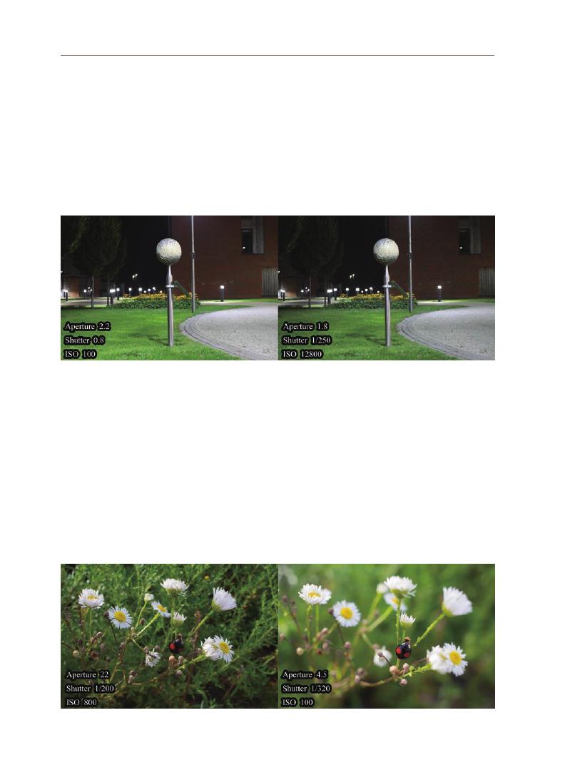
1) Sensor sensitivity (ISO)
ISO is a measure of the sensitivity of a camera’s image sensor. Until
the 1980s, each country had a non-uniform standard for sensitivity, but the
International Organization for Standardization set a film sensitivity standard that
can be used worldwide. The sensitivity of the sensor is often called ISO sensitivity.
In general, the lower the sensitivity of the camera, the less light it receives, and
the higher the detail and saturation of the picture, the clearer is the picture.
2) Aperture
Aperture is defined as the degree to which the lens opens. The light hits the
sensor through the lens, and the amount of light is limited by the degree to which
the lens is opened. When the aperture is opened, the amount of light increases,
and the image becomes brighter. Consequently, the depth of focus becomes
shallow and the front and rear parts except for the focused part blur the image.
Conversely, if the aperture is closed owing to the high number of apertures, the
amount of light is reduced. Consequently, the depth of focus is deep and clear
images can be obtained.
Figure 10. Comparison of quality degradation according to ISO manipulation (ISO 100 versus ISO 12800) (Source: Kim 2019)
Figure 11. Comparison of changes in the focus of photos according to the manipulation of the aperture value (aperture 22
versus aperture 4.5) (Source: Kim 2019)

47
Jong
-w
ook Lee
Figure 12. Comparison of photos according to shutter speed manipulation (shutter speed 1/3200 sec. versus 1/15 sec.)
(
Source: Kim 2019)
3) Shutter Speed
The shutter speed or exposure time refers to the amount of time the image
sensor inside the camera is exposed to light. The faster the shutter speed, the
clearer the dynamic picture can be obtained, but the lesser the light entering
the sensor, the darker the picture can be obtained. Furthermore, the slower
the shutter speed, the harder it is to capture dynamic photos, but the longer the
sensor is exposed to the light, the brighter the photos can be obtained at times in
places with low light, such as at night or indoors.
3. Application to Small Objects
Photogrammetry requires the application of different surveying techniques
depending on the size, shape, and condition of the object. It is necessary to pay
attention to the focal length of the lens, the control of the light, and the location
of the artifacts while conducting it. In the case of small artifacts displayed in
museums and art galleries, it may be advantageous to use a macro lens that can
take pictures at a short distance from the subject. It is recommended to set up
the lighting and tents in a manner that can disperse the light evenly and control
it. Additionally, high-quality data can be obtained by improving the shooting
environment using turntables, scale bars, and color reference cards.
1) Macro lenses
A macro lens is a lens that is optically designed to focus closer to a subject.
Regardless of the focal length of the lens, it can be used if it has a macro
function; however, as it gets closer to the subject, it is easier to use a wide-angle
lens to capture the entire range of the artifact. However, sometimes a telephoto
lens is needed to photograph artifacts such as coins. A 40–60 mm lens is called
a standard lens, a lens with a shorter focal length than that of the standard lens
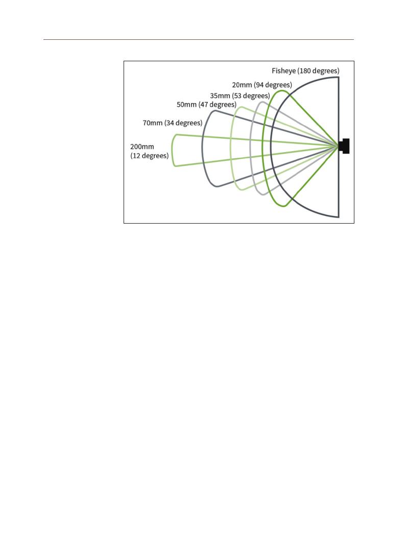
48
is called a wide-angle lens, and a lens longer than the standard lens is called a
telephoto lens.
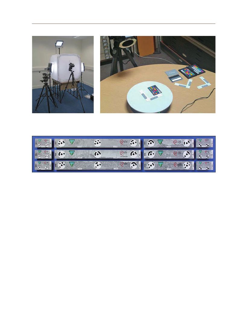
2) Lighting tent
In the case of small artifacts, shadows may occur depending on the location
of the lighting in the studio, which may prove to be problematic in acquiring data.
Accordingly, shadows on the relic should be minimized, and the material of the
relic that does not reflect light is ideal to obtain photos for photogrammetry.
Moreover, the light should be evenly dispersed. There is a technique to use the
tent to disperse the light. After installing the tent, if LED lights are installed
outside it, the light is evenly dispersed inside the tent. The tent is easy to set up
so that the light can be dispersed evenly.
3) Turntables
Turntables are used while photographing small artifacts. The turntable is
used to rotate the artifact while the camera is fixed at a particular spot. The
advantage is that 360-degree recording is possible with the camera, lighting,
and tent fixed, so the intensity of light can be uniformed. Additionally, it reduces
the acquisition time of image data by reducing the time required to set up the
camera and lighting.
Figure 13. Shooting range according to the focal length of the lens
(
Source: Historic England 2017, 29)
49
Jong
-w
ook Lee
4) Scale bars
The scale bar acts as a measure to check the distortion that occurs during
the shooting. When shooting an artifact, the actual size of the artifact can be
checked, which is necessary to create an accurate 3D model of the artifact.
5) Color reference card
The color checker helps photographers adjust the white balance by checking
the color of the image on the computer. White balance refers to adjusting the
color balance of the color to match it to the original one by neutralizing the color
of the photographed light.
Figure 14. Dispersion of light and shadow
removal using a tent (Source:
Historic England 2017, 107)
Figure 15. Tools used to photograph small artifacts (Turntable, scale bar,
and color checker) (Source: Historic England 2017, 76)
Figure 16. The scale bars produced by Cultural Heritage Imaging (Source: Cultural Heritage Imaging, n.d.)
50
4. Practice
In this photogrammetry handbook, Reality Capture and 3DF Zephyr were
the programs used for aligning the photos of a relic. Reality Capture especially
provides the advantages of good performance, fast processing speed, and easy
operation. This handbook dealt with a replica of Goryeo celadon, one of Korea’s
representative artifacts, applied with the inlay technique as a target artifact. The
procedure for generating a 3D model of the artifact utilizing photogrammetry is
as follows (see Appendix 1).
Table 5. Practice creating 3D models of small artifacts using photogrammetry
1. Selection of an artifact
2. Setting up the environment
Select the artifact you want to create
a 3D model of from the museum
or art gallery. Since the difficulty of
acquiring image data varies depending
on the size and shape of the artifact, a
simple artifact is recommended in the
beginning.
Set up the environment by installing
tents, lighting, turntables, color
checkers, and scale bars. Rather than
direct light, it is better to have an
environment where the lighting light
passes through the tent and the light is
dispersed evenly.
3. Taking an Artifact
4. Data Acquisition
Rotate the turntable and take pictures
of artifacts. It is recommended to rotate
the turntable at an angle of about 15
degrees. When shooting, consider the
focus and image shake.
Acquire image data using photography
skills suitable for the artifact. When
acquiring image data, the more the
overlapping parts of the image, the
better the image alignment. The height
of the camera is adjusted based on the
artifact, and several shots are taken.

51
Jong
-w
ook Lee
5. Data Alignment
6. Generating High-Density Point
Clouds
Use the application to match the artifact
data. The initial data arrangement
produces a low-density point cloud.
Based on the generated low-density
point cloud data, more points are
connected to create a high-density point
cloud.
7. Generating Mesh Data
8. Generating Textured Mesh
and Export Object File
Generate mesh data based on high-
density point clouds.
If the generated data is processed into a
textured mesh and exported as an object
file (OBJ), the 3D model can be used in
applications that support OBJ extension.
This study aimed to produce a photogrammetry education program for 3D
digital scanning of cultural heritage for professionals working in the field of
heritage. The concepts and definition of digital heritage were researched and
charters related to it were examined. Digital heritage has been defined in various
forms and can be summarized as computerized materials with lasting value that
should be preserved and transmitted to future generations (Lee 2019). After the
UNESCO Charter on the Preservation of Digital Heritage was published in 2003,
the concept of digital heritage was expanded and discussions on digital heritage
were actively conducted.
Chapter 2 examined the definitions of the types of professionals in the
V. Conclusion

52
heritage field and the museum workers discussed in ICOM to examine the
importance of digital heritage education. The museum has particularly
developed into a complex cultural facility due to the diversity of the artifacts on
display. With the advent of the information age, museum curators must acquire
knowledge about digital heritage. Additionally, as the ICT technology of the fourth
Industrial Revolution is being applied to educational methods, the necessity of
digital education for workers in the heritage field has been in demand. Currently,
more cultural heritage education programs using digital technology are being
actively conducted in European countries than in the Asia Pacific region.
Digital recording technology plays an important role in the conservation of
cultural heritage, and the ‘Principles for The Recording of Monuments, Groups
of Building and Sites (1996)’ codified the importance of documenting cultural
heritage. In this study, 3D scanning, and photogrammetry were compared, and
the photogrammetry technology, which provides the advantages of relatively low
price, easy access, and fast data acquisition, was selected as the target of the
education program.
Photogrammetry is based on photography, and the adjustments in ISO
(
Sensor sensitivity),
aperture, and shutter speed play significant roles. The
handbook selected relatively small relics, found in huge proportion in museums,
and accordingly, a macro lens, a tent for lighting control, a turntable, a scale
bar, and a color checker were selected. The practice module was developed
by confirming the need for the photogrammetry technology studied in this
paper, and the procedure of 3D model production was explained with actual
photographs. Celadon, one of the relics mainly found in the Asia-Pacific region,
was selected as the target relic. A celadon is apt to teach the concept of light
control and is advantageous because beginners can easily access them due
to their simpler appearance. Then, using Reality Capture, which is easier
to operate than other softwares, the practical methods and procedures for
photogrammetry were introduced.
Although this study did not provide an in-depth understanding of
photogrammetry, it served its purpose of providing a working knowledge of
its techniques to the laypeople working in the field of heritage. It allowed for
non-major professionals in the heritage field to apply digital technology to
the cultural heritage easily. It made it easy for them to acquire the theoretical
understanding and practical skills regarding digital heritage, digital recording
technology, and photogrammetry through the textbook without any other
learning programs. Consequently, starting with this textbook, it is expected that

53
Jong
-w
ook Lee
educational programs on the application of technology onto the heritage field for
people who work in this field will continuously be developed in the Asia-Pacific
region.
In the future, producing and managing content related to cultural heritage
will become a priority for the related institutions. Therefore, a curriculum should
be proposed for people working in the heritage field to learn the database
management method and the concept of metadata required for museum artifact
data management. Additionally, the digital heritage objects generated in this
manual can lead to the production of digital heritage content such as virtual
museums and H-BIM. In conclusion, we will suggest a curriculum based on
the concept of digital heritage and the manual of content production as a future
study.

54
Ahn, JH and Kim, CS (2016) Digital Heritage: 3D recording and utilisation of
heritage. Seoul: Sigmapress.
CHA (2018) Guidelines for constructing cultural heritage 3D scan data.
Daejeon: Cultural Heritage Administration.
CHI (nd) Cultural Heritage Imaging, the USA. Available at:
http://culturalheritageimaging.org/ [accessed 15 June 2021]
CIPA (nd) The International Committee for Documentation of Cultural Heritage
(CIPA), Italy. Available at: https://www.cipaheritagedocumentation.org/
join/ [accessed 15 June 2021]
Computing At School and Naace (2014) Computing in the national curriculum -
A guide for secondary teachers. Bedford: Newnorth.
Choe, JH, Do, JP, Jang, HS, Jeong, JH, Jeong, SC, Lee, SY, and Kim HJ (eds)
Understanding Cultural Properties Management, 3rd edn. Buyeo: Korean
National University of Cultural Heritage.
Cultural Heritage Protection Act 2020 (South Korea). Seoul: MGL.
CyArk (nd) Our Mission, Oakland. Available at: https://www.cyark.org/
[accessed 20 June 2021]
Hamburger Fotospots (nd) GenialerSpickzettelfürFotografen, Germany.
Available at: https://www.hamburger-fotospots.de [accessed 17 July
2021]
Historic England (2017) Photogrammetric Applications for Cultural Heritage.
Swindon: Historic England.
Historic England (2018) 3D Laser Scanning for Heritage, 3rd edn. Swindon:
Historic England.
ICOM Korea (nd) Articles of Association, Seoul. Available at: http://www.
icomkorea.org/ [accessed 20 June 2021]
ICOMOS (1964) International Charter for the Conservation and Restoration of
Monuments and Sites (The Venice Charter 1964). 31 May 1964, Venice,
Italy.
ICOMOS (1996) Principles for the Recording of Monuments, Groups of
Building and Sites (1996). October 1996, Sofia, Bulgaria.
Jung, EY and Kim, JS (2019) heoretical Bases and Practical Directions of
Technology-Convergence Art Education - Towards Constructing
the System of Educational Program. Korea Institute of Exhibition
Industry Convergence, 37(5).
Kang, KW (2015) The Exploration of the Origin, Transition, Background, and
Identity of STEAM Education. The Journal of the Korean Society for
Gifted and Talented, 14(2).
Kim, BR (2019) [Photographs]. York: Boram Kim.
Kim, CG (2012) A Basic Study on Feasibility and Legislation of the Introduction
of the Cultural Heritage Manager Qualification System. Daejeon: Cultural
Heritage Administration.
References

55
Jong
-w
ook Lee
Software
Acknowledgements
Korea Forestry Promotion Institute (nd) Forest Glossary, Seoul. Available at:
https://www.kofpi.or.kr [accessed 17 July 2021]
Lim, CI (2019) Redirecting the Research and Practice of Educational Technology
for Future Society and Education. Korean Society Of Educational
Technology, 35(2).
Linda, W (2016) Digital Photogrammetry - A Practical Course, 4th edn.
Heidelberg: Springer.
London Charter (2006) London Charter for the Computer-Based Visualisation of
Cultural Heritage, 14 June 2006, London, England.
MoE (2015) Software training operating guidelines. Sejong: Ministry of
Education.
Ruskin, J (1849) The Seven Lamps of Architecture. London: Smith, Elder & Co..
The Partnership for 21st Century Skills (2009) P21 Framework Definitions.
Hilliard: Partnership for 21st Century Skills.
UNESCO (nd) What is “World Heritage”? France. Available at: http://www.
koreansansa.net/eng/heritage/heritage_0101.do [accessed 26 May 2021]
UNESCO (2001) UNESCO Universal Declaration on Cultural Diversity, 2
November 2001, Paris, France.
UNESCO (2003) UNESCO Charter on the Preservation of Digital Heritage. 15
October 2003, Paris, France.
UNESCO (2003) Recommendation concerning the Promotion and Use of
Multilingualism and Universal Access to Cyberspace, 15 October 2003,
Paris, France.
UNESCO (2015) Recommendation concerning the preservation of, and access
to, documentary heritage including in digital form, 17 November 2015,
Paris, France.
3DF Zephyr (Photogrammetry Software)
Reality Capture (Photogrammetry Software)
This research was funded by the 2021 UNESCO Chair Research Grant Project of
Korea National University of Cultural Heritage.

56
Appendices
Appendix 1. The handbook for photogrammetry (Reality Capture)
To run the Reality Capture.
To click [1+1+1 Layout] in the [LAYOUT] tab at the top left. If you click this
setting, the work screen is divided into 3 parts.
2) Layout settings
<Figure 1> Running Reality Capture
1) Program Running
<Figure 2> Setting up the working environment

57
Jong
-w
ook Lee
To click [Inputs] in the [WORKFLOW] tab at the top left to input a photo.
To input photos by selecting a path with pre-taken photos.
<Figure 3> Inputting photo
3) Input of photos
<Figure 4> Selecting photos
4) Selecion of
photos
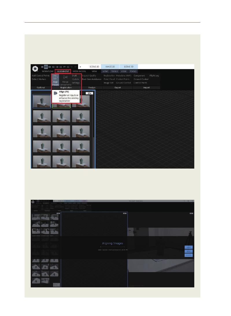
58
To align the photos by selecting [Align Images] in the [ALIGNMENT] tab at
the top left. Point cloud data is generated with the data imported through this
process.
When the photos are matched, the progress time and completion time are
displayed as shown below. Through this operation, the images are matched.
5) Running the
Alignment of
Images
6) Alignment of
Images
<Figure 5> Clicking Align Images
<Figure 6> Aligning Images
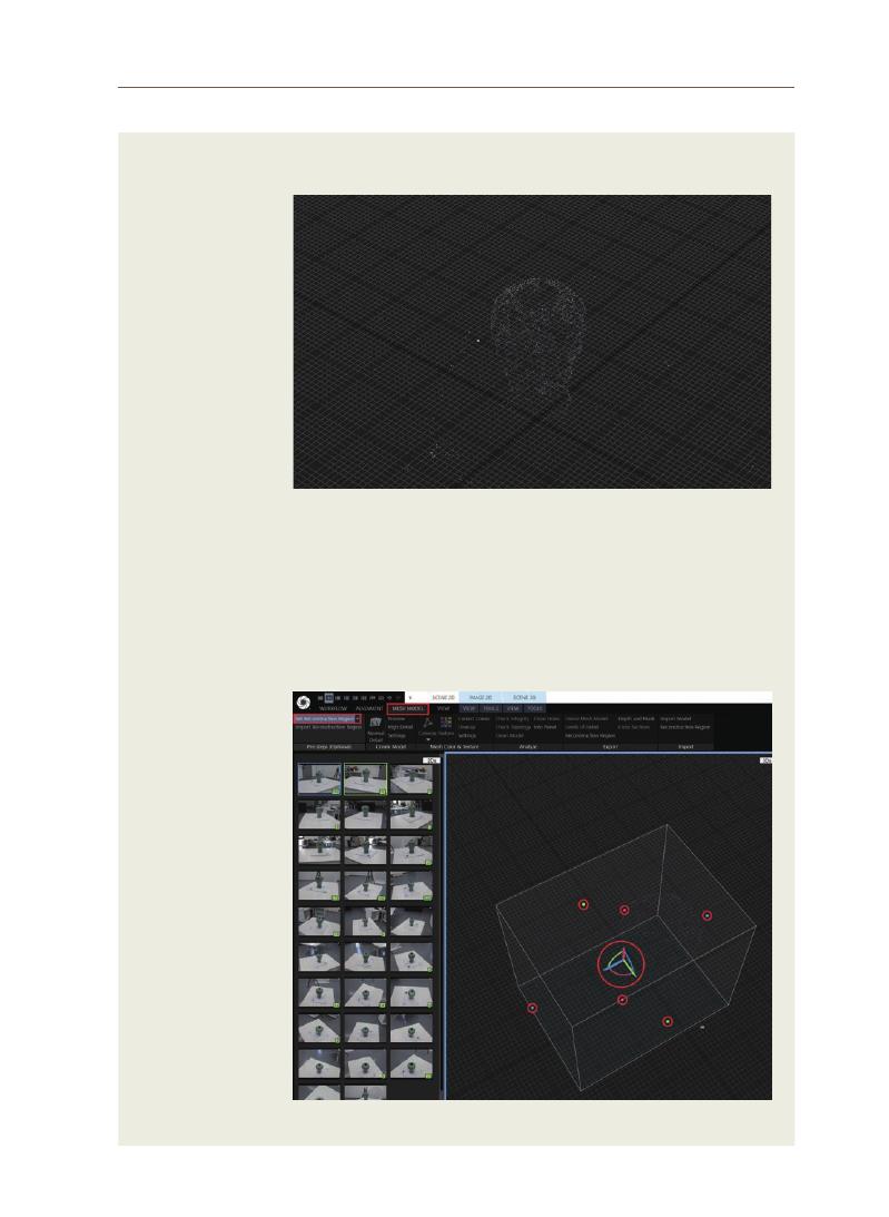
59
Jong
-w
ook Lee
8) Setting modeling
area
7) Generation of
Point Cloud
Data
Point cloud data are generated as shown in the picture below.
To click [Set Reconstruction Region] in the [MESH MODEL] tab at the top left
to open a box where you can select a modeling area. As shown in the picture
below, you can set the size of the box with 6 small folds and rotate the model
through the large coordinate system in the middle. The white box indicates
the area to be modeled finally.
<Figure 7> Generated Point Cloud
<Figure 8> Selecting Modeling Area

60
When the ground plane is arranged, a box centered on the artifact is formed
as follows
To select [Normal Detail] from the [MESH MODEL] tab in the upper left. This
operation generates mesh data.
<Figure 9> Point cloud data with ground plane arranged
<Figure 10> Click Normal Detail
9) Completion of
Ground Plane
Arrangement
10) Running Mesh
Generation

61
Jong
-w
ook Lee
11) Mesh
Generation in
Progress
12) Generation of
Mesh Data
When mesh generation is in progress, the progress and completion times
are displayed as shown below. This operation generates mesh data.
As shown in the figure below, a mesh with no texture is generated.
<Figure 11> Generation of mesh data
<Figure 12> Generated mesh
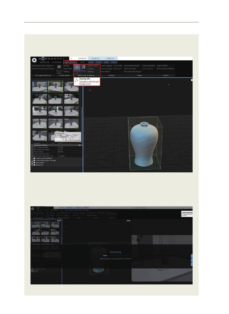
62
To click [Colorize] from the [MESH MODEL] tab at the top left. This gives the
mesh a color.
When coloring mesh is in progress, the progress and completion times are
displayed as shown below.
<Figure 13> Clicking colorizing
<Figure 14> Coloring mesh in progress
13) Coloring Mesh
14) Coloring Mesh
in Progress
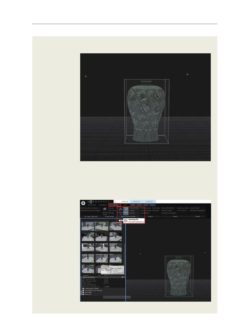
63
Jong
-w
ook Lee
15) Generation of
Colored Mesh
Data
16) Running
Texture
Mapping
Colored mesh data are generated as shown in the figure below.
To click [Texturing] in the [MESH MODEL] tab at the top left. This operation
maps the texture to the colored mesh.
<Figure 15> Colored mesh
<Figure 16> Clicking texturing
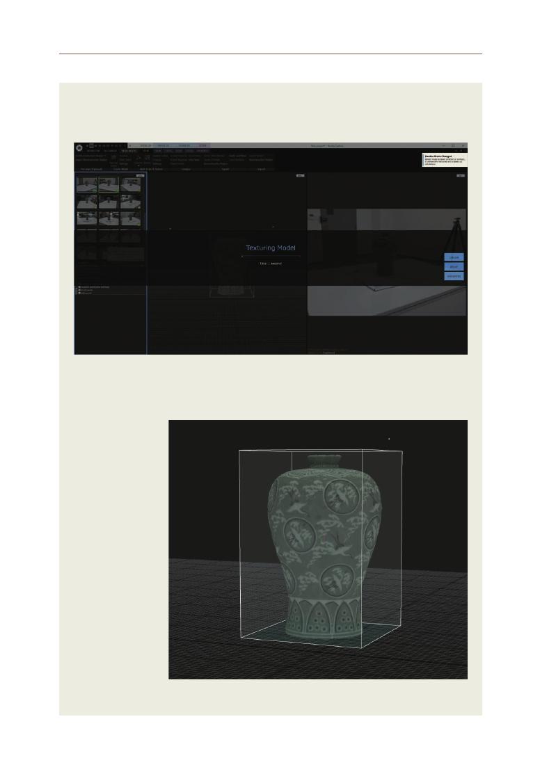
64
<Figure 17> Texture mapping in progress
<Figure 18> Texture-mapped model
17) Texture
Mapping in
Progress
18) A Texture-
mapped Model
When texture mapping is in progress, the progress and completion times
are displayed as shown below. The texture is mapped through this operation.
As shown in the figure below, a texture-mapped model is generated
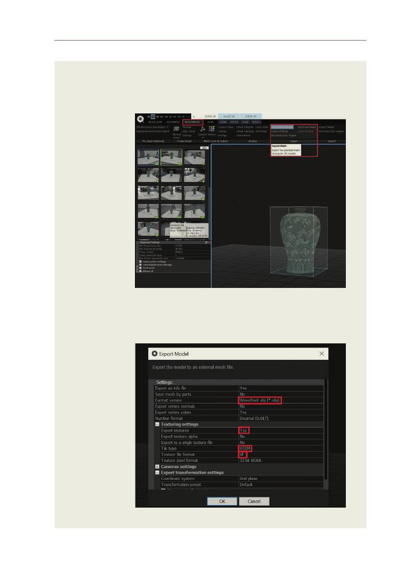
65
Jong
-w
ook Lee
19) Exporting
Modeling Data
20) Setting up Data
Format
To click [Dense Mesh Model] in the [MESH MODEL] tab at the top left. The
mesh and texture data generated through this operation are exported to
a file.
When exporting the model, select the path to save and set up the format
as follows
<Figure 19> Clicking Dense Mesh Model
<Figure 20> Setting up data format
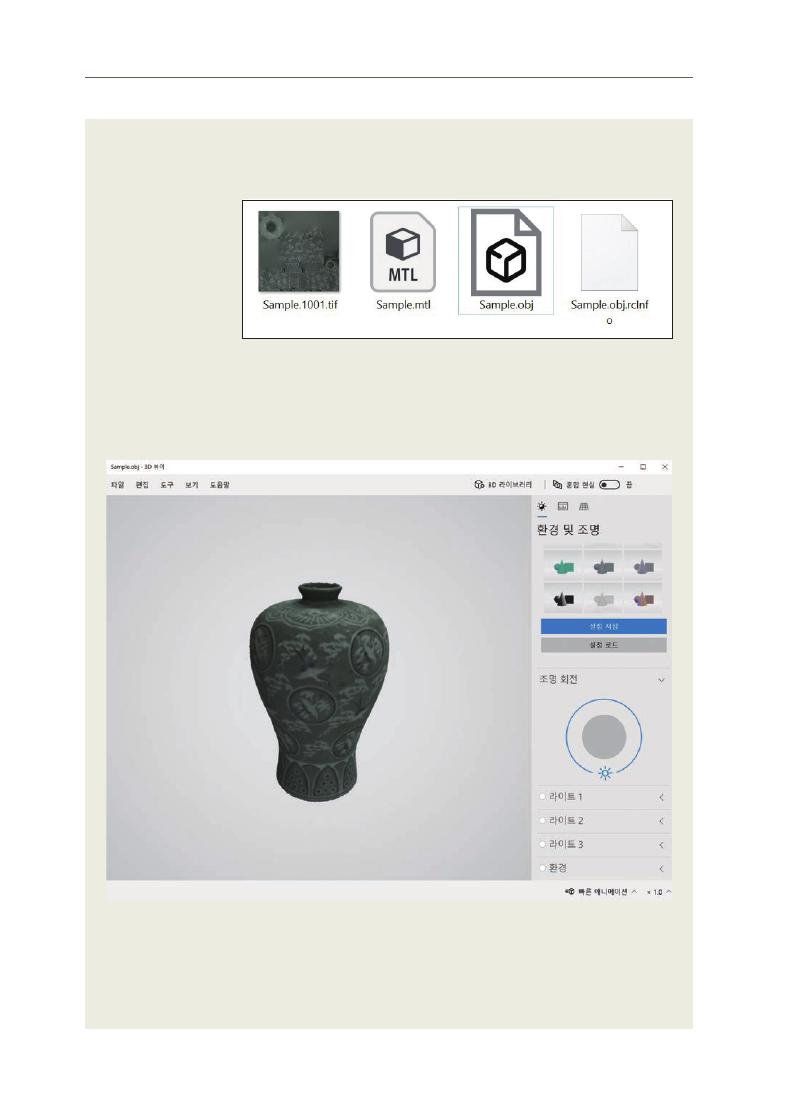
66
To go to the selected path and check the exported file. The tif file is a texture
one, and the obj file is a modeled mesh one.
To utilize the generated data by creating content.
<그림
20> 데이터 포맷 설정
<Figure 21> Generated obj, tif, mtl files
<Figure 22> 3D Goryeo celadon viewed through a 3D viewer
21) Check of the
Exported File
22) Utilization of
the Generated
3D Data

67
Jong
-w
ook Lee
Appendix 2. Glossary
– Aperture
: A small and often narrow opening, especially one that allows light into a
camera.
– Image sensor
: A component that detects the strength and color of an optical image and
converts it into digital image data, and is an electronic component for
image storage, transmission, and playback.
– ISO
: The standard that defines the sensor sensitivity to light as per the
International Organization for Standardization (ISO)
– Macro lens
: A type of lens that can capture a subject closely because the focal length
between the subject and the lens is short
– Mesh
: A method of digitally representing a surface using line-connected points
to define a large number of small polygons (typically triangle or square).
– Point cloud
: A set of points in a 3D coordinate system used to represent the surface
of a subject.
– SfM (Structure from Motion)
: A technology such as a photogrammetry skill that constructs a 3D
structure of an object by grasping 2D images and information generated
as the object moves.
– Shutter speed
: The length of time the camera shutter is open.
– White balance
: The process of neutralizing the color of reflected light and adjusting the
color balance when shooting with a camera.

02

Survey Research Papers on
UNESCO Chair Research Grant
The 'Sense of Place' Creation through Cultural and Architectural Preservation of
Timber Construction of Malay Mosque Architecture
Case Study: Chepor Raja Mosque, Lenggong, Perak, Malaysia
Azizi Bahauddin, Mohd Jaki Mamat
Investigating the Significance of Toponym to the Outstanding Local Values of
Heritage Places for the City’s Cultural and Economic Competitiveness
Eko Nursanty
Preservation and Historical Study of Early Architectural Drawings and
Pictorial Records of Heritage Buildings in Seremban, Malaysia
Kum Weng Yong, Doris Hooi Chyee Toe
Outstanding Universal Value of George Town, Penang: Surviving Covid-19
Lim Yoke Mui, Khoo Suet Leng
Trace Relationship between Revered River and Sacred Settlements
Morphology in South India: Case of Kaveri River in Context of South Karnataka
Monalisa Bhardwaj, Sudha Kumari G
Traditional Use of Lacquer in Cambodia
Vanna LY

This study focuses on the unique features of the architecture of Malaysia’s
Chepor Raja Mosque in Lenggong, Perak, using the theoretical framework of
“
sense of place” and the creation of “sacred places” through its architectural
and cultural heritage. These factors are based on interrelated elements of
Islamic religious beliefs. A an important sacred symbol of Islam, the typology
of the humble Malay mosque architecture demonstrates strong cultural
and architectural heritage. However, presently, the mosque architecture in
Malaysia is mostly dominated by monumental domes and towers - two non-
local elements that have replaced the local ones, thereby altering the official
expression of Malay mosques. Consequently, the mosques lack a local sense
of place. To fill the research gap regarding Malay mosque architecture, this
study uses the conceptual framework of sacred places through the creation
of a sense of place. The Chepor Raja Mosque was constructed over 400
years ago, when Sufism began to spread. Its spatial planning demonstrates
simplicity in architectural scale and the use of localized timber construction
conveys a traditional image. The mosque also demonstrates the value of
hybrid assimilation through Hindu-Buddhist syncretism and tolerance,
indicating the Nusantara hybridization of the Malay and Javanese architectural
styles and cultural heritage. This research employs qualitative methods of
phenomenological and case study approaches and architectural documentation
analysis to emphasize the symbolic and semiotic aesthetics in the construction
of sacred spaces through the local sense of place. Ultimately, Chepor Raja
Mosque’s sense of place was established through various cultural influences
and architectural components.
Sense of place; sacred places; mosque architecture; cultural and architectural
heritage
Azizi Bahauddin Professor and Lecturer, Universiti Sains Malaysia
Mohd Jaki Mamat Senior Lecturer, Universiti Sains Malaysia
The 'Sense of Place' Creation through Cultural and
Architectural Preservation of Timber Construction of
Malay Mosque Architecture
Case Study: Chepor Raja Mosque, Lenggong, Perak, Malaysia
Abstract
Survey Research Papers on UNESCO Chair Research Grant
01
Keywords
71
Azizi Bahauddin
Within mosque architecture, producing the structures required to create
a “sacred place” requires an understanding of Islam. The Quran and hadiths
provide detailed information on designing appropriate spaces for house
activities. The term mosque, also known as Bayt Allah or the house of God
(
Baitullah),
conveys the idea of a house meant for worship and religion, whose sole
owner is God (Allah). The concept of Baitullah further confirms that the Ka’aba
(
Haram Mosque)
in Mecca and the Al-Aqsa Mosque in Jerusalem were the first
global contributions to Islamic architecture (Othman, 2015). The Ka’aba became the
Qibla (the direction of prayers toward the Ka’aba) for Muslims’ tawhid (belief in the oneness
of Allah)
around the world for more than 15 centuries. The Ka’aba represents a
universal concept that encompasses and overcomes one’s whole life and the
hereafter (Bakar, 2008). Praying towards the Ka’aba while performing ritual
purifications is one of the key practices of Sufism. These rituals include
dhikr (rhythmic repetition chants in the name of Allah), prayers, zakat (giving alms), and
recitation of the Quran and Tawaf (circumambulations of the Ka’aba). All these rituals
are tied to the path of the Nubuwwah (prophethood), which includes performing
Umrah (the non-mandatory lesser pilgrimage) and Hajj (the greater Muslim pilgrimage to
Mecca),
the fifth pillar of Islam. In reference to the Ka’aba architecture, the value
of the philosophy of tasawwuf (the process of realizing ethical and spiritual ideals) goes
beyond the boundaries of reasons and feelings. This is because of the Ka’aba’s is
supposed to contain answers to the question of reality.
1-1 Problem Statement
All sacred places require an understanding of the concept of sense of place.
Based on Le Lefebrve’s spatial triad theory, comprising “conceived,” “perceived,”
and lived” spaces, we argue that the sense of place in Malaysia’s mosque
architecture serves to establish it as a “sacred space.” That is, the cultural and
architectural heritage embedded in a mosque strengthens the creation of the
sacred spaces based on local traditions and the architectural components of
1. Introduction
Figure 1. Chepor Raja Mosque

72
the mosque. However, the mechanisms through which this sense of place is
created in reference to the sacred spaces within Malaysia’s mosque architecture
has not been examined in depth. Therefore, to fill this gap, this study applies
the theoretical framework of sense of place to Chepor Raja Mosque, Lenggong,
Perak (Figure 1), as a research setting, whose characteristics are relevant to the
aims of this research. For instance, it exhibits the elements of local vernacular
mosque architecture and provides opportunities to analyze the role of these
features in creating a sense of place through the spatial planning of the sacred
spaces found within its architecture and compound.
1-2 Justification for the Case Study:
• Lenggong, where the Chepor Raja Mosque is located, is associated with the
Old Malay Perak kingdom and UNESCO-listed Lenggong valley, which is a
relevant historical factor influencing the mosque’s sense of place.
• The mosque’s building materials were sourced from the iron ore mining
industry surrounding the Lenggong area, although its jointing systems
were constructed out of timber.
• The mosque follows the unique Perak architecture style with a multilevel
pyramidal roof system.
• In terms of its setting, the mosque is surrounded by rivers and greenery,
which allows the worshippers’ emotional experience to be well immersed
in their religious beliefs while contributing to the creation of its sense of
place.
1-3 Perak State
The Perak state had undergone many religious influences in the past, but
the people who brought along these religious beliefs were still the Malay people.
The state predominantly followed animistic beliefs before the arrival of the
Hindu–Buddhist influence. Buddhist beliefs were the main belief system during
the Srivijaya Kingdom (7th–12th centuries AD), while Hindu beliefs appeared in the
Malay Peninsula in the 12th–15th centuries AD and peaked during the Majapahit
Kingdom rule. Islam came to the Malay Peninsula in the 14th century and has
been the the main religious belief in Malaysia since then. Many theories have
debated the influence of these religious beliefs and the people who have brought
them to Malaysia. However, the influences of these beliefs are apparent in the
simple details and ornamentations of the Chepor Raja Mosque, and the creation
of its sense of place and sacred place.
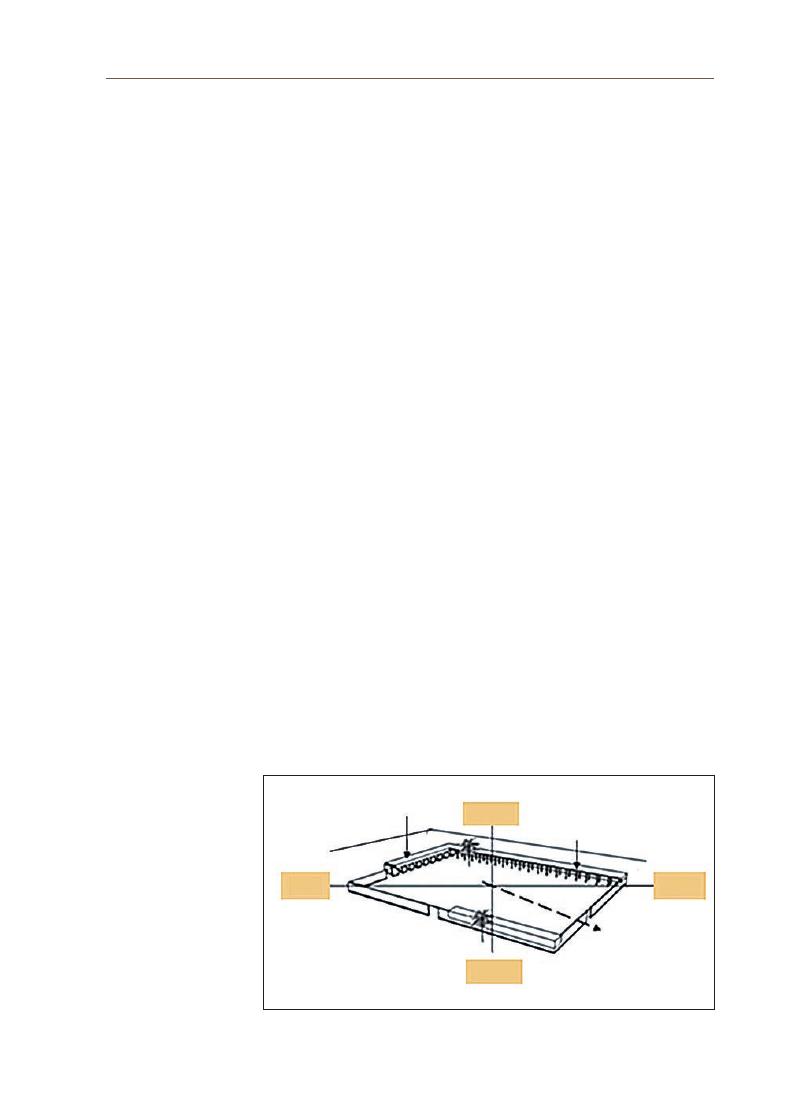
73
Azizi Bahauddin
1-4 Research Objectives
This study aims to (i) examine the architectural components of the mosque
architecture of Chepor Raja Mosque that contributed toward the construction
of its sense of place based on spatial triad theory; (ii) analyze the architecture of
Chepor Raja Mosque to understand the relationship between the spatial triad
and sacred spaces; and, (iii) construct the sense of place of this mosque based
on the Sufistic beliefs and the creation of the sacred places based on the spatial
triad.
One of the major problems in the discourse of Islamic architecture is
the relevance of the idea of a “style” as opposed to the more fundamentalist
approach of vernacular revivalism or the radical approach of interpreting the
Sunnah of the Prophet Muhammad (Peace be upon him (PBUH)). In the context of
architectural theory and history, one must establish the latter to derive ideas
from the former. Historical descriptions and classifications are the building
blocks of architectural theory. In architecture, theory is used as an approach
to design. Most importantly, mosque architecture embodies the teachings of
Islam while simultaneously producing a sense of place. This sense of place is
further enhanced by the construction of sacred places to complement all the
religious activities that occur within vicinity of the mosque. At the beginning of
the Prophet’s (PBUH) life, before the Hijrah year, the mosque was not a special
building or a specific architectural work.
Physically, the early building of the Masjid Nabawi (the Prophet’s Mosque)
(
Figure 2)
was a rectangular building constructed using mud brick construction
methods. The building had four walls and three protected areas. The roofs were
2. Mosque
Architecture
Figure 2. Masjid Nabawi Complex, Madinah (Creswell, 1968)
South
Al-Bayt
Al-Suffah
Qiblat
North
East
West

74
supported by posts made of palm tree trunks. The first part of the roof protected
the main space on the wall facing the Qibla. The second closed part to the left of
the main hall was intended to protect the house of the Prophet Muhammad (PBUH)
and his wives. The other side of the roof was in front of the mosque where the
Sufis (Al-Suffah) spent their nights. These were poor but educated immigrants.
They learned from Prophet Muhammad (PBUH) and served him.
2-1 Sense of Place
Sense of place is a subjective perception based on the physical characteristics
of a place and involves cognitive and perceptual factors in a sense of time
(
Hashemnezhad, Heidari & Hoseini, 2013),
(Najafi & Shariff, 2011; Scannell & Gifford, 2014).
Through the passage of time, the sacredness of a place develops, and becomes
intimately tied to the sense of authenticity of that place (Birch & Sinclair, 2013;
Mazumdar & Mazumdar, 2004).
According to the theoretical perspective of the
spatial triad, the formation of sense of place is affected by the (i) “perceived”
spaces/spatial practices, (ii) “conceived” spaces/representations of space, and (iii)
“
lived” spaces/representational spaces (Lefebvre, 1991). In a traditional building,
the perceived space refers to the physical character of the building that helps
develop its sense of place based on its historical form, cultural characteristics,
and functional setting (Ali, 2019). Architectural design, symbols, iconography,
and artifacts are essential to any religion. As a subset of culture, religion affects
people’s attachment to a sacred place, which includes a space that is purposely
created to uphold the basic concept of religion and acts as a mediator for
experiencing faith (Gojnik & Gojnik, 2019a). The rich cultural values and meanings of
a sacred place, particularly in traditional architecture, enable the community to
form a place identity. The Chepor Raja Mosque offers a base for investigating the
concept of sense of place’ for attributes based on this theory.
2-2 Sacred Places
In the context of Islamic religion, haptic experience is defined by the presence
of the tactile elements of the sacred place, such as touching the ablution water
and the praying mat. To fulfil the criteria of the sacred place, the believers must
touch the tactile elements of this space and participate in the transcendent to
complete the experience of faith. The element of smell through the olfactory
sense also contributes to the experience of a sacred place. Building materials
have their own distinctive smell, which characterizes the place. In terms of
sound, each sacred space has different degrees of silence and echo. It is believed

75
Azizi Bahauddin
that hearing creates a connection to the place, as well as to the Supreme Being,
as shown in the call to prayer/azan and the recitation of the Quran. Another
experiential aspect of Islamic sacred places is the visual element. The design
and décor of sacred structures also help to create a sense of place and bring
worshippers into religious ideals. Building ornaments, calligraphy, the Qibla
compass, images of Ka’aba in Mecca, and other sacred cities also function as
place artifacts, which are visual reminders that solidify one’s tangible physical
connection to a place. Hence, sacred places involve several dimensions of
sensory experiences that interact and fuse to form a sense of place (Gojnik &
Gojnik, 2019a; Mazumdar & Mazumdar, 2004; Pallasmaa, 2012).
As a place of worship,
the Chepor Raja Mosque and its unique sense of place is the best example for
understanding the meaning of sacred places.
This study uses descriptive qualitative approaches, especially in the context
of phenomenology, to obtain accurate and systematic information regarding the
characteristics and values of the architecture of the Chepor Raja Mosque and the
construction of its sense of place. According to Groat and Wang (2013), qualitative
methods help researchers interpret the meanings behind symbols and forms.
This study began by comparing the early documentation of the mosque’s
evolution and observing the typology of this mosque and the construction of
its sense of place. These observations also focused on the overall composition
of the mosque space contained in the hybrid components of some mosque
architectural design styles. However, this study concentrated only on the more
dominant components, such as the appearance of the roof, prayer room, porch
space, ablution space, and azan tower. It also involved several surveys of the
architecture and the sense of place, analysis of architectural documentation
and secondary sources from the authorities, and a review of the history and the
philosophy of the mosque. Architectural documentation was strengthened by
visual data that helped validate the positioning of the mosque’s architectural
components and spatial planning.
Architectural documentation is critical for understanding the design of
mosque architecture planned for the Chepor Raja Mosque. This includes
acquiring the exact measurement of the mosque and space planning that was
designed for the mosque.
3. Methodology
4. Architectural
Documentation

76
4-1 Site Orientation and Layout
This mosque is located on the main road of Chepor Village (Figure 3) in
Lenggong District, Perak. The strategic location of this mosque provides an easy
access to the congregation, as it is located on the main road of Kampung Chepor.
The surrounding verdant provides the mosque with cool air at all times (Figure
4).
Furthermore, the open-space plan of the mosque has already maximized
the natural cross-ventilation in the interiors of the mosque. These conditions
further enhance the coexistence of mosques with the environment. The sacred
ambience created for the believers is another component of the mosque as
a sacred place, and to some extent, many believers believe that the mosque
uplifts their spiritual level to make their worshipping experience full of humility
towards Allah. The strong connection between sacred places and the theoretical
framework of a sense of place of perceived, conceived, and lived spaces depict
the narrative of the Chepor Raja Mosque. Ultimately, the “lived” space of the
mosque is experienced with respect to the spirituality emanating from absorbing
Islamic religious teachings and performing rituals. Each of the spatial triad
concepts come together to form a sacred place.
4-2 Site Survey and Measured Drawings
The measured drawings were taken over a period of two weeks, which
included an analysis of the site and the mosque’s location.
Figure 4. Chepor Raja Mosque Environment
Figure 3. Chepor Raja Mosque Location Plan
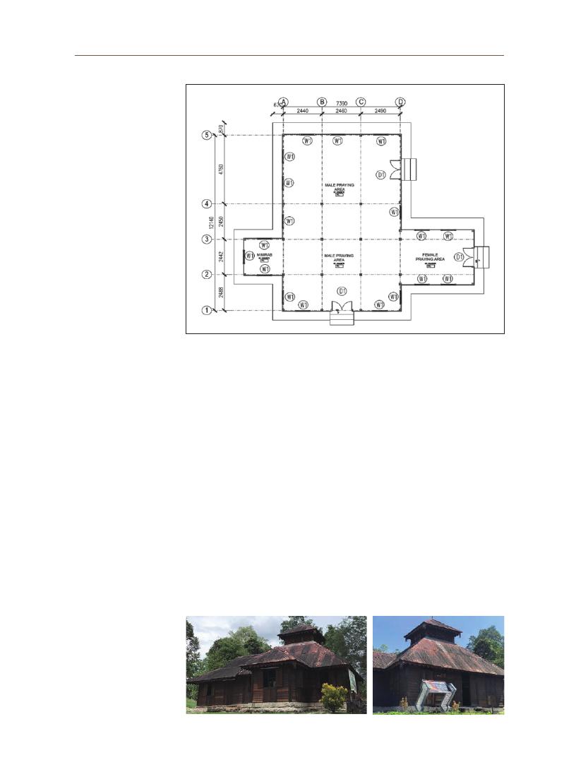
77
Azizi Bahauddin
4-3 Floor Plan
The shape of the mosque has been influenced by the architecture of
the Malaysian archipelago, with symmetrical motifs applied to the building,
especially in terms of the building facade. The original structure was made
of wood with gable walls and a zinc roof. This mosque has undergone five
renovations, and in the third change, the board walls were replaced with a betel-
roof arrangement and a zinc roof. The mosque’s rectangular shape allows the
space to be further expanded for additional prayer rows for the congregation,
and is added accordingly for a sequential and tidy arrangement. Masjid Raja
Kampung Chepor has a floor area of 109 m² (Figure 5). The building space
includes the Imam’s room (pulpit), men’s prayer room, and women’s prayer room.
The layout of the mosque space is centered on half of the men’s prayer room,
Figure 5. Chepor Raja Mosque Floor Plan
Figure 6. The Unique Chepor Raja Mosque Perak Roof

78
which lies in the original building of the mosque. This mosque has additional
space on the right side of the men’s prayer room for the increased number of
male worshipers.
4-4 Building Components
The Chepor Raja Mosque is designed according to the concept of a layered
five-fold roof, known as the joglo roof, owing to its multistory roof. The design
of the mosque is influenced by the architecture of Sumatera, which can be
seen in the design of its layered roof (Figure 6) called bumbung limas bungkus,
which is said to have originated from the Netherlands and Britain. This type of
architecture was first introduced in the Riau archipelago in the 17th and 19th
Figure 7. Chepor Raja Mosque Left Side Elevation
Figure 8. Chepor Raja Mosque Right Side Elevation
Figure 9. Sections
Figure 10. Mihrab
Figure 11. Chepor Raja Mosque
Female Praying Room
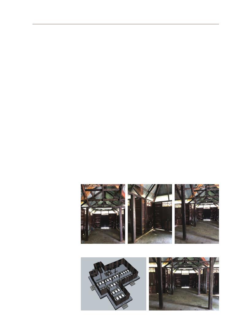
79
Azizi Bahauddin
centuries. There is a ventilation space in the middle covered by “louvers” to let
the hot air out and replace it with new air.
As this mosque has gone through five major changes, the use of the roof has
also changed due to age factors. The previous use of roofs was believed to be
thatched or nipah roofs. However, its use has been replaced by zinc (Figure 7 and 8),
which is more durable and provides greater protection to consumers.
The roof design of the building, which is influenced by this traditional design,
simultaneously applies Islamic values to the multi-story roof. The use of a
multistory roof in the central part of the mosque is supported by four main pillars
(
Figure 9).
The use of the four pillars in the mosque symbolizes the four sects
that are practiced and held in Islam. Windows are among the most important
elements because they can influence and control the quality of ventilation and
lighting in a house. The size and type of materials used vary according to the
function of the space in which the window is placed. Similar to doors, windows are
also places where cross-ventilation takes place. Windows were built during wall
construction. Window frames were installed and placed in vacated spaces on the
wall. Steel anchors were used to strengthen the window positions on the wall.
4-5 Interior Space Planning
Figure 12. Open Space Planning for the Creation of the “Sacred Spaces”
Figure 13. Interior Space Configuration
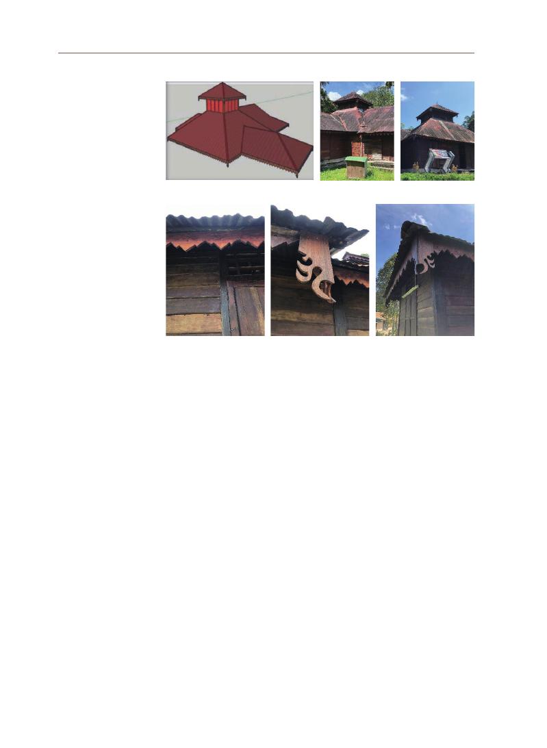
80
The Chepor Raja Mosque has only three spaces: the mihrab (the wall in the
mosque that indicates the Qibla)
room (Figure 10), the main prayer room, and the
women’s prayer room (Figure 11). The construction for the floor of this building
is a concrete type of floor, and only one type of finish is used in different spaces.
In the main prayer room, women’s prayer room, and pulpit space, a carpet-
type floor finish is used, which also serves as a prayer mat for the congregation.
The short parts of the mosque’s building, such as the main prayer room and
the women’s prayer area, are oriented from east to west (Figures 12 and 13). The
long part of the building that houses additional prayer and ablution spaces faces
north and south orientations. Therefore, the space is blocked by the glare of the
sun rising from the east.
4-6 Detailing / Traditional Furnishings / Ornamentations
Every design and element of the mosque has some intriguing features. The
construction of this mosque also has an interesting history that should be known
to the public so that the knowledge about this mosque continues to last and
can be utilized to construct its sense of place and sacred places. Being one of
the oldest mosques in the region, and in Southeast Asia, this mosque is deeply
Figure 14. Pyramidal Roof
Figure 15. Roof Eaves –
Bamboo Shoot
Figure 16. Lizard’s Tail Roof Fascia Board

81
Azizi Bahauddin
embedded in Islamic teachings. The pyramidal roof (Figure 14) carries Hindu-
Buddhist influences. For example, the roof can be related to Mount Meru or
the stupa, whereas in Islamic belief, a pointed roof indicates the relationship
between humans and God. In any belief, a pyramid roof highlights the connection
between humankind, the environment, and divine power, such that the
humankind must understand the environment to understand divine power.
However, the traditions of Malay people from various religious beliefs can be
observed in this humble architecture of the Chepor Raja Mosque. Details such as
the roof eaves (Figure 15) reflects the teaching of behaviors in communities, while
the fascia board in the lizard’s tail (Figure 16) design indicates respect for nature
in terms of the fauna as a part of the environment and the beauty of lizard as a
small creature.
As a sacred place, the mosque not only functions as a place of worship, but
also functions as a monumental display in the form of a landmark showing
the ruling authority in the conquered land. Its architectural forms are diverse
according to the influence of the local traditions, regional characteristics of its
geographical location. The non-confessional use of its space is also a significant
part of the local inhabitants’ raison d’être (Baharudin & Ismail, 2014). In addition, as
religious institutions, mosques are built as platforms for social bonding. Hence,
the concept of communal or jamek mosques has evolved since the early era
of Islamic development. In other words, mosques are a prominent space for
community socialization as well as for daily religious activities (Jaffar Harun &
Abdullah, 2020; Gutiérrez, 2018).
For Muslim believers, the mosque is an essential
element in their lives that creates strong emotional ties based on the religious
experiences and memories that are built over time, in which a sense of place is
formed. The sense of place within a mosque’s architecture is based on Islamic
teachings and offers the worshippers the experience of the sacred places
through its architectural style and components and the cultural factors that
house the mosque. This experience is further strengthened by Islamic teachings
in terms of communities and environmental education, as demonstrated by the
surroundings of the mosque. The Chepor Raja Mosque epitomizes the creation
of “sacred places” despite its modest appearance. The sense of place in the
architecture of the Chepor Raja Mosque has been created by the preservation of
the various cultural influences and architectural components of the mosque. The
religious beliefs of the communities surrounding the Mosque and its heritage
5. Conclusion

82
all contributed to the development of the sense of place in the Chepor Raja
Mosque by sustaining its cultural wellbeing and respecting the environment.
The established sense of place in turn enhanced the creation of the mosque
as a sacred places, as found in its architectural details and space planning.
These characteristics reflect the principles followed in earliest mosque
architecture during the Prophet Muhammad era, when the design of the
mosque space included big open spaces supported by other spaces meant
for communal activities. The new knowledge of the establishment of the
sense of place in the Chepor Raja Mosque can be further extended to
other heritage mosques in Malaysia, and could serve as a benchmark for
preservation activities in other religious institutions in a way that validates
their sense of place.

83
Azizi Bahauddin
References
Ali, S. A. The Contributions of Traditional Architecture to Sense of Place:
A Study of the Traditional Hotels of Fremantle. Curtin University. (2019).
Baharudin, N. A., & Ismail, A. S. Communal Mosques: Design functionality towards the
development of sustainability for community. Procedia - Social and Behavioural
Sciences, (2014).153, 106–120.
Bakar, O. Pengaruh globalisasi terhadap peradaban. Jurnal Peradaban-
Jurnal Rasmi Pusat Dialog Peradaban, Universiti Malaya, (2008). 1(1), 1–16.
Birch, R., & Sinclair, B. R. Spirituality in Place: Building Connections Between
Architecture, Design, and Spiritual Experience. (2013). ARCC 2013: The Visibility of
Research, 80–87. Retrieved from http://www.academia. edu/download/31096320/
ARCC2013_UNCC_Conference_Proceedings.pdf#page=98.
Creswell, K. A. C. A Short Account of Early Muslim Architecture II. (1968). Oxford:
Clarendon Press.
Gojnik, Z. S., & Gojnik, I. Landmark phenomenology of sacred architecture as cultural
heritage. Urban Book Series. Springer International Publishing. (2019a).
https://doi.org/10.1007/978-3-030-10612-6_20.
Gojnik, Z. S., & Gojnik, I. Space as Symbol in Sacred Architecture. The Problem of
Christian Sacred Architecture. Resource Proceedings, (2019b). 2(3), 136.
https://doi.org/10.21625/resourceedings.v2i3.638.
Groat, L., & Wang, D. Architectural Research Methods. New Jersey: John Wiley and Sons
Ltd. (2013).
Gutiérrez, C. G. The Role and Meaning of Religious Architecture in the Umayyad State:
Secondary Mosques. Arts, 7(63), 144–150. (2018) https://doi.org/10.3390/
arts7040063
Hashemnezhad, H., Heidari, A. A., & Hoseini, P. M. “Sense of place” and “Place
Attachment.” International Journal of Architecture and Urban Development, 3(1),
5–12. (2013).
Jaffar, N., Harun, N. Z., & Abdullah, A. Enlivening the mosque as a public space for social
sustainability of traditional Malay settlements. Planning Malaysia, 18(2), 145–157.
(
2020). https://doi.org/10.21837/pm.v18i12.750.
Lefebvre, H. The Production of Space. Oxford: Basil Blackwell. (1991).
https://doi.org/10.4324/9781315446486-34.
Mazumdar, S., & Mazumdar, S. Religion and place attachment: A study of sacred places.
Journal of Environmental Psychology, 24(3), 385–397. (2004).
https://doi.org/10.1016/j.jenvp.2004.08.005.
Najafi, M., & Shariff, M. K. B. M. The concept of place and sense of place in architectural
studies. World Academy of Science, Engineering and Technology, 80(8), 1100–1106.
(
2011). https://doi.org/10.5281/zenodo.1082222.
Othman, R. Menelusuri Jejak Kegemilangan Wakaf: Di Mana Peranan Pentadbir. In
Perkongsian Amalan Terbaik dalam Pengurusan Universiti. Serdang. (2015).
Pallasmaa, J. The eyes of the skin. Architecture and the senses (Third). West Sussex:
John Wiley & Sons, Ltd. (2012).

84
Scannell, L., & Gifford, R. The Psychology of Place Attachment. In R. Gifford (Ed.),
Environmental Psychology: Principles and Practice (5th ed.). Optimal Books. (2014).
This research was funded by the 2021 UNESCO Chair Research Grant Project of the Korea
National University of Cultural Heritage.
The measured drawings were produced by students of Politeknik Ungku Omar, Ipoh, Perak.
Other facilities were provided by the School of Housing, Building and Planning, Universiti
Sains Malaysia, Penang.
Acknowledgements

85
Azizi Bahauddin

The heritage value of a place is marked by its uniqueness that can be
recognized for a long time. Space will change to a place when the messages
sent or the meaning entrenched by catalysts is well received by the surrounding
and spread out both in quantity and quality to a broader context. The spread of
the message and meaning is often reflected in the naming of a place is called
Toponymy. This study used the historic city of Surakarta (or Solo) in Indonesia as
a case. The qualitative methods and an ethnographic approach are employed
for the data collection. The mapping technique is using the photographic method
by fiend study, combined with direct and virtual interviews. The initial research
has found some essential elements of a creative place or city, such as (i) value
and uniqueness of a place that many people realize; (ii) catalysts' superior ethos
and ability to instil inspirative messages to the community from one to the
next generations, and (iii) the superior creative production that able to sustain
competitiveness and to grow the local economy for a long time. The synergy
between these elements is embedded in the "Outstanding Value" that can be
preserved, nurtured, and developed as a valuable heritage. The purpose of
the proposed research is to investigate the origin, meaning, expressions, and
implications of a name to a place uniqueness, the Outstanding Local Values of a
local historical place, or the Outstanding Universal Value of a globally significant
place
city identity, city DNA, toponym, local OUV
Eko Nursanty Lecturer, University of 17 Agustus 1945 (UNTAG) Semarang, Indonesia
Investigating the Significance of Toponym to the
Outstanding Local Values of Heritage Places for the City's
Cultural and Economic Competitiveness
Abstract
Survey Research Papers on UNESCO Chair Research Grant
02
Keywords

87
Ek
o Nur
santy
“
Geographical names as cultural heritage,” is a statement that affirms the
study of the names of geographical places (toponyms) as significant as it is part
of the national culture. Toponyms are part of the local culture that cannot be
separated from human impressions of the place. A place’s name is a juncture
where language, culture and human thoughts or impressions meet. The study of
toponyms will help in tracing the geographical conditions, environmental factors,
linguistic diversity and local history of a place.. In fact, in some countries with
unstable administrative conditions, toponyms have become points of attraction
that enhances local geopolitics. Some of these aspects make toponyms an
interesting subject to be studied further (Segara, 2021).
Space and time are fundamental elements in the dimensions of human
perception that organize the experiences that one goes through (Leidner, 2008).
Consequently, all documents and narratives regarding various artefacts are
related to the human experience of space and time-frequency. Toponymy is
the study of place names, their origin and history. It is a field that has hardly
been recognized by geographers, psychologists, architects and philosophers
who have written about places and their spirits. However, the understudied field
of toponymy influences various other fields of study concerning places, roots,
dwellings, attachments, openings, throwntogetherness, boundaries and sense of
place.
According to the research conducted by Deroy and Mullen, place names
should be simple and to the point (e.g., money denominations, such as Dollar or Euro),
so that they don’tdistract people from their daily utilitarian activities. They
serve as geographic abbreviations that help us find our way around the world
and are indispensable for communication because they eliminate the need
for complicated descriptions. Place names are taken for granted hence, their
importance as symbols of specificity is largely ignored by those who wish to
contemplate places on a more abstract level. (Wang et al., n.d.).
The traditional toponymic approach is to study place names. It delves mostly
into etymology, archives, and local history in order to uncover the meaning of
place names. However, it does not take into account the naming process. Many
Anglo-European place names may not have much of a story to tell and only
appear as descriptions understood by the local people. Nevertheless, it gives
individuality to a place and sometimes have broader connotations. In some
cases, the spelling of the names would have changed over the centuries.
Some place names sum up the narrative, although the meaning is not
always clear or not known. Place names can be influenced by historical events
1. Introduction

88
or incidents and can reveal obscure origins that is invaluable to historians,
archaeologists and so on. Place names can serve as a means to remember
the geography of the place and reinforce traditions and cultural memories.
For example, when anthropologist Basso asked a native American Apache,
“
What is wisdom?” the answer was: “Wisdom sits in places.” For Apache, place
names have stories associated with them that can be used to teach their own
community members and to inform others and convey correct behavior (Feld and
Basso, p56).
Basso referred to this as “living topographic ethnography.”Toponyms
involve more than classification and delving into etymological origins. It also
plays an essential role in ensuring consistency in spelling and usage, overseen
in most political jurisdictions by legally constituted councils or committees. For
example, the UK has a Permanent Committee on Geographical Names. The US
Council on Geographic Names, a federal council, was created in 1890, and the
Council on Geographic Names was formed in Canada, in 1897.
This study investigates the significance of toponyms to the outstanding
local values (OLV) of heritage places for the city’s cultural and economic
competitiveness. The OLV can be used for protection and conservation of the
local identity and significance and to develop policies and management systems
rooted in local history, identity, and traditions. Toponym, in this case, can be
regarded as an “intangible DNA” of a place that generates a sense of rootedness
and pride and gives a reason to defend as well as promote the place’s identity or
“
place branding.”
The reasons for selecting Surakarta in Central Java, Indonesia, as the
case study in this research are: as follows: i) Continuation of a previous study,
“
Formulating the ‘Local HUL’ Instrument for Community Based Cultural
Heritage Management in the Historic Urban Core of a Medium City – with
Semarang and Solo in Indonesia as Case Study,” supported by the 2020 Korea
National University of Cultural Heritage UNESCO CHAIR Research Grant, ii)
Familiarity and accessibility to the city, places, communities, expertise and
resources, and iii) The history and significance of the city.
Surakarta, better known as the City of Solo in Indonesia, was founded in
1745 and is a part of the Islamic Mataram Kingdom, which was established two
centuries ago in 1586 (Wirutomo, 2014). “Sala” was one of the three hamlets chosen
by Sunan Pakubuwana II on the advice of his officers (Tumenggung Hanggawangsa,
Tumenggung Mangkuyudha)
and the commander of the Dutch troops, J.A.B. van
Hohendorff, when he was about to build a new palace, after the Mataram
2. Surakarta
as the Case
Study
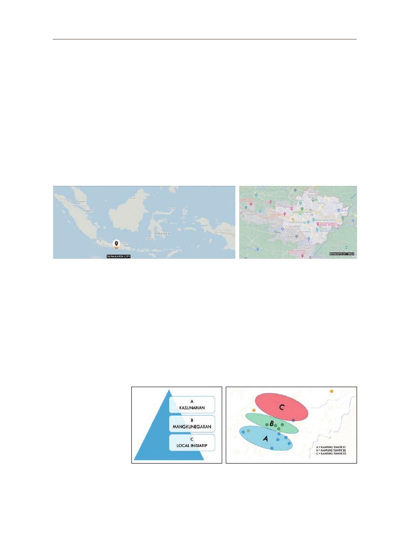
89
Ek
o Nur
santy
succession war took place in Kartasura (Prayitno, 2007).
The official name of the place is “Surakarta,” while colloquially it is known
as Sala or Solo. The name Solo carries with it widespread cultural connotations.
The word “sura” in Javanese means “courage” and “karta” means “prosperous”;
thus named in the hope that Surakarta becomes a place where its inhabitants
will dare to fight for the good and prosperity of the country and the nation. It can
also be said that the name Surakarta is Kartasura in reverse, the name of the
older capital city before it moved to Sala. Sala used to be the name of the village
where the new palace is located. It is named after Shorea Robusta, a sacred tree
of Indian origin.
As a historical city, Surakarta can be divided into three main domains: (A)
Kasunanan—the King’s ( “Sunan” in Javanese) palace area, (B) Mangkunegaran—
the prince’s residential area and (C) the Local Initiatives Area—the urban
development area outside the two areas A and B that was developed after the
city of Surakarta became part of the Republic of Indonesia and was no longer
part of the Surakarta Kasunanan Kingdom.
Figure 1. a)
The position of the city of Surakarta on the island of Java; b) the city of Surakarta or Solo. Source:
Author’s analysis, 2021
a)
b)
Figure 2. a). The social and cultural hierarchy b) The socio-cultural hierarchy of the
geographical area. Source: Author’s analysis, 2021
a)
b)

90
The research uses grounded theory to gauge the relationship between
community members and the toponym. Grounded theory intends to generate
theories about phenomena from the context (Creswell, 2013, Pidgeon and Henwood,
2003).
The purpose of grounded theory is to explain the everyday experiences
of the people involved. However, it must also be sufficiently abstract and
comprehensive to apply to other situations where the phenomena are
experienced (Strauss & Corbin, 1990). Grounded theory begins with a literature
review, followed by the formulation of the theory from the context through
comparison with other existing theories.
a. Sampling
Qualitative research is aimed at developing a theory through an iterative process
of analysis-sampling progressive cycle. This study targets a specific urban
settlement population by selecting a manageable subset of the population.
Theoretical sampling is the process of data collection whereby the researcher
collects, codes and analyzes the data on the basis of which they determines what
information is to be collected next and where to find it in order to develop the
theory as it emerges (Glaser and Strauss, 1967). The systematic sampling method
aims to select information-rich cases for an in-depth study. Effective sampling
strategies that change during data collection and analysis enable the researcher to
complete the task with minimal waste and without entering any conceptual blind
alleys to produce an excellent grounded theory (Bryant & Charmaz, 2007).
The sampling was carried out at two levels: a) selection of localities at the urban
level and b) selection of respondents within each locality. In this study, the localities
or “kampungs” were selected based on the historical growth of the city (time
factor) and the hierarchy of space functions (social-cultural factors).
b. Data Collection
The data were collected using three methods: A structured questionnaire that
included the following components: a) personal background (age, gender), b)
localities (city & kampung), c) length of residency (attachment to place), d) familiarity
with places and local products (place impression), e) production and consumption
Figure 3.
a). The image of the Kasunanan area b) Mangkunegaran area c) The image of the village mural
created as part of a community initiative. Source: Author’s analysis, 2021
a)
b)
c)
3. Research
methodology

91
Ek
o Nur
santy
(
need, possession, appeal), f) catalyst and locus (familiarity, identity).
Photography & Videography observation: Direct and comprehensive on-site
observation over a prolonged period of time could not be carried out owing to the
COVID-19 pandemic safety regulations and limitations. An expert photographer
or videographer, who is also a cultural anthropologist, was employed to capture
the relationship between people and places by observing their social, cultural
and economic activities. Interview validation: Validation was conducted through a
structured interview that allowed the researcher to gain the richness of information,
the possibility of probing and the depth of reasoning through the “why” questions.
Figure 4.
Questionnaire prepared using Google Forms. Source: Author’s
analysis, 2021

92
c. Data Analysis
The analysis involved two iterative processes: a) Coding, an interpretive technique
that organizes the data and provides a means to introduce its interpretations
into specific quantitative methods. The analyst demarcates segments within the
data and labels them with a ‘code’, a word or short phrase that is the gist of that
segment, or introduces concepts that the researcher considers relevant to the
research objectives. Data can be precoded (the process of assigning codes to
expected answers), field-coded (the process of assigning codes during fieldwork)
or postcoded (the process of assigning codes after fieldwork). The coding process
can be divided into two steps: 1) basic coding to distinguish overall themes, and 2)
in-depth interpretive coding, in which more specific patterns and trends can be
interpreted; and b) Categorization, where the completed codes are clustered into
categories based on function, time, meaning, setting and similarities. Categories
that frequently emerge and appear to relate to other categories would be selected
for further analysis. The interpretation of the categories is further analyzed and
validated through interviews. The subsequent interview may reveal additional
categories that trigger an iterative process for re-analysis. Relevance of the
categories may change as the study progresses and if some categories are found
not to have explanatory value, they will be omitted from further analysis. At the end
of the iteration process, some categories would be merged and divided into several
parts. This is the dynamics of the categorization process.
Overall, in this study, we clustered the emergent codes based on similarities
in meaning and function and categorized them. Subsequently, these categories
were reviewed and rectified several times. Later, the organization changed
by comparing and combining codes and categories from other parts of the
interview and other interviews. As a result, some categories were merged and
some were divided into two or more parts in order to draw results from the
analytical process.
This research is mainly concerned with the practical possibilities of analyzing
urban toponyms and their interpretation, which may be of interest to the
multidisciplinary fields of sociology, history and geography. Our aim is to verify
that the names of streets, squares or parks in the city’s historical center serve as
indicators of official points of view and ideological impressions of political, social
and historical events in the context of heritage cities on the island of Java. This
study analyzes the current road network of the historical center of Surakarta
City. We will attempt to define the fundamental trends in the process of the
vocabulary of streets. At the same time, we will pay attention to their thematic
focus. Toponym research aims to determine the intensity of local, regional,
4. Result and
Analysis
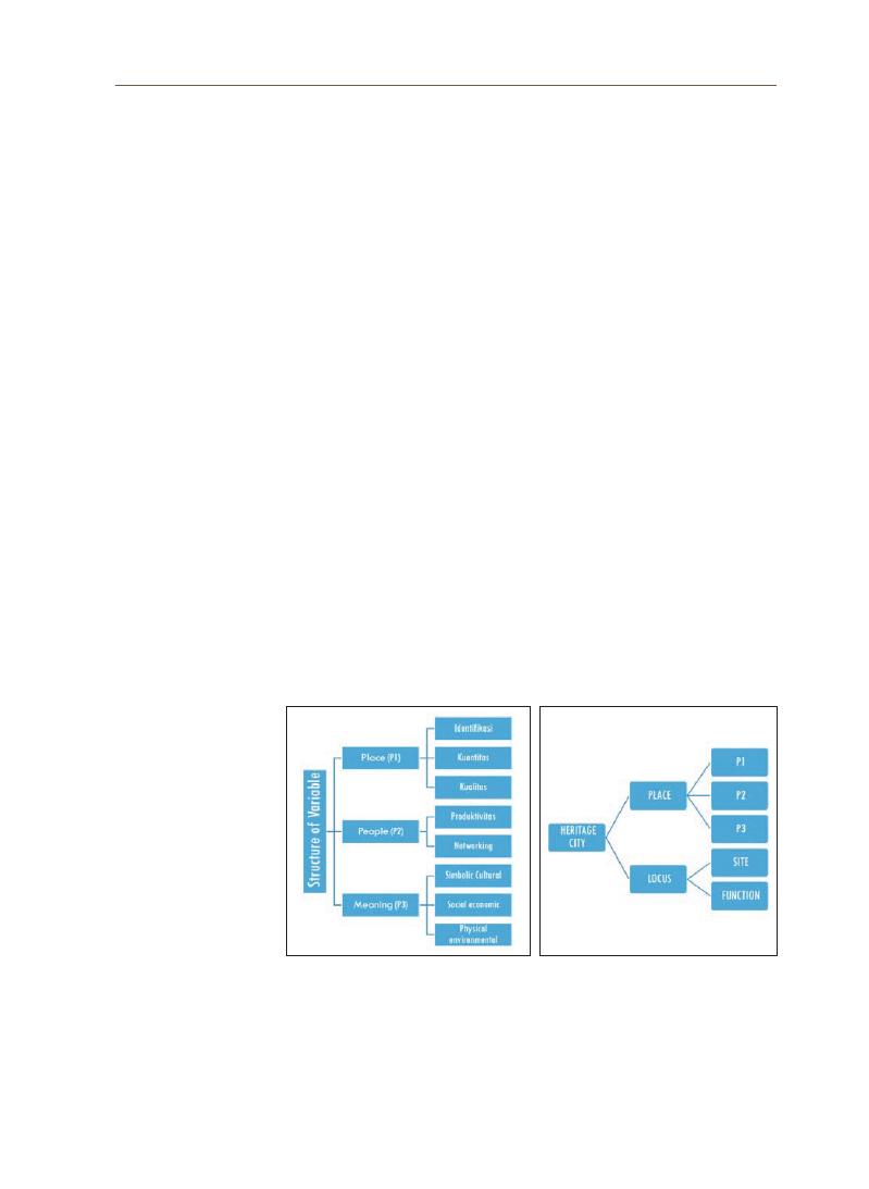
93
Ek
o Nur
santy
and national identities, based on geographical research, in the city’s historical
center’s model area through place names, street names and squares. (Radding,
2010).
Determining geographic interpretations of place names or toponyms
involves resolving various types of ambiguity. Place names usually occur in
lists and data tables. Authors often omit qualifiers (such as city or state containers)
for place names, because they expect the meaning of individual place names
to be evident from the context. We present a new technique for place name
disambiguation (also known as toponym resolution) that uses Bayesian inference to
assign categories to lists or tables containing place names and then interpret
individual toponyms based on the most likely category assignment. Categories
are nodes in a hierarchy along three orthogonal dimensions: type of place (city,
capital city, river and so on),
geographic container and prominence (by population and so
on)
(Adelfio, 2013).
4-1 Place mapping
Publicly well-known places in Surakarta are currently dominated
by 14 thematic villages with three main structures: seven villages in the
Kasunanan heritage area, five villages in the Mangkunegaran heritage area
and three villages in the urban development area outside the Kasunanan and
Mangkunegaran areas.
Figure 5. Structure of the research questions and the findings. Source: Author’s
analysis, 2021

94
4-2 People mapping
The grouping in the above section is closely related to the formation of the
characteristics of the communities in each area. The main activity of the people
in the Kasunanan area (A) is serving the interests of the Kasunanan Kingdom,
both in terms of economics and religion. At the peak of the Surakarta Kasunanan
Kingdom, the king was not only considered a government leader but also a
religious leader.
Interim compilation of data collected from respondents of the questionnaire
(
around 30% of the targeted respondents)
till August 31, 2021, is presented below. A
detailed explanation and interpretation of the statistical findings are presented
after this interim report.
Figure 6.
Seventeen popular village names in Surakarta Source: Author’s analysis (2021)
Figure 7. Samples of people’s activities in areas A, B, and C. Source: Authors, 2021
95
Ek
o Nur
santy
96
5. Mapping
Place, People,
Culture and
Meaning
Toponymic
thematic
mapping
Meaning
analysis
Area's
strength
structuring
People
EXPERTISE
E + P +
HISTORY
PATRONAGE
Popular Crafts
Royal Crafts
Place
ANALYSIS-PLACE NAMING STRUCTURE
OLV=Outstanding Local Value
D=NEW NAMING
97
Ek
o Nur
santy

98
References
Acknowledgements
Adelfio, M. D., & Samet, H. (2013, November). Structured toponym resolution using combined
hierarchical place categories. In Proceedings of the 7th workshop on geographic
information retrieval (pp. 49-56).
Bryant, A., & Charmaz, K. (2007). The Sage Handbook of Grounded Theory: SAGE Publications
Ltd.
Corbin, J. M., & Strauss, A. (2008). Basics of Qualitative Research: Techniques and Procedures
for Developing Grounded Theory: Sage Publications, Inc.
Corbin, J. M., & Strauss, A. (2008). Basics of Qualitative Research: Techniques and Procedures
for Developing Grounded Theory: Sage Publications, Inc.
Creswell, J. W. (2013). Research Design: Qualitative, Quantitative, and Mixed Methods
Approaches: Sage Publications, Incorporated.
Creswell, J. W. (2013). Research Design: Qualitative, Quantitative, and Mixed Methods
Approaches: Sage Publications, Incorporated.
Glaser, B. G., & Strauss, A. L. (1967). The Discovery of Grounded Theory: Strategies for
Qualitative Research: Aldine de Gruyter.
Leidner, J. L. (2008). Toponym resolution in text: Annotation, evaluation and applications of
spatial grounding of place names. Universal-Publishers.
Prayitno, B., & Qomarun, Q. (2007). Morfologi Kota Solo (Tahun 1500-2000). DIMENSI
(
Journal of Architecture and Built Environment), 35(1), 80-87.
Radding, L., & Western, J. (2010). What’s in a name? Linguistics, geography, and toponyms.
Geographical review, 100(3), 394-412.
Segara, N. B. (2021, March). Toponym investigation as introduction to the local value in Cirebon
City. In IOP Conference Series: Earth and Environmental Science
(
Vol. 683, No. 1, p. 012014). IOP Publishing.
Speriosu, M., & Baldridge, J. (2013, August). Text-driven toponym resolution using indirect
supervision. In Proceedings of the 51st Annual Meeting of the Association for
Computational Linguistics (Volume 1: Long Papers) (pp. 1466-1476).
Strauss, A., & Corbin, J. (1990). Basic of Qualitative Research. Basic of qualitative research.
Strauss, A., & Corbin, J. (1990). Basic of Qualitative Research. Basic of qualitative research.
Wang, X., Zhang, Y., Chen, M., Lin, X., Yu, H., & Liu, Y. (2010, June). An evidence-based approach
for toponym disambiguation. In 2010 18th International Conference on Geoinformatics
(
pp. 1-7). IEEE.
Wirutomo, P. (2014). Sociological reconceptualization of social development: With empirical
evidence from Surakarta City, Indonesia. Asian Social Science, 10(11), 283.
Ye, X., Gong, J., & Li, S. (2021). Analyzing Asymmetric City Connectivity by Toponym on Social
Media in China. Chinese Geographical Science, 31(1), 14-26.
This research is funded by the 2021 UNESCO Chair Research Grant Project of the Korea
National University of Cultural Heritage.

99
Ek
o Nur
santy
TIME TABLE OF RESEARCH
Please indicate the activities to be conducted during the research period.
Month
Activities
Outputs
May
Preparations:
1. Consolidation of resources
2. Detailing working plans
• Working plan (finished)
June
Inventory:
1. Collecting data (archives, literature, records)
2. Interviewing respondents (patrons, experts, artisans, community,
visitors, etc.)
• Working plan (finished)
July
Inventory & analysis:
1. Continuation of inventory process (as above)
2. Synchronic & diachronic analysis
• Working plan (finished)
August
Analysis & report writing:
1. Continuation of analytical process
2. Additional fieldwork & interviews
3. Progress report writing
• Working plan (finished)
September
Presentation & formulation:
1. Drafting research progress report paper
2. Consolidation of analytical findings
• Draft of research
presentation
October
Formulation & writing:
1. Presenting research progress report paper
2. Writing the manuscript for journal publication
• Research Progress
Report Presentation
November
Publication:
1. Finalizing manuscript for journal publication
2. Writing final report
• Research Paper for
The Journal of Korean
Cultural Heritage
December
Final report:
1. Writing final report
2. Final report submission
• Final Report

In architectural conservation work, early records of the buildings are
essential references to know the original design, authenticity of the building
elements and periods of transformation or changes to the buildings. These early
records can be in the form of architectural drawings, photographs and other
pictorial records as visual records are directly useful in architectural work. This
research aims to preserve, digitally archive and conduct historical study of early
architectural drawings and pictorial records of heritage buildings in Seremban,
Malaysia. Based on availability and accessibility to the records for restoration
and digitization, this research utilized two long scrolls of architectural drawings
which present the site plan of the large railway station yard in Seremban from
the British colonial period. The two drawings measured approximately 400 cm
(
length)
by 75 cm (width) each before restoration and physically they are one whole
site plan when placed together. It is estimated that the drawings were produced
between 1936 and 1951. The historical study emphasized the significant heritage
values of the site, in terms of commodity transportation including tin and rubber,
that linked Seremban to the maritime trade route via Port Dickson since 1891.
Hence, the site was the core of economy, movement and society in Seremban.
Compared to other early maps of Seremban Town covering the period from 1893
until 2016, this set of site plan drawings provide the finest details of the Seremban
Railway Station Yard in terms of the organization pattern of the railway tracks
and facilities, two-dimensional building block-plans and their block numbers
or tenant names, and the land and building utilization. This implies that the site
plan drawings are an invaluable source of historic information to understand the
allocation and distribution of railway-related activities and functions on the site in
the past, and the drawings are worth preserving.
Kum Weng Yong Principal Architect and Conservator, KW Yong Architect, Seremban, Malaysia Associate Member, Disaster
Preparedness and Prevention Centre, Malaysia-Japan International Institute of Technology, Universiti
Teknologi Malaysia, Kuala Lumpur, Malaysia
Doris Hooi Chyee Toe Senior Lecturer, Faculty of Built Environment and Surveying, Universiti Teknologi Malaysia, Johor Bahru, Malaysia
Member, Disaster Preparedness and Prevention Centre, Malaysia-Japan International Institute of Technology, Universiti
Teknologi Malaysia, Kuala Lumpur, Malaysia
Preservation and Historical Study of Early Architectural
Drawings and Pictorial Records of Heritage Buildings
in Seremban, Malaysia
Abstract
Survey Research Papers on UNESCO Chair Research Grant
03

101
Kum W
eng Y
ong
In architectural conservation work, early records of the buildings are
essential references to know the original design, authenticity of the building
elements, and periods of transformation or changes to the buildings (National
Heritage Department, 2017).
These early records can be in the form of architectural
drawings, photographs, and other pictorial records, as visual records are directly
useful in architectural work. Yeoh (2021) stated that a city without old buildings is
like a person without memory. Hence, early architectural drawings and pictorial
records can help retain the memories of a city and are extremely useful for
carrying out accurate conservation works.
Malaysia is situated in the southernmost part of mainland Asia and has
been an important center for the maritime Silk Road since ancient times. It
functioned as an essential location for the amalgamation and exchange between
Eastern and Western cultures. Since the 19th century, the country was colonized
by the British, seeing advancements in various modes of transportation, and
subsequently became the Eurasian trade route. As the frequency of cultural
exchanges increased, this naturally fostered the flourishing of colonial
architecture, rich with multiple influences in the country (Chen, 1998).
Nevertheless, many developing cities do not possess proper and complete
archives of their heritage buildings, including those in Malaysia. For example,
the Public Works Department of Malaysia is yet to organize an archive of
architectural drawings and building records of government buildings in the
state of Negeri Sembilan, where Seremban is located (Public Works Department,
Negeri Sembilan, 2021).
The record is so fragmented that very few early drawings
of heritage buildings are still in the department. The factors behind this
could be the damage caused by the war in 1941–1945, the keeping of Malaya
government records in Singapore when it was the main administrative center,
and their relocation by the British (or in certain cases destruction) after Malaya
gained independence. Architectural drawings thus become precious artifacts for
preserving the histories of postcolonial cities. In the context of postcolonial cities,
the modern heritage of the 19th and 20th centuries is particularly vulnerable
because of their weak legal protection and low appreciation (van Oers and
Haraguchi, 2003).
Presently, “Demolish and Build” (Meroboh dan Membina Semula, in
Malay)
projects are more commonly found than conservation projects on sites
with old buildings in Malaysia (Yeoh, 2021). Ironically, due to a lack of historical
records and studies, heritage buildings with historical value are easily dismissed
as insignificant (Goh, 2021). The bulk of professional architectural education and
practice is heavily focused on large-scale new developments, instead of heritage
1. Introduction

102
conservation (Yeoh, 2021).
The scarcity of early architectural records and other factors have led to the
abandonment of many heritage buildings in historic urban cores and contributed
no solution to conserve them. Seremban, Malaysia, is a serious example.
According to Idid (1995), Seremban town had 446 pre-war buildings, which
amounted to 45% of the Negeri Sembilan state’s total of 999. The inventory
pointed to the importance of heritage conservation in Malaysian towns; however,
no further effort was made to preserve the architectural records. In fact, there
were more than 70 sites comprising more than 100 units of abandoned and
dilapidated pre-independence buildings, some in states of disrepair, damaged
by fire, or demolished, including railway facilities in the heart of Seremban town
in 2018. Unlike world-renowned cities such as Kuala Lumpur, George Town
(
Penang)
and Melaka, serious preservation work in Seremban is still rare.
This research project aims to preserve, digitally archive, and conduct a
historical study of early architectural drawings and pictorial records of heritage
buildings in Seremban, Malaysia, as references for architectural conservation
work. The objectives are (1) to find a suitable technique for the restoration and
digitization of early architectural drawings and pictorial records, and (2) to
conduct a historical study to identify the dates of the records and understand the
history of the records and buildings. This paper discusses findings based on the
two stated objectives.
2-1 Description of the Selected Drawings
The main objects for restoration in this project are architectural drawings
in paper form. For this purpose, we inquired at the Public Works Department,
Negeri Sembilan, which is responsible for the construction and maintenance
of public infrastructure in the state of Negeri Sembilan for access to early
architectural drawings. The Public Works Department was established by the
British government during the colonial period and housed drawings concerned
with the planning, design, and construction of public heritage buildings. However,
our inquiry discovered that there was no proper archive of architectural
drawings and building records in the department and our request for access
was denied; even on-site viewing was not possible for the few drawings kept due
to improper storage and other reasons. We also looked for early architectural
drawings and pictorial records at non-profit associations and other sites.
Based on limited availability and accessibility to the records, this project
2. Restoration
and
Digitization
of Early
Architectural
Drawings
103
Kum W
eng Y
ong
utilized two long scrolls of architectural drawings that present the site plan of
the large railway station yard in Seremban from the British colonial period (Figure
1).
The drawings were salvaged from the waste at the railway yard. The site plan
is composed of upper and lower parts. The two drawings measured 403.4 cm
(
length)
by 75.5 cm (width) (upper part) and 380.1 cm (length) by 76.3 cm (width) (lower
part)
respectively before restoration, and physically, they composed one whole
site plan when placed together (Figure 2). Based on our inquiry to the National
Archives of Singapore, it was found that several old survey maps of British
Malaya were originally published and compiled in this fashion, that is, smaller
maps covering specific quadrants to make up parts of a larger map, because of
the number of details that needed to be included in the maps (National Archives of
Singapore, 2021).
Hence, the dual site plan drawings adopted a similar map format,
containing fine details of the railway station yard (Figure 2).
2-2 Identification of Paper Restoration Techniques
The nature of the paper used for the plan is fragile. Though it is an important
carrier of cultural heritage, paper will inevitably age and face various damage
issues with the passage of time. Damage by external and internal factors
can deteriorate the quality of the paper and change its original appearance,
information, and value. Therefore, paper restoration work is given primary
importance.
The purpose of paper restoration is to restore documents to their original
appearance and preserve their invaluable information. Paper cultural relics, if
not properly protected for a long time, lose their information and appearance.
For example, the original color might change, and cause difficulty in reading the
information on the paper. Therefore, the principles and requirements of paper
restoration must be carefully followed during the process. This section reviews
two types of paper restoration - the Victorian era map (relatively thick paper) and
Figure 1. Overall view of
the architectural
drawings for
restoration,
digitization and
historical study
used in this
research
Figure 2.
Detailed view of the Seremban Railway Station Yard site plan

104
the ancient Chinese deed (relatively thin paper) and proposes a feasible paper
restoration plan for the architectural drawings in this study.
2-2-1 Principles of Paper Restoration
There are four principles to fulfill the requirements of a good paper
restoration process (Han, 2020).
1) Maintain the paper’s authenticityThe best way of preserving paper cultural
relics in their original state is to preserve all the information of the document.
As stated above, paper cultural relics contain important cultural heritage data.
Hence, the authenticity of the data and the paper condition must be closely
adhered to.
2) Privilege restoration of damaged parts, treatment is supplementary
Restore the severely damaged and important paper documents first, and then
consider restoring the less damaged parts of the paper documents. Additional
treatment can be applied as supplementary to achieve the effect of recovering
the damage.
3) Reversible restoration technique
In the restoration process, the restoration technique may not be mature and
the materials may be used incorrectly, which might cause damage to the paper
cultural relics. Therefore, the restoration techniques and materials used must
be reversible. The use of natural restoration materials such as flour paste and
seaweed gum is recommended because of their reversibility and authenticity.
4) Minimal intervention
In line with the first principle of maintaining authenticity, it is not advisable to
modify the documents by adding and subtracting information. This situation is
encountered, for example, when a portion of the paper is lost, torn, or damaged.
Moreover, the coloring and restoration of calligraphy depend on the damage
conditions.
2-2-2 Identification of Paper Damage Factors and Solutions
Table 1 lists the common types of paper damages, their leading factors,
and the recommended solutions. From the examination of the architectural
drawings used in this research, the Seremban Railway Station Yard drawings
were exposed to all of the paper damages listed in Table 1, except for burn
marks and microbial damage (Figure 2). One of the drawings was incomplete
due to damages caused by mice, while the other drawing was damaged due to
adhesion of the strip tape along the paper edges. The recommended solutions
must be carefully considered, according to the paper storage environment, after
restoration.

105
Kum W
eng Y
ong
2-2-3 Review of Paper Restoration Techniques
There are various types of paper. According to the form of paper, it can be
used for maps and drawings, documents, books, calligraphy and manuscripts,
postcards, newspapers, photographs, certificates, etc. According to the material
of the paper it can be divided into papyrus, hemp paper, vellum paper and rag
paper which are usually made of basic raw materials like linen, cotton rags
and wood pulp. Alternatively, according to the paper-making method, it can be
categorized into handmade paper (mainly practiced before the Industrial Revolution)
and machine-made paper (practiced after the Industrial Revolution) (Cantavalle, 2019).
The selection of the appropriate paper restoration technique depends on the
type and condition of the paper. Different kinds of paper like hemp paper, straw
paper, and rag paper are similar in their production process and the use of raw
Table 1. Damage factors and solutions for paper cultural relics (Source: Adapted from Han, 2020)
Paper Damage
Factors
Factor Description
Recommended Solutions
Water stains
Stains
Wrinkles
Creases
Deformation
Fractures
Incompleteness
Adhesion
Discoloration
Microbial
damage
Blurred writing
Burn marks
Biological
destruction
Mice, microbes and insects will
eat paper; their excrement will
contaminate the relics and become a
site for mold growth.
Use low temperature (-16°C,
24 hours) to freeze insects and
exterminate them; use a refrigerator
or cold storage
Moisture
The increase in humidity of the
environment will increase the
moisture absorption of the paper and
deform it, which is conducive to the
reproduction of microorganisms. Low
humidity will turn the paper hard and
brittle.
Humidity control (monitoring
and controlling the temperature
and humidity of the storage
environment)
Temperature
High temperature will intensify paper
aging; whenever the temperature rises
by 5°C the deterioration rate of paper
cultural relics will increase, increasing
the growth rate of microorganisms.
The transitional low temperature will
cause the moisture in the paper to
freeze and cause structural damage.
Control the storage temperature
(
it should not be lower than the
freezing temperature of the paper)
Air
Acid gases (SO2, H2S, CO2), oxidizing
gases (NO2, CI2, O3) and dust in the
air
Purify the air (reduce acid
gases, oxidizing gases, dust and
microorganisms)
Light
Light has radiant heat which triggers
physical and chemical reactions,
turning the paper yellow and brittle.
Cellulose and hemicellulose will
accelerate hydrolysis under light and
produce sugars which will destroy
the original structure and affect the
strength of the paper; sugars are
microbial food, which makes the
paper moldy.
Light control (reduce ultraviolet rays
and heat from light)
Others
Fire, accident
Store in a safe storage location

106
materials, but the color and thickness are different, which require precautions
during restoration.
A common method used in identifying paper type is to distinguish the era
of the paper based on the information on the paper (document), for example,
pictures or fonts with time-specific characteristics. For undated documents or
if there is a need to obtain a more accurate time of production or publication, the
more scientific method of using apparatus appraisal by Carbon 14 is an option.
Because the architectural drawings used in this research were undated, further
analysis of their date was done based on a historical study in Section 3.3.
As stated above, the paper restoration technique differs depending on the
condition of the paper, but the restoration process is similar. The process is
divided into three stages: preparation, restoration, and completion (Figure 3). The
data collected by taking photographs and recording in the preparation stage
can provide the original information to be retained in case of errors that cannot
be remedied in the restoration process. This is in line with the aforementioned
principles of paper restoration. The main restoration process consists of using
clean water and a small amount of chemical agents to clean the surface and
internal stains of the paper. The next step is to restore the missing parts and
the information on the paper, without compromising the authenticity of the
information. The final process of restoration is reinforcement and stabilization
by adding a small amount of chemical agent to the reinforcing agent (paste)
to stabilize the internal structure of the paper and prevent further damage.
After the restoration work is completed, the paper is photographed again and
recorded information of the restored document is organized, and the final
protective measure is carried out on it for long-term preservation.
The ambient temperature and humidity must be strictly controlled in the
repair room, and the fluctuation range of temperature and humidity should
not be too large, especially during the drying process of the paper after
being supported and strengthened. Otherwise, inappropriate temperature
and humidity may cause mold growth and secondary destruction. Restored
Figure 3.
Steps in paper restoration process
Preparation
1. Taking photographs
2. Recording
3. Experim ents and tests
4. Develop a restoration
plan
1. Cleaning
2. Stabilization
3. Repair
1. Taking photographs
2. Recording
3. Preserve
Restoration
Completion

107
Kum W
eng Y
ong
archives have an increased chance of mold reproduction owing to pasty and
damp conditions. Therefore, the restored paper must be dried and sterilized
before storage. To avoid creating new conditions of damages in the storage, the
restoration room should also be ventilated frequently, kept clean and sanitary,
and the air should be purified regularly. If possible, the environmental indicators
of the restoration room should be kept to a range similar to that of the archive
storage.
The following review focuses on restoration techniques of paper sheets,
including maps, drawings, photographs, postcards, and certificates, which are
suitable for this research. There are differences in restoration techniques for
books and bound documents. Two examples of paper restoration techniques are
presented: one on a Victorian era map, representing relatively thick paper, and
the other on an ancient Chinese deed, representing relatively thin paper.
1) Restoration of a Victorian era map (thick paper) by The University of Iowa
Libraries
This is an example of thick paper restoration. The main reasons for the
map needing restoration were that it was dirty, and aging material needed to be
repaired. Moreover, the primary objective was to separate the historic map from
the acidic cardboard backing and remove the adhesive residue from the paper.
This technique would be useful for the Seremban Railway Station Yard drawings,
which also have adhesion along the paper edges and backing paper in some
parts. The level of damage to the Victorian era map was not serious. Therefore,
it was relatively easy to repair. The sequence of the restoration techniques is
presented in Table 2.
Table 2. Restoration process and techniques on a Victorian era map as an example
of thick paper sheet (Source: Adapted from Butler and Konger Gongzuo Shi, 2020)
Step
Figure
Description
1
The document was
examined to determine
if it would benefit from
washing.
2
The surface was cleaned
with a brush and vulcanized
rubbers.
108
Step
Figure
Description
3
Different types of ink were
tested with alcohol and
water.
4
The pH level of the de-
ionized water was tested
for the bath.
5
The document was sprayed
to help the water soak
through faster.
6
It was dipped gently in the
water with the support of
sheets of spun polyester
for soaking.
7
The backing board softened
and the map could be
separated.
8
The backing board was
pulled away and adhesive
residue was brushed off.
9
The document was pulled
out of the water with
polyester to support it.
10
The map would then be air-
dried and the restoration
was complete.

109
Kum W
eng Y
ong
2) Restoration of an ancient Chinese deed (thin paper) by the China Printing
Museum and Jinyiqiao (Beijing) Wenhua Keji Youxian Zeren Gongsi
The paper in ancient China was relatively thin because of the paper
production process. This paper was old and more difficult to restore due to
its thinness and fragility. There were also patches of missing parts of various
sizes. Restoration by hand was required. Table 3 describes the sequence of the
restoration techniques used for this paper.
Table 3. Restoration process and techniques on an ancient Chinese deed as an example of thin paper sheet
(Source: Adapted from China Printing Museum and
Jinyiqiao (Beijing) Wenhua Keji Youxian Zeren Gongsi, 2021)
Step
Figure
Description
1
The paper deed was moistened with water mist, and tools
such as needle cones and tweezers were used to safely
unfold the folds and curls on the paper.
2
The paper was rinsed carefully with warm water using a
brush to control the water flow and strength to distribute it
evenly on the surface of the paper, remove dust and stains
on the surface, and reduce the acidity of the paper.
3
A clean towel was rolled up and gently rolled on the surface
of the paper to absorb the moisture.
4
The towel was then wrung dry. Steps 3 and 4 were repeated
until the water for cleaning the paper was not obviously
turbid.
5
A transparent plastic sheet was laid on the workbench to
facilitate movement and restoration operations without
causing damage to the paper and to smoothen it out. (This
technique of using a transparent plastic sheet to aid the
paper handling is often necessary.)

110
Step
Figure
Description
6
A cloth was used to further smoothen the paper and plastic.
7
A pre-dyed patch paper was placed on the paper deed
where there were missing parts, and moistened with a
brush to trace the outline shape of the missing part of
the deed. The patch paper was then shaped (hand-torn)
accordingly.
8
Thin paste was brushed evenly on the back of the paper
deed around the area of the missing part, and the patch
paper prepared in Step 7 was pasted evenly at the area.
9
Tweezers were used to tear off the excess part of the patch
paper. A smaller overlap leads to better overall flatness,
ensuring its strength.
10
To fill the smaller holes, a small part of the patch paper
was directly torn off and pasted gently on the hole using
thin paste. The patch paper was selected to fit the actual
condition of the documents. Generally, the patch paper is
of the same or similar material, and the color is similar but
slightly lighter than the document.
11
After all the missing parts were filled with patch paper, a
board strip was pasted with thin paste along the perimeter
of the paper deed in sequence; the long side first, then the
short side. The width of the board strip was approximately
one inch.

111
Kum W
eng Y
ong
Step
Figure
Description
12
After pasting the board strip along the perimeter of the
paper deed, a support paper was placed on the back of the
paper deed. Thin paste was evenly brushed on the back of
the paper, and the support paper was flattened.
13
A piece of absorbent paper was put on the previous papers
to absorb excess water from the paper deed. A brush was
used to drain the water at the same time.
14
After draining the excess water (semi-dry condition), the
paper deed was turned around on its front side. The plastic
sheet on the front side was carefully uncovered.
15
Thick paste was applied on the back of the support paper
along the perimeter edges.
16
For the final drying process, the paper deed along with
the support paper was put on a smooth surfaced wall. The
paper was brushed against the wall, starting at the corner
and keeping in the same direction.
17
After five days, the drying process was finished and the
restoration was complete. This figure shows the ancient
Chinese deed before and after the restoration.
2-2-4 Proposed Paper Restoration Plan
The thickness and fragility of the paper of the architectural drawings used in
this project fall between those of the Victorian era map and the ancient Chinese
deed reviewed above. Based on the two restoration cases studied above, we
proposed to restore the Seremban Railway Station Yard drawings by combining
the techniques, which include cleaning and removing the acidic backing paper

112
and adhesive residue (the Victorian era map case), and handwork-restoration in
patching, strengthening and stabilizing the structure of the paper (the ancient
Chinese deed case).
Moreover, because of the lengths of the site plan drawings,
which are approximately 4 m and considering their storage after restoration,
we proposed to restore the drawing sheets in scroll-type support paper for
convenient roll storage in the future. This technique is similar to that of the
ancient Chinese scroll.
2-3 Actual Restoration and Digitization
Unfortunately, the actual restoration and digitization of the architectural
drawings could not be carried out. The main reason was the closure of
restoration and digitization facilities during the COVID-19 pandemic lockdown
in Malaysia. Interstate travel from Negeri Sembilan (Seremban) to Kuala Lumpur
and Selangor, where such facilities are located, was restricted. Nevertheless,
despite limited physical meetings, we established dialogues with the Centre
for Malaysian Chinese Studies in Kuala Lumpur and other experts in heritage
preservation and digitization.
Another major challenge in the restoration in this research project is the
large size of the paper sheet, particularly in length. The large paper size requires
a flat and smooth work surface, larger than the drawings for the restoration
process (handling and drying). It is also difficult to digitize large drawings owing to
the limitations in the size of the scanning hardware. One option is digitization
using a photographic image (camera technique). Due to these restrictions and
as per the evaluation in the interim report of this project, we progressed to
the historical study (Section 3) in this final report. The actual restoration and
digitization of the drawings will be conducted in the future.
3-1 History of the Sungei Ujong Railway
The Seremban Railway Station was first built as a station serving the Sungei
Ujong railway line, which was inaugurated on July 28, 1891. The 24 miles and
66 chains (approximately 40 km) long railway line connected Seremban and Port
Dickson in Negeri Sembilan, Malaysia (Figure 4). The Sungei Ujong Railway was
one of the three earliest railway lines in Malaysia, which played an important role
in tin transportation from the interior mines to ports along the Straits of Malacca
(
Kaur, 1985).
Among these three earliest railway lines, the Sungei Ujong Railway
line still exists in its entirety, including the station buildings and sites of its two
3. Historical
Study of the
Seremban
Railway
Station Yard

113
Kum W
eng Y
ong
major stations, i.e., Seremban and Port Dickson (Figure 5), and the entire railway
line reserve.
Figure 4. T
he Sungei Ujong Railway line (in red) on partial Map of the States of
Sungei Ujong and Jelebu, 1894 (Source: National Archives of Singapore with
permission of Singapore Land Authority)
(
b) Port Dickson Railway Station.
Figure 5.
Early photographs of the two major railway stations of the Sungei
Ujong Railway line (Source: (a) Old Seremban Furong De Huiyi, 2013; (b) National
Archives of Malaysia)
(
a) Seremban Railway Station

114
It was the only railway line in British Malaya owned and operated by a
private company, which was styled The Sungei Ujong (Malay Peninsula) Railway
Company, Limited and the entirety of the capital investment came from London;
nearly all the subscribers having at some time or other been interested in
the Straits [of Malacca] (Straits Times Weekly Issue, 1891). This reflects the pivotal
position of the Sungei Ujong Railway, including the Seremban Railway Station
in early commodity transportation to the maritime trade route when a large-
scale economy was introduced under British colonization. Its importance is
emphasized further by the railway station yard in Seremban housing nearly all
the railway departments (Section 3.2).
Besides tin, the railway later became a common transportation mode for
other commercial commodities, including rubber (Fisher, 1948; Leinbach, 1975;
Kaur, 1985).
Since 1903, the Seremban railway line has been connected to Kuala
Lumpur in the north (Kaur, 1985). In fact, 1903 was a memorable year in the
history of railway of the Federated Malay States, due to the establishment of
communication from Penang to Seremban (Spooner, 1904). This likely extended
the capacity of the Seremban station and the station was moved to a larger site
(
Figure 6b),
which is the site drawn in the Seremban Railway Station Yard drawings
featured in this research project. The Seremban Railway Station, which was built
in 1903 (Cheah, 2008) is still in use today.
3-2 Periods of Changes to the Site
Figure 6 shows the morphological changes to the site of the Seremban
Railway Station Yard studied in this research project. As shown, the development
of railway facilities at the site increased in general between 1920 and 1953.
Figure 6a shows the earliest map of Seremban Town in 1893-1896. It shows
the earliest railway yard site before moving to the current site in 1903. Even
then, there were station buildings, goods yards, and two buildings for the station
master and railway foreman. The latter might serve as their living quarters,
although this point needs further study. Since the date of this map (1893-1896) is
very close to the opening of the Sungei Ujong Railway (1891), it demonstrates the
significant role of the railway in the early urbanization process of this town, the
history of which could not be separated from the history of its railway. Tin mines
are largely seen in the area that forms the historic urban core of Seremban
today (Figure 6a).
Figure 6b shows Seremban Town circa 1920. The first railway station had
been moved to the present site, leaving a mark of the old diverting railway track

115
Kum W
eng Y
ong
on the 1920 map (Figure 6b). According to the annual report by the Federated
Malay States Railways (1910), the Seremban Station Yard underwent remodeling,
and all works in connection with this item were completed by 1909. It stated that
the line was realigned, both north and south of the signal cabin, and the platform
was widened and brought forward to the main line (Federated Malay States Railways,
1910).
During this period, a preliminary survey of the Seremban to Port Dickson
line was conducted in 1913 to improve the existing railway line as it had heavy
gradients and short excessive curvature (Federated Malay States Railways, 1914) (Figure
4).
It is observed from further reports that earthworks, foundation works, and
basic infrastructure works, including roads and drains, were carried out at the
station yard site from 1918-1924 (Federated Malay States Railways, 1921, 1924, 1925).
This implies that a large station yard site had been acquired and was being
developed, although there were few building block plans in the south of the
railway track drawn in the c.1920 map (Figure 6b).
In Figure 6c, the 1933 map shows a clear boundary of the railway reserve
and railway yard land. It can be seen that the facilities on the site included
goods sheds or godowns, customs, District Railways Engineer’s Office, coal
stage, engine and carriers sheds, railway quarters, and railway coolie lines. A
building of interest to note on this map is the District Railways Engineer’s Office
constructed between 1920 and 1923 (Federated Malay States Railways, 1921, 1924)
(
Figures 6c and 6d).
This building was later turned into the Railway Club with an
adjacent field (padang, in Malay) alongside huge bungalow-style railway quarters
seen in the 1951 map (Figure 6f). This planning layout reflects the provision of
recreational facilities to cater to the social lifestyle of higher-ranking officers.
A noteworthy event in the 1940s was the Japanese occupation (World War II) of
Malaya, which lasted from 1941-1945. Figure 6e was produced by the War Office
in 1945. This means that the map represented the site condition towards the end
of the war or after the war. It remains unknown whether any railway building or
facility at this site was destroyed during the war period. Moreover, some of the
buildings on this site had changed function throughout the years, but there was
less indication of this in the 1945 map. Nevertheless, it is known that railway
transportation remained important to the Japanese during their occupation in
Malaya because the Japanese also needed tin ore, rubber, and steel from Malaya
(
Kaur, 1985).
At the end of the war the notice boards (for train timetables) at railway
stations provided convenient public space for posting printed proclamations to
inaugurate the British Military Administration in Negri Sembilan (Gullick, 2003);
the Seremban Railway Station might have served this purpose as Seremban was

116
the state administrative center.
The development of the Seremban Railway Station Yard probably peaked in
the 1950s, based on the number of railway tracks, buildings, and other facilities
seen on site (Figure 6g). Nevertheless, the level of details in each map might differ,
as they were produced by different offices in different years. For example, the
engine turntable that was erected in 1924 (Federated Malay States Railways, 1925) was
only shown in the 1945 and 1953 maps (Figures 6e and 6g). Rubber godowns are
indicated in the 1953 map (Figure 6g), which shows that the railway was used for
rubber transportation.
Based on a comparative analysis of the site plan drawings discussed in this
study and the other early maps of Seremban Town covering the period from 1893
until 2016 (Figures 6a-j), it can be established that this set of site plan drawings
provides the finest details of the Seremban Railway Station Yard’s organization
pattern of the railway tracks and facilities, two-dimensional building block plans
and their block numbers or tenant names, and the land and building utilization.
This implies that the drawings are worth preserving as they are an invaluable
source of historic information to understand the allocation and distribution of
railway-related activities and functions on the site in the past.
Figures 6h-j present the maps of Seremban Town after Malaya’s
independence in 1957. It can be observed that the Seremban Railway Station
Yard maintained most of the buildings and functions of the 1950s in the 1975 map
(
Figure 6h).
However, further development of the site is not observed thereafter
(
Figure 6i).
In fact, many of the heritage railway structures were abandoned and
demolished, and the site is almost an empty brownfield at present (Figures 6j
and 7).
Considering the historical value of the Seremban Railway Station Yard,
any further demolition of the remaining heritage buildings on the site must
be prohibited. These heritage buildings and the authenticity of the entire
railway yard site must be carefully conserved. It is further recommended that
serious evaluation including Heritage Impact Assessment precedes any future
development. As the site is still authentic despite being abandoned, it gives a
golden opportunity to conserve this gem of the Seremban city and Malaysian
railway heritage.
117
Kum W
eng Y
ong
(
a) 1893~1896
(
b) c.1920
(
c) 1933
(
d) 1936

118
(
e) 1945
(
f) 1951
(
g) 1953
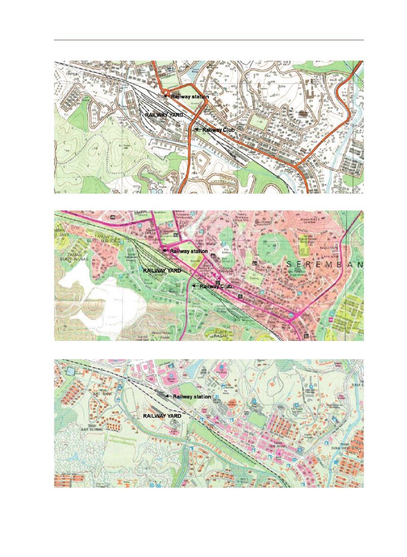
Kum W
eng Y
ong
119
(
h) 1975
(
i) 1993
(
j) 2016
Figure 6. Maps of Seremban town in various years showing morphological changes to the site of the Seremban Railway
Station Yard (Source: (a) Sri Balathandayuthapani Temple, Seremban, 2018; (b) Gullick, 2003; (c, f, g) National Archives
of Singapore with permission of Singapore Land Authority; (d, e) National Archives of Singapore; (h, i) Director of National
Mapping, Malaysia; (j) Department of Survey and Mapping Malaysia)
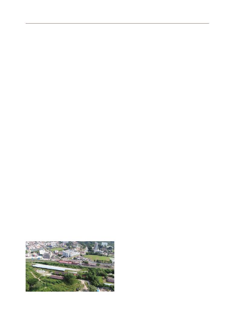
120
3-3 Year Identification of the Site Plan Drawings
The two site plan drawings of the Seremban Railway Station Yard were
undated. In this research project, we inferred the year of production from the
historical study. The characteristics of the site plan indicate that they were drawn
in the style of the British colonial office before the independence of Malaysia in
1957. Further, by referring to the morphological changes to the site in Figure 6, it
is estimated that the drawings were produced between 1936 and 1951. First, as
explained in Section 3.2, the District Railways Engineer’s Office was constructed
between 1920 and 1923. This was indicated by the 1933 and 1936 maps. From
the maps of 1951 until 1993, the same building was labelled as Railway Club. As
the 1945 map does not put any label for this building, the function of this building
between 1936 and 1951 remains unknown. It is interesting to note that the site
plan drawings of this study indicate the same building as a Railway Institute
(
Figure 8a),
which does not appear in any of the maps. Therefore, it is probable
that the building was used as the Railway Institute between 1936 and 1951.
Unfortunately, this building is gone at present.
Second, there are parachute tanks located at the platform along the railway
track according to the site plan drawings of this study (Figure 8b). It is inferred that
the parachute tanks refer to parachute-style water tanks for watering steam
locomotives on the railway line. Steam locomotives were used between 1885 and
1946 in Malaya (Murphy, 1985). In 1946-1957, steam locomotives were replaced
with diesel and diesel electric locomotives (Kaur, 1985). The latter was used at the
Seremban-Port Dickson railway line for heavy-duty traffic (Kaur, 1985). It is likely
that the parachute tanks would be obsolete in later years.
Third, the site plan drawings of this study portray similar organization
patterns of railway tracks and facilities and building block plans, as observed
in the peak development period of the site in the 1950s. It would be noteworthy
to further determine whether the site plan
represents the railway station yard development
before or after the Japanese occupation (World War
I )
in Malaya. This is an interesting point because
the architectural drawings might have survived
the war; otherwise, they might be important
documents used by the British to reconstruct and
improve the site after the war. This ties back to the
possibility of having a Railway Institute at the site.
Figure 7. Aerial view showing the current site conditions of
the Seremban Railway Station Yard, 2021
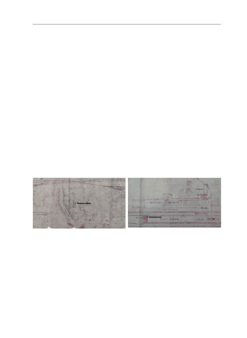
121
Kum W
eng Y
ong
Architectural drawings are essential references for understanding the
history and construction processes of historical buildings. Based on availability
and limitations, this research utilized two long scrolls of architectural drawings
that present the site plan of the large railway station yard in Seremban from
the British colonial period for restoration and historical study. Preserving the
architectural drawings of the Seremban Railway Station Yard site is significant
because they serve as fundamental data for researchers to study not only the
Seremban Railway Station but also the urbanization along the Seremban railway
line and the local history of Seremban.
The historical study emphasized the significant heritage values of this site,
related to the history of commodity transportation, including tin and rubber,
that linked Seremban to the maritime trade route via Port Dickson since 1891.
Hence, the site was the core of the economy, mobility, and society in Seremban.
Due to the comprehensive development of the Seremban Railway Station Yard
and the fine details contained in the site plan drawings of this study, the site
could represent the significant universal values of railway station yards of the
British colonial period. This research project further aims to carry out the actual
paper restoration and digitization of the drawings.
4. Conclusions
(
a) Railway Institute
(
b) Parachute tank at the platform
Figure 8. Partial view of the Seremban Railway Station Yard site plan drawings of this study

122
Butler, M. and
Konger Gongzuo Shi, “Wenwu Xiufu Shiyan Shi Zhi Ditu Xiufu” (Retrieved
August 7, 2021 from <https://www.bilibili.com/video/BV12k4y167Rz/>, June 1, 2020).
Cantavalle, S., “The History of Paper: From Its Origins to the Present Day” (Retrieved
August 10, 2021 from <https://www.pixartprinting.co.uk/blog/history-paper/>, April
5, 2019).
Cheah, J.S., Malaya 500 Early Postcards (Singapore: Editions Didier Millet, 2008).
Chen, V.F. (Ed.), The Encyclopedia of Malaysia, Volume 5 Architecture (Kuala Lumpur:
Archipelago Press, 1998).
China Printing Museum and
Jinyiqiao (Beijing) Wenhua Keji Youxian Zeren Gongsi, “Wenwu
Xiufu-Yinshua Bowuguan Guancang Diqi Xiufu Zhi Lu” (Retrieved August 7, 2021
from
<
https://www.bilibili.com/video/BV1or4y1T7QW/?spm_id_from=333.788.
recommend_more_video.3>, January 15, 2021).
Federated Malay States Railways, Annual Report for the Year 1909 (Kuala Lumpur:
Federated Malay States, 1910).
Federated Malay States Railways, Annual Report for the Year 1913, Supplement to the
“
F.M.S. Government Gazette”, August 14 (Kuala Lumpur: Federated Malay States,
1914).
Federated Malay States Railways, Annual Report for the Year 1920, Supplement to the
“
F.M.S. Government Gazette”, July 1 (Kuala Lumpur: Federated Malay States, 1921).
Federated Malay States Railways, Annual Report for the Year 1923, Supplement to the
“
F.M.S. Government Gazette”, August 8 (Kuala Lumpur: Federated Malay States,
1924).
Federated Malay States Railways, Annual Report for the Year 1924, Supplement to the
“
F.M.S. Government Gazette”, July 10 (Kuala Lumpur: Federated Malay States, 1925).
Fisher, C.A., “The Railway Geography of British Malaya”,
Scottish Geographical Magazine
Vol. 64, No. 3 (1948): 123-136.
Goh, C. “Looking at Buildings”,
Architecture Malaysia Vol. 33, Issue 2/4 (2021): 60-67.
Gullick, J.M., A History of Negri Sembilan, Monograph No. 33 (Kuala Lumpur:
The Malaysian Branch of the Royal Asiatic Society, 2003).
Han, X.L., “Paper Restoration Methodology” (Lecture notes (unpublished), Zhejiang
University, 2020).
Idid, S.Z.A.,
Pemeliharaan Warisan Rupa Bandar: Panduan Mengenali Warisan Rupa
Bandar Berasaskan Inventori Bangunan Warisan Malaysia (in Malay)
(
Kuala Lumpur: Badan Warisan Malaysia, 1995).
Kaur, A.,
Seabad Keretapi Di Malaysia (in Malay) (Kuala Lumpur: Persatuan Muzium
Malaysia, 1985).
Leinbach, T.R., “Transportation and the Development of Malaya”,
Annals of The Association
of American Geographers Vol. 65, No. 2 (June 1975): 270-282.
Murphy, H.S., Malayan Railway 1885-1985: Locomotive Centennial (Kuala Lumpur:
Penerbit Hidayah, 1985).
National Archives of Singapore, Private communication (August 2021).
References

123
Kum W
eng Y
ong
National Heritage Department, Guidelines on Heritage Building Conservation (Kuala
Lumpur: National Heritage Department, Ministry of Tourism and Culture Malaysia,
2017).
Old Seremban Furong De Huiyi, “Railway Station 1930s” (Retrieved December 14, 2021
from
<
https://www.facebook.com/OldSeremban/photos/397655703673719>, July 17,
2013).
Public Works Department, Negeri Sembilan, Malaysia, Private communication (April 2021)
Spooner, C.E., Report of the General Manager, Federated Malay States Railways for
the Year 1903 (Kuala Lumpur: Federated Malay States, 1904).
Sri Balathandayuthapani Temple, Seremban, Malaysia, Private communication (October
2018).
The Sungei Ujong Railway (
Straits Times Weekly Issue, p. 4, August 4, 1891).
Van Oers, R. and Haraguchi, S. (Eds.), Identification and Documentation of Modern Heritage,
World Heritage Papers 5 (Paris: UNESCO World Heritage Centre, 2003).
Yeoh, E.L., “There Is No Plan(et) B: The 5Rs of Sustainable Property Development”,
Architecture Malaysia Vol. 33, Issue 2/4 (2021): 68-71.
This research was funded by the 2021 UNESCO Chair Research Grant Project of the Korea
National University of Cultural Heritage. We also especially thank Au Shu Chien for her
input on paper restoration technique.
Acknowledgements

George Town and Melaka were inscribed as World Heritage Sites (WHS) in
2008 because they fulfilled criteria (ii), (iii), and (iv) of the Outstanding Universal
Value (OUV). Criteria (ii) and (iii) are linked to the living heritage in George Town,
while criterion (iv) is linked to the ensemble of town houses and shophouses
that are distinctive in Southeast Asia. In 2020, the OUV, especially criteria (ii) and
(
iii),
faced a new and unsuspecting threat in the form of the Covid-19 pandemic.
Among the measures imposed by the Malaysian government to control the
spread of the Covid-19 virus is the Movement Control Order (MCO), which is
a partial lockdown on all activities except essential services. The MCO has
greatly impacted the OUV of George Town. Hence, this study aims to examine
how the Covid-19 pandemic has impacted the resilience of criteria (ii), (iii), and
(
iv)
of the George Town World Heritage Site (GTWHS). This study fills a huge and
important research gap given the currency of the Covid-19 pandemic. Data were
collected via face-to-face and online surveys; they were triangulated through
online interviews conducted with selected stakeholders. The findings indicate
that the impact on criteria (ii) and (iii) is greater than that on criterion (iv) and the
government’s existing assistance was insufficient. This research posits that
strategies should focus on capacity building of the custodians of the OUV to build
resilience in the long run rather than on providing assistance only when the
situation calls for it.
Lim Yoke Mui Associate Professor, School of Housing, Building and Planning, Universiti Sains Malaysia
Khoo Suet Leng Associate Professor, School of Social Sciences, Universiti Sains Malaysia
Outstanding Universal Value of George Town, Penang:
Surviving Covid-19
Abstract
Survey Research Papers on UNESCO Chair Research Grant
04
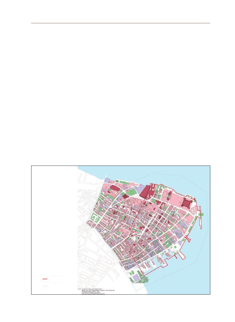
125
Lim Y
ok
e Mui
George Town has been the capital city of Penang since 1786. As a free trade
port, it was once Penang’s leading economic artery. Before Penang became
a part of the first Straits Settlement of the British, it originally belonged to the
Kedah Kingdom. The East India Company took control of Penang when Captain
Francis Light landed on the northeastern part of the island in 1786 and named
it George Town after Britain’s King George III. With burgeoning commercial
activities, the number of traders and workers from different parts of the world,
such as Arabia, Aceh, India, China, Siam, Myanmar, and Europe, increased
rapidly and marked their presence in George Town; subsequently, this increase
in population marked the growth of the town.
The size of the town has expanded naturally since then. The inner city of
George Town is the core area of the United Nations Educational, Scientific
and Cultural Organization (UNESCO) World Heritage Site, owing to its unique
heritage characteristics (criteria (ii) and (iii)) and the well-known historical pre-
war buildings like the two-story shophouses that were built before World War II
(
criterion iv).
Figure 1 shows the core and buffer areas of the George Town World
Heritage Site (GTWHS).
1. Historical
background
of George
Town
Figure 1.
GTWHS Core and Buffer Area (Source: Special Area Plan George Town (2016))
Core Area
Buffer Area

126
The history of these heritage buildings dates back to the late 18th and early
19th centuries. According to a letter from Captain Francis Light dated June
28,1793, brick buildings such as dwelling houses and offices, shops, taverns,
bakehouses, and godowns were already in existence (City Council of George Town,
1966).
More brick buildings were built, especially after major fires in 1789, 1808,
1812, and 1826 (City Council of George Town, 1966; Khoo, 1994) when timber and attap
roof buildings were no longer allowed to be built. By 1887, the timber buildings in
George Town had been fully replaced by brick buildings (City Council of George Town,
1966).
Among the oldest buildings that still survive are Fort Cornwallis (1786, rebuilt
in 1793 and 1810)
and religious buildings such as the Nagore Shrine at Lebuh Chulia
built in the 1800s; Kapitan Keling Mosque and Goddess of Mercy Temple along
Jalan Masjid Kapitan Keling built in the early 1800s; Acheen Street Mosque built
in 1808; St. George Church (1818); Mahamariamman Temple at Lebuh Queen
(
1833)
; and clan houses such as Cheah Kongsi at Lebuh Armenian (~1801). Other
early buildings are the former Government House (1804), which is now part of
the Convent buildings; rows of shophouses (lot 92) on Lebuh Armenian, which
were built in the 1830s and 1840s; Syed Al-Atas Mansion at Lebuh Armenian
in the latter half of the 19th century; and the Town Hall at Jalan Padang Kota
Lama (Esplanade Road) in 1880 (Khoo, 1994). Until 1997, there were approximately
13,000 pre-war buildings in George Town. However, in the Special Area Plan of
George Town, which was gazetted in 2016, there were only 2569 and 2444 units
of heritage buildings in the core and buffer zones respectively, making a total of
5013 units.
1-1 Outstanding Universal Value (OUV) of George Town
The World Heritage Committee (WHC) launched the Global Strategy to
ensure a representative, balanced, and credible World Heritage List (WHL); it
stated that a site must have OUV and fulfil at least 1 of its 10 selection criteria,
to be inscribed on the WHL (UNESCO WHC, 2021). With reference to paragraph
49 of UNESCO’s Operational Guidelines for the Implementation of the World
Heritage Convention, OUV means “cultural and/or natural significance which
is so exceptional as to transcend national boundaries and to be of common
importance for present and future generations of all humanity” (UNESCO, 2019).
By the end of 2004, UNESCO WHSs were chosen based on 6 cultural heritage
and 4 natural heritage criteria.

127
Lim Y
ok
e Mui
The WHL describes Melaka and George Town this way:
Melaka and George Town, Malaysia, are remarkable examples of historic colonial
towns on the Straits of Malacca that demonstrate a succession of historical and
cultural influences arising from their former function as trading ports linking
East and West. These are the most complete surviving historic city centres on
the Straits of Malacca with a multi-cultural living heritage originating from the
trade routes from Great Britain and Europe through the Middle East, the Indian
subcontinent and the Malay Archipelago to China. Both towns bear testimony to a
living multi-cultural heritage and tradition of Asia, where the many religions and
cultures met and coexisted. They reflect the coming together of cultural elements
from the Malay Archipelago, India and China with those of Europe, to create a
unique architecture, culture and townscape. (UNESCO WHL, 2021)
The inscription for the Melaka WHS and GTWHS mention criteria (ii), (iii), and
(
iv)
of the OUV that fall under the cultural heritage category. The full statement of
the OUV for criterion (ii) is as follows:
George Town and Melaka represent exceptional examples of multi-cultural
tradingtowns in East and Southeast Asia, forged from the mercantile and
exchanges of Malay, Chinese,and Indian cultures and three successive European
colonial powers for almost 500 years, each withits imprints on the architecture and
urban form, technology and monumental art. Both townsshowed different stages
of development and the successive changes over a long span of time andare thus
complementary. (UNESCO WHL, 2021)
Figure 2.
Scenes reflecting criterion (ii)
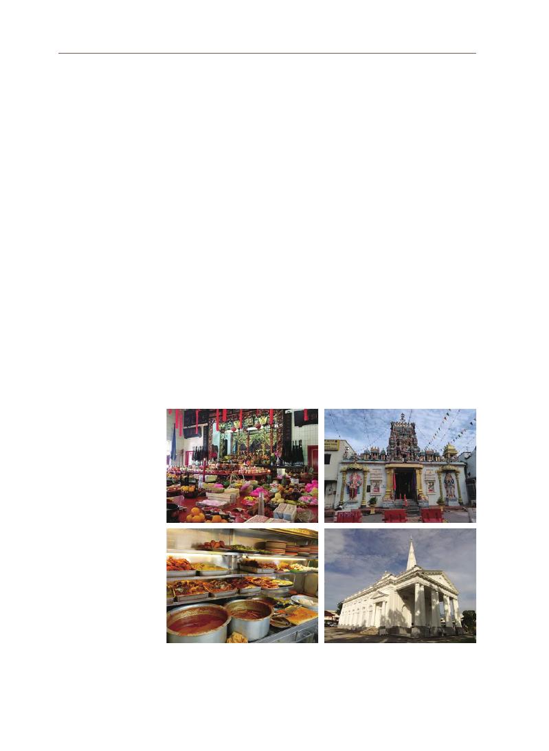
128
The fulfillment of criterion (ii) is due to George Town’s role as a multicultural
trading port city in East and Southeast Asia forged by the commerce and
exchanges of the Malay, Chinese, and Indian cultures, and European colonists.
Although George Town has evolved over the years, the footprints of yesteryear
trading and commerce are still evident. The scenes found in George Town that
reflect criterion (ii) are depicted in Figure 2.
The full statement of the OUV for criterion (iii) is as follows:
Melaka and George Town are living testimony to the multi-cultural heritage and
tradition of Asia, and European colonial influences. This multi-cultural tangible
and intangible heritage is expressed in the great variety of religious buildings
of different faiths, ethnic quarters, the many languages, worship and religious
festivals, dances, costumes, art and music, food, and daily life. (UNESCO WHL,2021)
George Town showcases criterion (iii) of the OUV as a living exemplar of
Asia’s multiplicity of cultural heritage and traditions and colonial powers
displayed through multicultural tangible (ethnic quarters, religious establishments, etc.)
and intangible (dialects, daily life, food, dances, etc.) cultural heritage. The vibrancy of
multicultural traditions is evident in the annual events, religious festivals, and
daily activities. Figure 3 depicts scenes reflecting criterion (iii) in the GTWHS.
Figure 3.
Scenes depicting criterion (iii)
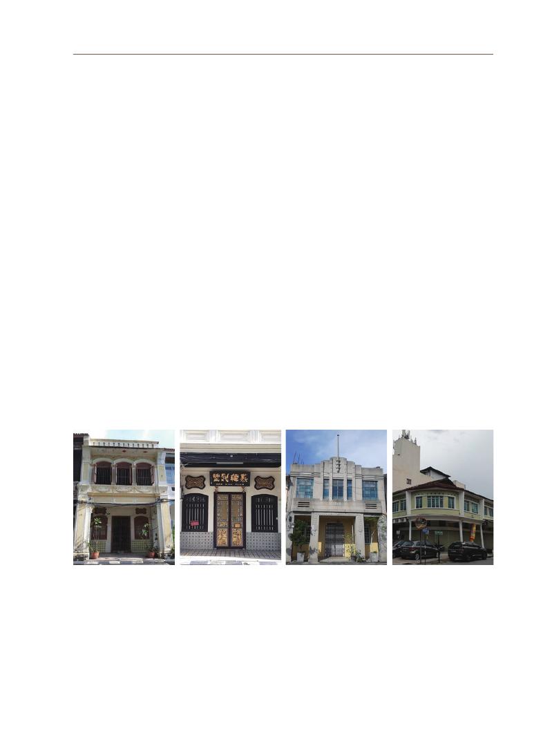
129
Lim Y
ok
e Mui
George Town’s fulfillment of criterion (iv) is displayed through the
shophouses and townhouses found in the city that showcase a mix of influences
that established a unique architecture, urbanscape, and culture that are not
found elsewhere in South and East Asia. The full statement of the OUV for
criterion (iii) is as follows:
Melaka and George Town reflect a mixture of influences which have created a
unique architecture, culture, and townscape without parallel anywhere in East and
South Asia. In particular, they demonstrate an exceptional range of shophouses
and townhouses. These buildings show many different types and stages of
development of the building type, some originating in the Dutch or Portuguese
periods. (UNESCO, WHL,2021)
One of the main attributes of criterion (iv) would be the shophouses of George
Town, exhibiting an exceptional range that was developed over 170 years.
Throughout this period, 6 main styles evolved: Early Penang, Southern Chinese
Eclectic, Early Straits Eclectic, Late Straits Eclectic, Art Deco, and Early Modern
(
Tan 2015).
Figure 4 depicts some of the unique heritage buildings of different
typologies found in the GTWHS. Collectively, the fulfillment of the 3
aforementioned criteria was integral to George Town’s inscription on July 7,
2008, as a UNESCO WHS.
1-2 Post-inscription and Covid-19 threats and resilience in
safeguarding OUV
Globalization and the manner in which urban areas are implicated have
been widely debated in the past. Often viewed as a double-edged sword,
globalization and urban restructuring have their fair share of both advantages
and disadvantages. On the one hand, advocates, who are predominantly pro-
Figure 4. Examples of heritage buildings in the GTHWS

130
growth political leaders, welcome growth-led and market-driven strategies to
stimulate urban development and increase their city’s competitiveness (Brenner
& Theodore, 2013).
On the other hand, anti-globalist critiques cautioned against the
vagaries of globalization, such as unchecked gentrification, marginalization of
vulnerable groups, spiking real estate values/rents, indiscriminate conservation
of historic buildings, displacement of local communities, and infiltration of
modern cultures by gentrifiers as some of the concerns that threaten local
character, place identity, indigenous knowledge, and livelihoods of the locals
(
Smith, 2002).
This scenario becomes more challenging for heritage and historic
cities, where urban spaces get contested between urban conservation and
the appeals of urban modernism. Arguably, a city’s cultural heritage will be
jeopardized and at risk of vanishing if a historic city loses its people, culture,
monuments, and traditional livelihoods.
Like the fate of most cities confronting the forces of globalization, George
Town is also at a crossroads juggling between urban conservation and
modernization with incidences of gentrification, the presence of new businesses
and dwellers (Foo & Krishnapillai, 2018), and cases of social exclusion (Khoo, 2020).
The unregulated transactions of shophouses in the GTWHS by foreign investors
(
e.g, World Class Land)
who bought them en bloc caused rents to increase by more
than 500 per cent (Loh, 2016a, 2016b; Mok, 2016). Many of these properties were
purchased, restored, and converted/adaptively reused as boutique hotels,
museums, or café bistros. Tourism quickly became the cash cow sector,
although critiques have cautioned against the unsustainable nature of the
mass tourism unfolding at the heritage site. This is how economic globalization
and its discontent—has manifested in the GTWHS since the city’s inscription
on the WHL in 2008. To an extent, the status quo challenges the city’s OUV and
the GTWHS’s readiness and resilience to safeguard the city’s authenticity and
integrity. Resilience in heritage can be examined from the perspective of an
ecological resilience framework in which resilience ensures the continuity of
heritage values within the WHS (Seekamp & Jo, 2020). This continuity recognizes the
“
continuous process of evolving tangible and intangible heritage expressions in
response to changing circumstances” (Poulios, 2014).
The GTWHS’s resilience was further tested in 2020 when Malaysia was
exposed to another global shock—the Covid-19 pandemic which is still unfolding
during this study. Since March 2020, the partial lockdowns and Movement
Control Orders (MCO) imposed by the Malaysian government had their fair share
of impacts on the GTWHS and the activities, livelihoods, and fanfare of the people,

131
Lim Y
ok
e Mui
which are attributes of criteria (ii), (iii), and (iv) of George Town’s OUV. Inevitably,
George Town’s socioeconomic and cultural landscapes were impacted and
implicated by the Covid-19 pandemic. The unprecedented Covid-19 pandemic
has exposed and put the resilience, survival, and sustainability of George Town’s
OUV at risk. In a local context, this results in a need to examine and comprehend
the extent to which the 3 selection criteria of GTWHS’s OUV are at risk of being
impacted or resilient to Covid-19. This scenario must be understood against
the backdrop of the aforementioned situation where the GTWHS was already
experiencing a myriad of transformations, issues, and challenges and how
they were exacerbated by the Covid-19 pandemic. Hence, this study focuses
on identifying the extent to which George Town’s cultural heritage is resilient
to Covid-19 coupled with the tensions and challenges of existing changes,
to ensure that the historic city’s authenticity and integrity remain intact for
posterity.
Given that Covid-19 is ongoing globally, limited academic research has been
conducted on its impact on the readiness and resilience of GTWHS’s OUV; only a
handful of preliminary studies have been conducted using local think tanks (e.g.,
Penang Institute, Think City)
to capture quick snapshots of the situation (Lim, 2020;
Think City, 2020).
Hence, this study aims to examine how Covid-19 has impacted
the resilience of the selection criteria (ii), (iii), and (iv) of GTWHS promptly and
fill an important research gap. The findings of this study will lead to better-
informed and evidence-based policymaking as a quest to brace the GTWHS for
unanticipated shocks and increase its resilience in the future.
2-1 Objectives
The objectives of this study are as follows:
1. To establish the survival skills and resilience of the custodians (i.e., urban
dwellers)
in safeguarding the OUV of George Town, Penang, during the
Covid-19 pandemic.
2. To identify the issues and challenges faced by the custodians (i.e., urban
dwellers)
of the OUV of George Town, Penang, during the Covid-19
pandemic.
3. To determine solutions and strategies to shape resilient policies to
safeguard George Town’s OUV, which can serve as examples for other
WHSs during the Covid-19 pandemic.
2. Objectives
and
Methodology

132
2-2 Methodology
To gain insight into the experiences and issues faced by the custodians
of OUV, this study will collect data from the perspectives of the Penang State
residents and business traders in the heritage core zone of GTWHS. By studying
their perspectives, we can capture the pertinent issues and experiences of
the community. In this manner, constructive solutions or alternatives can be
formulated to meet their needs.
The original design catered to respondents who are “custodians” (i.e., business
owners and residents in GTWHS)
of the 3 criteria of George Town’s OUV. The objective
of the survey was to collect data on the perceived survival skills and resilience
of the custodians and to identify factors that can be used to safeguard George
Town’s OUV during the Covid-19 pandemic despite the MCO implemented
by the government. To achieve our objectives, data were collected using a
questionnaire. This method was chosen because it is an established method to
obtain information from the target population about their attitudes, behaviors,
viewpoints, and opinions through a set of standardized questions (Wates, 2002).
Although the original methodology consisted only of a questionnaire survey
(
quantitative),
we had to redesign the methodology since access to business
owners and residents was restricted owing to the multiple MCOs imposed by
the Malaysian government. Due to the amendment to the original methodology,
an additional component—key informant interviews—was added to ensure
richer and more in-depth data. The additional data obtained from the interviews
aided in triangulating the results. However, towards the end of the research
period, the MCO was lifted, and the researchers took this opportunity to collect
the third round of data through a face-to-face questionnaire survey. The data
were checked and organized once the surveys and interviews were completed;
subsequently, the data were analyzed using descriptive statistical methods.
2-2-1 Online Survey
During the Covid-19 pandemic, several lockdowns were imposed by the
Malaysian government since 2020. Due to the lockdowns from May 2021, to
October 2021, the scheduled face-to-face survey for this project could not be
conducted and was replaced with an online survey. The switch to an online survey
ensured no further delay in the data collection phase. The online survey was
prepared using Google Forms. A brief introduction to this project and a link to the
online survey were sent to various stakeholder groups on July 2, 2021. The online
survey was conducted for approximately 1 month and ended on July 30, 2021.

133
Lim Y
ok
e Mui
Two Google Forms were created for the online survey. As Malaysians
conversed mainly in English, Malay, and Chinese, the Google Forms were
created in these 3 languages. One form was created in English and Chinese,
while the other was in the national language (Bahasa Malaysia); this was done
to reach as many respondents as possible. A copy of the survey questionnaire
(
English and Chinese)
is provided in Appendix A of this report. As the Bahasa
Malaysia version is a translation of the English one, it is not included in this
report to avoid duplication.
Creating a Google Form in 3 languages makes it too cumbersome to navigate
and answer, thus, 2 forms with the same questions were created as mentioned
above. Although the online survey lasted for 1 month, the response rate was
rather disappointing, as we only managed to obtain 107 responses (N=107). The
low response rate could be due to the survey fatigue experienced by potential
respondents during this period, where most, if not all, research projects and data
collection are migrated online. In addition, some key informants explained that
most of the targeted respondents/custodians of OUV in GTWHS are not IT savvy
and may not be able to answer via Google Forms. The experience gained from
this research indicates that using technology to conduct surveys may not be
suitable for every study. Suitability relates to the characteristics of the targeted
respondents; in this research, an online survey was not suitable because the
target respondents did not possess sufficient knowledge to use social media/
web-based platforms. Nevertheless, the data are still useful as they reflect the
perceived resilience of the custodians of the OUV in the GTWHS.
2-2-2 Online Interviews and Focus Group Discussion
Considering the limitations of the online survey data, an additional data
collection component was used to triangulate the data. To that end, online
interviews and focus group discussions were conducted after the online survey.
Qualitative data from online interviews and a focus group discussion allowed for
richer and more in-depth findings. Purposive and snowball sampling methods
were used to obtain key informants relevant to this research. Eight interviews
and 1 focus group discussion were conducted. The research endeavors to locate
key informants that represent the multifarious custodians of the GTWHS’s
OUV. To that end, the key informant lists range from residents in GTWHS to the
manager of the WHS. The key informants interviewed are listed in Table 1.
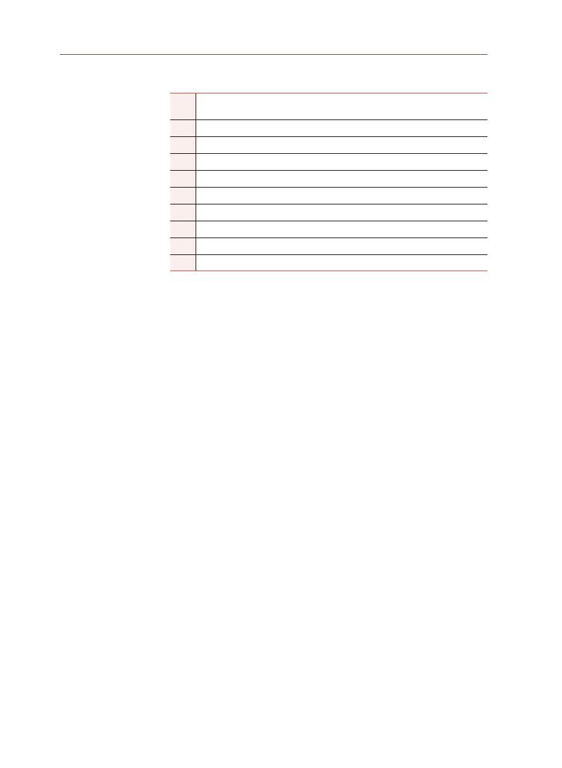
134
Table 1. List of interviewees
1
Executive Secretary of Penang Clan Association and Chair of Penang Cultural
Inheritors Society
2
Architect/Town Planner, business, and property owner in George Town
3
General Manager of George Town World Heritage Incorporated
4
President of Indian Muslim Community Organization Malaysia
5
Money Changer in George Town
6
Property Valuer
7
Resident in George Town
8
Business owner in George Town
9
Special Project Officer of Penang Think-tank*
10
Analyst of Penang Think-tank*
The interviews were conducted online via Webex or Zoom, as the MCO
was still in place. The online interviews were successfully conducted with the
abovementioned key informants from July 20, 2021, to August 11, 2021, with the
exemption of key informant no. 3. Due to her busy schedule, she requested that
she be permitted to provide written answers to the questions. The interviews
were recorded, transcribed, and used for data analysis. Data from the interviews
enabled a deeper understanding of the survey findings.
2-2-3 Face-to-face Survey
Towards the end of the research, the MCO was lifted; this allowed us to
conduct the face-to-face survey. Although we had already conducted an online
survey and interviews, a face-to-face survey was conducted to enhance the
credibility of our data. The face-to-face survey used the same survey tool
(
Google Forms)
and was conducted on October 10, 12 and 13, 2021. Using mobile
devices during data collection, enumerators asked the questions and keyed
the answers into Google Forms on behalf of the respondents. The face-to-face
survey allowed us to select the relevant respondents, such as the traditional
businesses, owners, and tenants in the heritage core area. This enhances the
representativeness of the findings to the heritage core area of George Town.
The selected areas for the face-to-face survey were within the heritage core
zone of George Town, covering the following streets and locations: Queen Street,
King Street, China Street, Masjid Kapitan Keling Street, Market Street, Chulia
Street, Bishop Street, Church Street, Cannon Street, Armenian Street, Carnarvon
(
NOTE: Key informants 9 and 10 are participants for the focus group discussion. They are from the
same organization.)
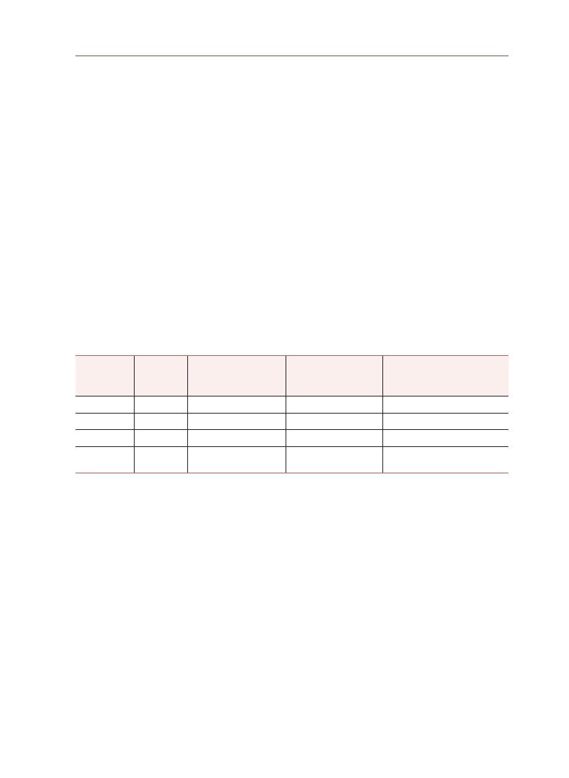
135
Lim Y
ok
e Mui
Street, Lim Chwee Leong Street, and the Padang Kota Lama area. The face-to-
face survey obtained 100 respondents (N=100), making a total of 207 respondents
(
N=207)
for this research.
3-1 Respondents Profile
The following findings were derived from the consolidated data of the
online and face-to-face surveys and triangulated with the data from the online
interviews and focus group discussions. The respondents’ ethnicities are listed in
Table 2. The survey data were compared against the population statistics data of
George Town (GT) in 2010 and the Northeast District (NE) in 2015. The comparison
indicates that the data collected from the survey have similar and comparable
composition of the ethnic groups in George Town. This is important to ensure the
representativeness of the data to George Town’s population.
3. Research
Findings
Table 2. Respondent’s ethnicity compared with the ethnic demography of GT and NE district of Penang
Ethnicity
Frequency
Percentage of ethnic
groups from the
survey (%)
Composition of ethnic
groups in GT (%)*
Composition of ethnic groups
in Northeast District (%)**
Malay
65
31
32
23
Chinese
117
57
53
65
Indian
23
11
9
12
Did not state/
Others
2
1
6
-
(
Note: *2010 statistics, **2015 statistics)
The survey also looked at the employment category of respondents to ensure
that we had a good representation of traditional businesses in our data. Figure
5 shows the percentage of respondents according to employment category. In
this survey, respondents from traditional businesses were the highest (37%),
followed by students (17%), and new heritage-related businesses (15%). New
heritage-related businesses include heritage-themed cafés, souvenir shops,
tour agencies, guides, and tourist attractions. Respondents in the categories of
non-heritage-related comprised businesses (14%), academics (10%), retirees (4%),
government agencies (2%), and art and culture groups (1%).
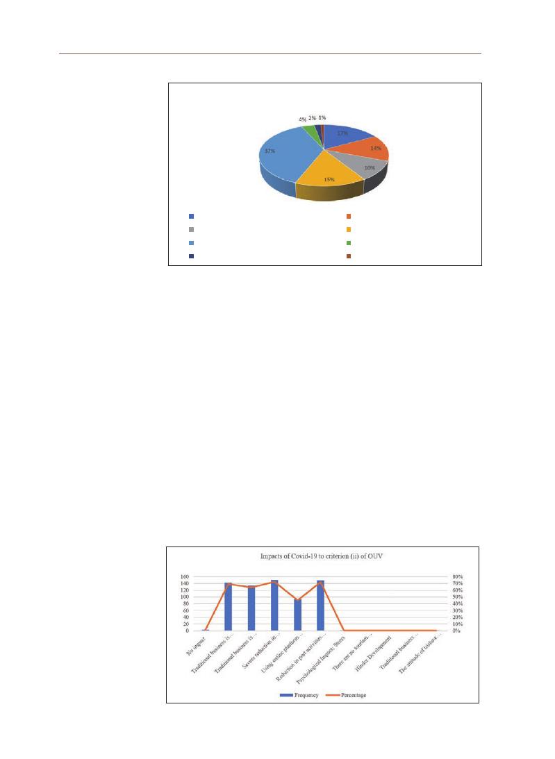
136
3-2 Impact of Covid-19 on the OUV (Criterion (ii))
With reference to Table 3 and Figure 6, respondents were asked about the
impact of Covid-19 on criterion (ii), which is George Town’s role as a historic port
and trading town. The findings show that a large majority of respondents (72%)
indicated that a severe reduction in customers/sales threatened the survival of
traditional businesses. This is followed closely by the impact of the reduction in
port activities and cruise tourists, which will cause some businesses/activities to
eventually disappear. Some of these activities include cruise tour agencies and
petty trishaw businesses. The petty trishaw business is a traditional trade and an
endangered mode of mobility at the GTWHS. Another severe impact is the risk
of traditional businesses closing (69%) due to prolonged MCO. This is followed
by the impact on traditional businesses that suffer losses but survive (64%).
Another anticipated impact, though less severe, is “using online platform during
lockdown is insufficient to sustain traditional businesses” (45%).
Figure 5.
Employment Category of Respondents
Figure 6. Impact of Covid-19 on criterion (ii) of the OUV
Employment Category of Respondents
Students(17%)
Academic(10%)
Traditional Heritage Related Business(37%)
Government Agency(2%)
Non Heritage Related Business(14%)
New Heritage Related Business(15%)
Unemployed/Retirees(4%)
Arts&Culture(1%)
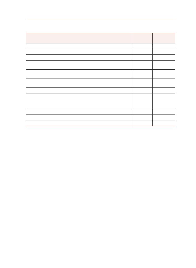
137
Lim Y
ok
e Mui
Interviews with key informants revealed that the impacts on criterion (ii) of
the OUV varied based on business type. The socioeconomic scenario of George
Town has changed drastically since its heyday as a full-fledged port city due
to factors such as the revoking of the free port status and the subsequent shift
of port and logistics activities to Butterworth. Interestingly, an interviewee
perceives that the “wholesale activities” which are often affiliated with George
Town’s port city role, can still be sustained amidst Covid-19 given that such
businesses are not tourism-reliant:
“
Because you look at George Town, whenever we talk about the multicultural
trading and things like that, it’s a lot of wholesale activities. Because most of these
businesses that we are looking at⋯the wholesale side, that’s why this is where I
have two different answers. If you are talking about the wholesale. The wholesale
businesses are not relying on tourism. And if you are talking about wholesale, the
difference is the small traders and small retailers who still go to these wholesale
outlets to go and get their stuffs. So, if you are looking at the wholesale⋯I will think
they will still survive, because their priority is about selling it to the downstream.”
(
Architect Planner, July 20, 2021)
Table 3. Impact of Covid-19 on criterion (ii) of GTWHS’s OUV
In your opinion, which of the following is/are the impact(s) of
Covid-19 to criterion (ii) of George Town?
Frequency
Percentage
No impact
3
1%
Traditional businesses are closing due to prolonged MCO.
143
69%
Traditional businesses are suffering losses but still surviving.
133
64%
Severe reductions in customers/sales threaten the survival of traditional
businesses.
150
72%
Using online platforms during lockdown is insufficient to sustain traditional
businesses.
93
45%
Reduction in port activities and cruise tourists will cause some business/activity to
disappear (e.g., trishaws, cruise tour agencies).
149
72%
Psychological Impacts (e.g., stress)
1
0%
There are no tourism activities due to the MCO. Thus, it significantly impacts
cultural heritage tourism, such as the cancellation of festivals and celebrations
which results in the lack of employment opportunities for practitioners in
performing arts.
1
0%
Hinders development
1
0%
Traditional businesses cannot sustain
1
0%
The attitude of the trishaw driver is bad
1
0%

138
At the same instance, the “port element” is viewed differently by some local
traders by linking the impacts of criterion (ii) to modern and contemporary
maritime activities like the arrival of international cruises and tourists aboard
who stop over. In this regard, businesses that rely on such modern maritime
activities are hugely impacted, as depicted by a local trader:
“
Yeah, I think the impact definitely is very huge. I think in terms for the port, a lot
of international cruises. They come and they are one of the main sources that we
get our customers, especially for the traders around George Town area. For me
myself, I’m actually a trader. I have a shop. From March (2020) onwards, we can
hardly do any business. You see⋯so many months already we can’t open shop.”
(
Batik trader in GTWHS, August 6, 2021)
In addition to wholesale trading and cruise activities, criterion (ii) is linked and
intertwined with other upstream and downstream activities, such as selling food
to urban folks at the heritage site. During the lockdowns and MCOs, retail and
petty businesses were impacted as they could not open and operate.
“
There are different kinds like the selling food one here is OK but the others really
suffer. They all cannot open their business.”
(
All Clans Executive Secretary, July 22, 2021)
3-3 Impact of Covid-19 on the OUV (Criterion (iii))
With reference to Table 4 and Figure 7, respondents were asked about the
impact of Covid-19 on criterion (iii), which is George Town as a living testimony
to the multicultural heritage and tradition of Asia, and European colonial
influences. This multicultural tangible and intangible heritage are expressed in
the religious buildings of different faiths, ethnic quarters, languages, worship
and religious festivals, dances, costumes, art and music, food, and daily life.
The findings indicate that the loss of cultural and heritage tourism has been the
most impacted (58%) Most of our interviewees agreed with this, and one of them
explained it as follows:
“
Those shop near to the Cannon Square and outside Khoo Kongsi, there are many
shops. I think (now) they are actually closed down. They did not even open at all
because I would say that they are 100% dependent on tourists, I mean local people
seldom come down (here to shop).”
(
Resident in GTWHS, August 7, 2021)

139
Lim Y
ok
e Mui
Additionally, annual events and festivals have been curtailed, contributing
to the loss of heritage tourism. Although there have been efforts to migrate
festivities to online platforms, they have not been very successful, as mentioned
by one of the key informants:
“
So, I understand also they are trying that time early of the Chinese New Year, they
are trying to do the online type of festival but online is very different⋯because you
are seeing it through PC (personal computer) then there is no feeling, I think. So, I
think it is very quiet... this year tourism is very quiet.”
(
Property Surveyor, August 11, 2021)
Another finding suggests that the reduction in the businesses of traditional
traders/artisans such as the songkok (a traditional hat worn by the Malays) maker
puts them at risk of extinction (56%). This is an important point for policymakers
to note where the additional threat of Covid-19 has contributed to the traditional
traders/artisans becoming the endangered attribute in the heritage ecosystem
of the GTWHS.
Interestingly, the survey found that although Covid-19 negatively affected
religion-based businesses, such as the supply of prayer paraphernalia and food,
the respondents thought that such businesses would survive (46%). This point is
explained by 2 of the key informants:
“
The thing is interestingly about food, they don’t only cater to the tourists, they are
actually catering to the locals as well. So, I think they will stay on. Yeah.”
(
Architect Planner, July 20, 2021)
“
Effect for the supply of prayer requisites is negative but still will survive. As I said,
it is still difficult but still survives. Like I see near the Kuan Yin Teng (Temple of
Goddess of Mercy), the joss-sticks shops are all open. In front of Carnarvon Street,
there are also 3 shops, I saw they have tried to sell prayer requisites in Shopee and
Lazada (online shopping platform).
(
Money Changer in GTWHS, August 19, 2021)
However, the same percentage of respondents (46%) also think that the
practices of traditional prayer rites and rituals may phase out and gradually
disappear. Data from interviews with key informants also concurs with these
findings:

140
“
But what I’m saying is that younger generation already don’t go to temples now,
10 years down the road the older generation started to ‘taper off’ then you get less
and less young people going and ultimately it will be become a fan base or the
place for tourists, people come in and see.”
(
Architect Planner, July 20, 2021)
“
For example, in gatherings for celebrations or prayers, it is usually done in
a group gathering. Traditionally, the more people the better but with social
distancing, the allowable gathering of 200 people is slowly being reduced to 10 or
15 people only. As this has dragged on for a year, many will not attend anymore.
(
They will think) it is alright, I will just pray from my home or I just attend the prayer
online. That means the foundation of group prayer will gradually disappear.”
(
President, Indian Muslim Community Organization Malaysia, August 14, 2021)
A smaller percentage (36%) thought that Covid-19 restrictions would cause
the prayer requisites businesses to disappear, while 13% thought that there
was no impact at all. One of the key informants explains why he believes that the
prayer requisites business will disappear:
“
Maybe the small stalls, they will disappear. A lot of the sellers are already very old.
I remember near the Kuan Yin Teng, there is a lady selling red colour bread (usually
used for prayers). Now I don’t see her anymore. She seems like just suddenly
disappeared. Since young, I am always in this area so I can see the changes.”
(
Money Changer in GTWHS, August 19, 2021)
From the above data, it seems that larger prayer requisites businesses that
are conducted in shops could be more resilient, as they can adapt and migrate
to online businesses to survive. However, the small stalls could disappear,
especially if the owners are already old. Usually, government would have missed
out giving aids to this group, as they are usually overlooked based on the small
volume of their business. However, it is this type of stall traders that make up the
OUV of George Town, as the way they produce their products and conduct their
business is still in a traditional way. This finding provides direction for the type
of aid the government or heritage agencies should roll out to safeguard these
often-neglected custodian groups.

141
Lim Y
ok
e Mui
Table 4. Impact of Covid-19 on criterion (iii) of GTWHS’s OUV
Following the MCO, several activities such as religious/cultural festivals and
prayer congregation were curtailed. In your opinion, how have these restrictions
impacted criterion (iii) (multi-cultural heritage)?
Frequency Percentage
No impact.
27
13%
Practices of traditional prayer rites and rituals may phase out and gradually disappear.
96
46%
Supply for prayer requisites is negatively affected and may disappear.
75
36%
Supply for prayer requisites is negatively affected but will survive.
96
46%
Reduction in the business of traditional traders/artisans will put their businesses at
risk of extinction.
116
56%
Loss of cultural and heritage tourism.
121
58%
No participation of the younger generation.
1
0%
No comment.
1
0%
Figure 7.
Impact of Covid-19 on criterion (iii) of the OUV
3-4 Impact of Covid-19 on the OUV Criterion (iv)
As shown in Table 5 and Figure 8, respondents were asked about the impact
of Covid-19 on criterion (iv), which comprises George Town’s shophouses and
townhouses that showcase a blend of influences that developed a unique
architecture, urbanscape, and culture that are not found in East and South Asia.
In general, the findings indicate that there is less impact on criterion (iv) than
on criteria (ii) and (iii). This is evident from the lower percentages of responses
received to questions for this criterion (iv). The findings suggest that the majority
(
57%)
indicated that the impacts of Covid-19 has caused the intention to restore
heritage buildings to be put on hold, and the delay in maintaining such buildings
may cause them to deteriorate. The survey also found that 53% thought that
the periodic maintenance of heritage buildings taking a back seat during the
Covid-19 pandemic has caused the conditions of buildings to deteriorate. In

142
general, the respondents agreed that building conditions deteriorated due to
owners’ decision to not spend money on building upkeep during the pandemic
period.
The experts were asked this question during the interview session to seek
further clarification. Data from the interviews with key informants explain this as
follows:
“
I think periodic maintenance will take a back seat⋯that’s true because if the
hotels don’t open and events don’t happen, it is minimal maintenance you know, so
it is really deteriorated. The intention to restore heritage buildings is put on hold
causing building to deteriorate. Definitely.”
(
Architect Planner, July 20, 2021)
“
Especially for those abandoned building, you know. They(authority) have to look for
the owner (to decide) how they have to maintain, or they have to have some kind of
laws to enforce and maintain these old heritage houses. So that our (heritage) core
will be sustainable, I would say. If there is no law mandating maintenance, I think
if the owner can save (on maintenance) then (they will) save, you know. That kind of
mentality.”
(
Batik trader in GTWHS, August 6, 2021)
The survey also found that another key impact (53%) is that the investment/
demand for heritage properties has also reduced. A key informant explained this
situation:
“
So, investment and demand for heritage shop houses have reduced. Yes. It had
reduced. Nobody wants to take the risk now. Actually, there are quite a lot of things
on sale now. You know⋯ people just don’t know how long it is going to be⋯ the
uncertainty is not giving people a lot of confidence to move on. They just want to
wait and see.”
(
Architect Planner, July 20, 2021)
This is followed by the impact of Covid-19 causing funding and sponsorship
for conservation to become low priority (52%). This finding correlates with the
lack of intention to restore heritage building where both of these inactions will
be detrimental to the “health” of the heritage property. Interestingly, despite
the drop in property prices, 53% stated that investment/demand for heritage
shophouses has reduced, while only 13% agreed that investment/demand has
increased. A key informant explains it this way:
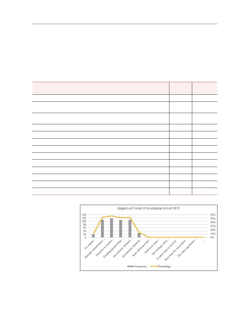
143
Lim Y
ok
e Mui
“
On George Town, now a lot of shop when you pass by you see they close down or
they will put up the ‘for sale’ or ‘for rent’ sign. Things like that, right. So now I think
the market is the buyers’ market. It’s not the sellers’ market⋯ So, for property, I
think it is shrinking also. I think for property, it has shrunk like at least I think 50%
and above. So, I think property (market) is hit very hard.”
(
Batik trader in GTWHS, August 6, 2021)
Table 5. Impact of Covid-19 on criterion (iv) of the OUV
Following the MCO, how have these restrictions impacted criterion (iv)
(
heritage shop houses)?
Frequency
Percentage
No impact.
19
9%
Periodic maintenance of heritage buildings takes a back seat causing buildings to
deteriorate.
110
53%
The intention to restore heritage buildings is put on hold causing buildings to
deteriorate.
118
57%
Funding/sponsorship for conservation is now on low priority.
108
52%
Investment/ demand for heritage shophouses has reduced.
109
53%
Investment/ demand for heritage shophouses has increased.
27
13%
Rent an old house and renovate it.
1
0.5%
Still have some renovations.
1
0.5%
The heritage store cannot be sold as there is a partnership.
1
0.5%
It takes time to recover.
1
0.5%
Best time for renovation.
1
0.5%
The state legislature does not need to be changed.
1
0.5%
No comment.
1
0.5%
Figure 8. Impact of Covid-19 on criterion (iv) of the OUV
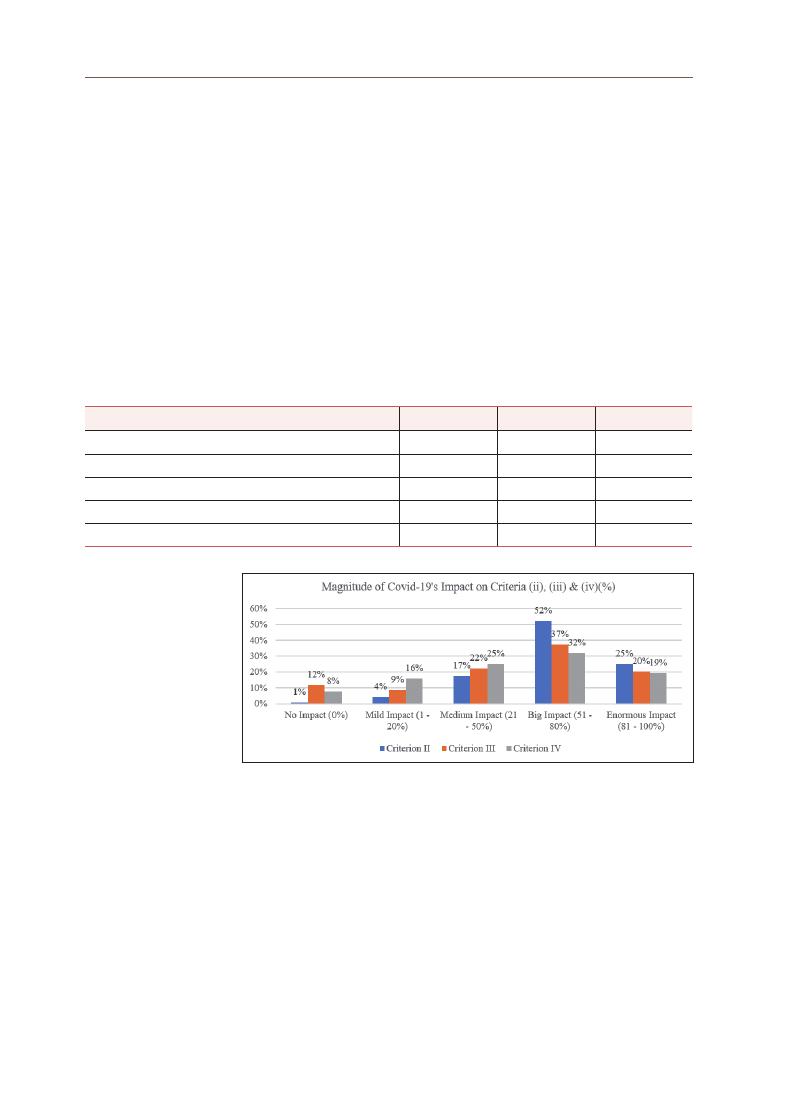
144
3-5 Magnitude of Covid-19’s Impact on Criteria (ii), (iii) and (iv)
During the survey, a 5-point Likert scale was used to gauge the magnitude
of Covid-19’s impacts on criteria (ii), (iii), and (iv) of George Town’s OUV. From
Table 6, it is clear that the magnitude of impacts for the 3 criteria predominantly
fall under the category of “big impact” with criterion (ii) being the highest at 52%,
(
iii)
at 37% and (iv) at 32%.
Based on the findings, it is apparent that criteria (ii) and (iii) seem to be
experiencing a bigger magnitude of Covid-19’s impacts recording “big impact”
and “enormous impact” when compared to criteria (iv). Figure 9 suggests that the
strategies and interventions should be more targeted towards criteria (ii) and (iii).
Table 6. Magnitude of Covid-19 impact on criteria (ii), (iii), and (iv) of the OUV
MAGNITUDE (TOTAL)
CRITERION (ii)
CRITERION (iii) CRITERION (iv)
No Impact (0%)
1%
12%
8%
Mild Impact (1 - 20%)
4%
9%
16%
Medium Impact (21 - 50%)
17%
22%
25%
Big Impact (51 - 80%)
52%
37%
32%
Enormous Impact (81 - 100%)
25%
20%
19%
Figure 9. Percentage of the magnitude of Covid-19’s impact on criteria (ii), (iii) and (iv)
One of the key informants provided insights into the reasons for the impact
being big (51-80%) and not enormous (81-100%).
“
They may not be in the (81 to 100%) enormous impact category because there are
still local people that want to go and ‘bai-bai’ [pray]. They want to worship. They
still need to buy things from the shop. You know, at least they have some customer
base to help them consume the products that they are selling. Last 4 months, I
think the religious part is not so much impacted in the way because tourists even if
they come, not necessary they will go to worship or they will just take pictures.”
(
Batik trader in GTWHS, August 6, 2021)
145
Lim Y
ok
e Mui
3-6 Resilience and Sustainability Criteria for the GTWHS’s OUV
At the end of the survey, respondents were asked to gauge how businesses,
enterprises, or local communities could adapt to the Covid-19 pandemic and
become resilient over time. The survey findings are illustrated in Table 7.
The resilience and sustainability criteria were organized and grouped into 7
categories: a) new business model, b) new digital format, c) digital presence, d)
government intervention, e) business orientation modification, f) cooperation
with different parties, and g) others. The mean reading was tabulated for each of
the 7 categories.
Table 7. Resilience and Sustainability Criteria
RESILIENCE AND SUSTAINABILITY CRITERIA
TOTAL PERCENTAGE MEAN
New Business
Model
Design a new business model taking into consideration social
distancing and health safety measures.
129
62.32%
129
New Digital
Format
Design a new digital format and “go virtual” for businesses.
117
56.52%
105
Design a new digital format and “go virtual”
for cultural tourism.
93
44.93%
Digital
Presence
Enhance digital presence for traditional businesses.
118
57.00%
112
Enhance digital presence for modern businesses.
106
51.21%
Government
Intervention
Need more government intervention(i.e., financial aid, training)
for businesses.
129
62.32%
108
Need more government intervention for communities.
125
60.39%
Adopt new criteria to allocate funds
by the government/private sector.
70
33.82%
Business
Orientation
Modification
Need to reskill and retool.
87
42.03%
70
Diversify business into other areas.
82
39.61%
Downsize business.
41
19.81%
Cooperation
with Different
Parties
Strengthen links with local communities to support small and
local businesses.
109
52.66%
105
Cooperate with other sectors to develop novel services
to help each other.
102
49.28%
Private-Public-Civil Society Partnership to organize initiatives to
support small businesses and local communities.
104
50.24%
Others
Call it a day and close shop.
10
4.83%
3
Forget about the OUV and lose the UNESCO WHS status
12
5.80%
Short video to spread the traditional arts and crafts.
1
0.48%
Need changes in the business
1
0.48%
Intervention according to the type of business, to help them get
out from misery
1
0.48%
Need the assistance from the government very much,
but don’t know who to refer to
1
0.48%
Ever thought of quitting the business
1
0.48%
Teach the children to continue the business
1
0.48%
Skills Assistance from GTWHI
1
0.48%

146
3-6-1 New Business Model
From the findings, the top 3 mean readings were for the new business model
(
mean=129),
digital presence (mean=112), and government intervention (mean=108).
When designing and implementing new business models, social distancing and
health safety measures should be considered. As a majority of the respondents
selected this criterion over the others, it indicates that standard operating
procedures (SOPs) are now accepted as a part of daily activities and businesses
are expected to follow the SOP laid out by the government. Anecdotal evidence
shows that to adhere to the SOP of limiting customers in the shop, some
businesses started accepting orders by telephone and through pickup apps by
customers or organizing delivery for a fee. This reflects their ability to adapt and
change according to the current environment.
3-6-2 Digital Presence
Within the category of “digital presence”, enhancing it for traditional
businesses recorded a frequency of 118, while doing so for modern businesses
had a frequency of 106. While the migration of businesses to digital and
online platforms/formats might be a viable immediate or long-term solution,
the aspects of preparedness and efficiency in IT skills were highlighted, as
illustrated by a local trader and the president of an ethnic group:
“
Yeah. I’ve actually tried a few online. But because I’m new into this, I just do live.
Live on ‘Facebook live’ and all these because I’m new. For online business, you
need to take time to build up your customer base. When you’re online, nobody
knows you and you depend on people to help you share. So actually, a bit tough. I
have a few sessions⋯ I find it a bit hard because I don’t have customer base. But I
think it can be done, but it’s just a bit tough.”
(
Batik trader in GTWHS, August 6, 2021)
“
It is not about the money. Money is a necessity for development but counseling
expertise from consultant⋯ For example, lets’ take the ‘songkok’ (traditional
Malay hat) shop, government/GTWHi can teach the shop owners how to do online
business, prepare a platform for them to do business.”
(
President, Indian Muslim Community Organization Malaysia, August 14, 2021)
An analyst from a local think tank also resonated with similar sentiments
about traders’ readiness and digital literacy in shifting and switching towards a
digital format for their businesses:

147
Lim Y
ok
e Mui
“
So, this is the problem. It is very easy to say we want them to be rescued and
retool and also move online. Some of the people cannot move online.”
(
Analyst from think-tank, July 28, 2021)
Another key informant states that concerns about the stability of connectivity
could deter people from using online transactions.
“
Online I think still not very popular. That’s what I feel, I, myself also sometimes
do not want to pay through online, worry that because of the internet services,
the signal of the area and also the connectivity of the internet⋯ the services are
actually very worrying. I, myself, also experience transaction (done online) but then
it didn’t catch by the system.”
(
Property Surveyor, August 11, 2021)
Although the survey findings suggest the development of a digital presence,
further findings from key informant interviews indicate that it will be challenging.
This is because while it can be easily implemented by big businesses, it is
difficult for small traditional businesses, especially if the owners are old and
without young successors to take over. In summary, the factors mentioned by
the key informants regarding digital presence are as follows:
a) Digital presence is difficult for small businesses to establish because they
do not have an existing digital customer base to tap into. It is difficult to
create a reasonable customer base within a short period, especially when
they do not have the advantage of famous brand names or celebrities to
promote their goods and services.
b) These businesses would need experts to help them migrate to and
manage a digital platform.
c) The existence of these traditional businesses across generations without
technology is one of the reasons for their OUV. Requiring businesses to
suddenly pivot and embrace technology in their processes may not be
possible.
d) The availability of good Internet infrastructure is important to ensure
smooth online operations and instill confidence in people to make online
transactions.

148
3-6-3 Government Intervention
Regarding the government intervention dimension, there are 3 resilience
and sustainability criteria. The need for more government intervention (i.e.,
financial aid, training)
for businesses scored the highest (129), followed by the need
for more government intervention for communities (125), and the adoption of new
criteria to allocate funds by the government/private sector (70).
While the government intervened to assist impacted businesses and traders
in the GTWHS during the pandemic, many informants felt that the government
could have done more. Some extracts from the transcriptions are as follows:
“
You can’t say that the government didn’t help. There is government support,
but insufficient, but then again⋯ at least better than nothing. We need more
government intervention for all, especially financial aid and training.”
(
Money Changer in GTWHS, August 19, 2021)
“
Actually, I hope the government can do something or the authorities could do
something to help these kinds of people or the local.”
(
All Clans Executive Secretary, July 22, 2021)
An interviewee commented on the lackadaisical role of George Town World
Heritage Incorporate, which is the de facto custodian of the heritage site parked
under the purview of the Penang State Government:
“
The first thing that I want to emphasize here is that the body responsible to
oversee the interest of George Town historic city is George Town World Heritage
Incorporated (GTWHI). I feel that in this respect they (GTWHI) have lost their role in
assisting local communities in this area. They could have generated many ideas,
but they have failed in executing their role in ensuring the resilience of GTWHS.
Here I would like to say that I feel GTWHI has failed in helping the community,
especially heritage businesses or heritage communities.”
(
President, Indian Muslim Community Organization Malaysia, August 14, 2021)
“
The confidence in the government I think is not enough. The government needs to
do something to have their confidence back into the market then only people will
start to go out. People will still worry about this. The government needs to be ready
to come out with the plan for the whole year on what are the programs to promote
and enliven the area, mainly tourism.”
(
Property Surveyor, August 11, 2021)

149
Lim Y
ok
e Mui
Besides more government intervention, the interviews also highlighted
the need for private sector involvement in assisting impacted local traders
and communities. Given that many of the historic properties in the GTWHS are
privately owned, an interviewee who is a tenant-cum-trader has called for the
“
big landlords” to cooperate and partner with the government to assist impacted
traders who have difficulties paying their monthly rents. Another interviewee
concurred:
“
I think Penang government can do more. If they cooperate with the landlord. The
big landlords.”
(
Batik trader in GTWHS, August 6, 2021)
“
Maybe like I say the rental whether the private owner willing to help the trader.
So, they can, let’s say let them have six months no rent period for them to catch
up their cash flow then maybe it will help. Everybody helps to make the economy
come back again. It’s not only the government, the private, the landowner must
help to get this going.”
(
Property Surveyor, August 11,2021)
In summary, the factors mentioned by the key informants regarding
government intervention were as follows:
a) The custodians feel that the government should provide more assistance
in the form of financial aid and training to help their businesses and
activities adapt to the new environment brought about by the Covid-19
pandemic.
b) Government interventions to help communities are considered insufficient
and have failed communities that face hardships during the Covid-19
pandemic.
c) The government is considered to be incapable of rallying cooperation
from the private sector, especially the big landlords in the GTWHS, to help
the custodians sustain during the pandemic. These findings also relate
to the criteria for cooperation with different parties (M=105) as a resilience
strategy.
The dimension of business orientation modification recorded the lowest
mean of 70 indicating that the custodians are not willing to downsize their
businesses, diversify into other business areas, or reskill and retool.

150
3-7 Existing Strategies by the GTWHS’s World Heritage Manager
As the site manager of the GTWHS, George Town World Heritage
Incorporated (GTWHI) has implemented some strategies with a funding allocation
of RM1,000,000.00 from the Penang State Government. The program, called
“
George Town in the New Normal”, started on July 8, 2020, until April 15, 2021.
Its objective is to regenerate and assist Penang’s cultural heritage sector, which
has been impacted by Covid-19 to continue to survive in the new constrained
environment. This project comprised 3 components: a) supporting local
business, b) heritage repair, and c) heritage video.
As of November 24, 2021, the GTWHI website mentioned that it has assisted
local businesses in digital marketing promotions to capture new customers
via digital platforms. This strategy supports the survey finding of enhancing
the digital presence of both traditional and modern businesses to ensure the
sustainability and resilience of the OUV. However, only 142 local businesses have
participated thus far, which is only about 4.7% of the 3,000 local businesses in
the GTWHS. While the program has strategized to promote resilience in local
businesses within the GTWHS, the outreach is considered to be very low. Thus,
more robust strategies and solutions are required to safeguard the OUV of the
GTWHS.
The second component of the abovementioned program targets criterion
(
iv)
of the OUV, which refers to heritage buildings. The same website stated that
it will provide a one-off financial reimbursement to a maximum of RM1,500 to
qualified owners or tenants of heritage premises (Categories I and II as gazetted in the
George Town Special Area Plan)
within the GTWHS for minor repair and maintenance
works on their heritage premises. This component of the program aided the
repair of 253 buildings—only 5.0% of the 5013 buildings in the GTWHS (Special
Area Plan George Town, 2016).
Minor repairs include upgrading the electrical wiring,
repainting the interior and exterior walls, removing vegetation from the facade,
and termite treatment. This strategy—to provide grants to fund initiatives and
technical assistance to building owners for restoration and repair works—
is listed in Special Area Plan George Town, 2016 under Strategy D2, Action
D2.1. Although this assistance is in place, the survey findings indicate that the
intention to restore and undertake periodic maintenance is still on hold. This
may cause deterioration of many existing heritage buildings, as the outreach of
this component is very low. Consequently, criterion (iv) of the OUV could still be
under threat.

151
Lim Y
ok
e Mui
The third component of this program is to assist cultural heritage
practitioners to expand their customer base via digital platforms. The program
will help them produce videos and promote them on GTWHI’s website and other
social media channels. To date, 159 videos comprising 59.55% of the cultural
heritage practitioners were produced. This strategy, which uses technology
to help safeguard criterion (iii) of George Town’s OUV, has good outreach as it
managed to cover more than half of the cultural heritage practitioners.
The abovementioned strategies have been quickly implemented by GTHWI to
foster sustainability and resilience in safeguarding the OUV of the GTWHS during
Covid-19. Although the outreach for component 3 is encouraging, the same
cannot be said for components 1 and 2, where the outreach is still very low. This
study suggests further strategies and solutions to complement the existing ones
to reinforce the resilience of the cultural heritage of the GTWHS.
Based on the abovementioned analysis, 4 viable strategies and solutions
were identified and proposed. These strategies and solutions are suggested to
protect and safeguard the attributes of George Town’s OUV.
First, the Covid-19 pandemic has accelerated the need for both consumers
and producers to shift to digital business platforms. In the existing GTWHS
strategies, the site manager (GTWHI) provides a digital platform to promote local
businesses. Taking it further, the assistance should not stop at providing digital
advertising but also ensure proper management of their digital businesses
after launching the platform. The interview findings from this study indicated
that most of the key informants agreed that the government has provided some
help, but many also highlighted that the assistance is insufficient given that most
traditional businesses lack the technological know-how to migrate to online
business platforms and subsequently manage these platforms. In this sense, the
government does not need to be the service provider but should be the facilitator
in setting up “a common digital platform” for all heritage businesses. There
should be a common platform that caters to businesses and cultural heritage
practitioners’ needs in the GTWHS.
Second, training is essential to help these businesses/custodians to manage
and ensure the smooth running of the online aspects of the business. This
will help alleviate the current issues and become a part of capacity building in
sustaining the OUV of the GTWHS in the long term.
4. Strategies and
Solutions

152
Third, for businesses that are very difficult to reskill and retool, the
government could promote a “renaissance of heritage goods” to the local
population. This is common in many parts of the world where the sustainability of
the heritage economy is not solely dependent on foreign/outstation tourists but
also on the domestic market and local population. It is even more critical now to
devise a campaign to attract the younger generation to appreciate and consume
heritage goods. To this end, marketing and branding consultants are required to
advise and help with repackaging, promoting, and marketing heritage goods and
services locally and internationally. For example, curating a hamper of heritage
goods for festive seasons, gifts, and heritage discount vouchers to encourage
sales are viable strategies to boost market demand for heritage goods and
services.
Finally, the use of tax rebates incentivizes short-term solutions; the
government could allow tax rebates on heritage goods to encourage more locals
to purchase them. Special tax rebates may also be given to owners to restore
and maintain their heritage properties to safeguard criterion (iv) of the GTWHS’s
OUV.
The effect of the Covid-19 pandemic is unprecedented, and no communities
have been spared from its devastating effects. The government of Malaysia
has imposed intermittent MCO’s effectively from March 2020 to October 2021
depending on the severity of the Covid-19 cases reported across Malaysian
states and cities. The economy of cities as well as the country in general are
severely affected by the restrictions on economic activities imposed to curb
the spread of Covid-19. However, a heritage site like George Town has an
additional sphere to consider, which is the protection of its OUV. The privilege
of being inscribed as a WHS is entirely due to the city’s OUV, without which
George Town would be like any other modern city. Protection of the GTWHS’s
OUV is particularly challenging due to the main attributes of its OUV are living
heritage. Traditional businesses, heritage practitioners, daily cultural activities,
religious events, and related downstream activities are all curtailed by the MCO.
Over the last 2 years where there has been no demand for “heritage services
and goods” of the GTWHS, what is the impact of Covid-19 on the GTWHS and
its OUV? If living heritage activities are curtailed, will they survive or fade into
non-existence? If heritage buildings are not maintained, will they fall into
disrepair? Against this background, this research is conducted to ascertain
5. Conclusion

153
Lim Y
ok
e Mui
the impact of the Covid-19 pandemic on the OUV of the GTWHS. Additionally,
the attributes that managed to thrive in this challenging climate will provide an
insight into its resilience strategies. This learning of resilience strategies used
by the custodians of OUV in the face of adversity will be synthesized to propose
sustainable and resilient heritage policies to better manage the heritage site of
the GTWHS.
The survey conducted in this research found that all 3 criteria ((ii), (iii), and
(
iv))
of the GTWHS’s OUV have been significantly impacted by the Covid-19
pandemic. These findings indicate that the survival of traditional businesses
is threatened by the severe reduction in customers/sales. The reduction in
certain activities, such as cruise tourism, may also cause the demise of related
businesses, such as the traditional trishaws or cruise tour agencies. The loss
of cultural and heritage tourism is naturally very severe during the pandemic
period. The curtailing of activities during the MCO not only causes empty streets
and shuttered shops in the GTWHS, but more critically, threatens the lively
existence of its living heritage. The key informants voiced concerns about the
disappearance of traditional practices and the closing of related businesses. This
also impacts tangible heritage, such as the heritage shophouses. Shuttering of
shops means that there is no incentive to maintain these heritage properties.
Thus, heritage properties may fall into disrepair due to postponed maintenance
and repair.
Nevertheless, amidst the challenges of this pandemic, there are pockets
of thriving traditional businesses. Some traditional businesses have managed
to adopt technology to create an online presence to generate businesses.
Support from local populations in utilizing heritage services and goods enables
businesses, especially traditional food and sundry shops, to survive without
tourist income. In terms of government help or intervention, the Penang State
Government (through GTWHI) has implemented measures to safeguard criteria (ii),
(
iii),
and (iv) in the program called “George Town in the New Normal.” However,
the custodians of the GTWHS’s OUV found that assistance from the government
was insufficient to build sustainability and resilience.
Learning from the Covid-19 pandemic, the survey indicated 3 key criteria
to build resilience and sustainability: a) creating a new business model, b)
enhancing the digital presence of businesses, and (c) increasing government
intervention. The new business model now entails incorporating standard
operating procedures (SOP) for walk-in customers to prevent the spread of
diseases such as Covid-19 or other unknown viruses in the future. When

154
such SOPs are in place, activities can proceed as usual, which is important in
safeguarding the GTWHS’s OUV, especially criteria (ii) and (iii), which are its living
heritage. The enhancement of digital presence works well for bigger and well-
established traditional businesses where people trust their quality and are
willing to buy from the online shop. However, for traditional smaller businesses,
especially roadside stalls, which have been in existence for many years and
some even generations, migration to online platforms is difficult for them to
implement, and some will just give up and close down the business. Therefore,
the research found that to build resilience for the custodians of GTWHS’s OUV,
the intervention from the government should not only entail financial or digital
marketing assistance but also training in creating and managing digital business
and presence. This need has been reiterated throughout the interviews by the
key informants: training is needed by the custodians of OUV, and the government
should investigate how such specialized training can be mobilized. Thus, resilient
strategies and solutions that are fundamental to building resilience must not be
superficial and only aim at short-term respite. Strategies must have follow-up
intervention in terms of capacity building of custodians to build sustainability and
resilience in the long run.

155
Lim Y
ok
e Mui
Arnold Loh, “Foreigners ‘invading’ pre-war properties in Penang in The Star Online”, 12
June, accessed 14 April 2017 (www.thestar.com.my/news/nation/2016/06/12/
foreigners-invading-prewarproperties-in-penang/, 2016a).
Arnold Loh, “Singapore developer still on buying spree in The Star Online”, 2 September,
accessed 14 April 2017 (www.thestar.com.my/news/nation/2016/09/02/singapore-
developer-still-on-buying-spreegeorge-towns-sociocultural-fabric-at-risk-
says-group/, 2016b).
Brenner, N. and Theodore, N., “Cities and the georgraphies of ‘actually existing
neoliberalism’”, in Lin, J. and Mele, C. (Eds), The Urban Sociology Reader, 2nd ed.,
(
Oxon:Routledge, 2013) pp. 138~156.
City Council of George Town, Penang past and present 1786-1963: A historical account of
the city of George Town since 1786 (Majlis Perbandaran Pulau Pinang, Penang,
1966).
Erin Seekamp & Eugene Jo, “Resilience and transformation of heritage sites to
accommodate for loss and learning in a changing climate”,
Climatic Change, Vol
162
(
2020), 41-55 (https://doi.org/10.1007/s10584-020-02812-4).
“
George Town in the new Normal”, George Town World Heritage Incorporated, accessed
24 November 2021, (https://gtwhi.com.my/george-town-new-normal/).
Special Area Plan George Town, (Penang: State Government of Penang, 2016)
Ioannis Poulios, “Discussing Strategy in Heritage Conservation: Living Heritage
Approach as an Example of Strategic Innovation”,
Journal of Cultural Heritage
Management and Sustainable Development, Vol 4, No.1 (2014), 16-34 (https://doi.
org/10.1108/JCHMSD-10-2012-0048).
Khoo, S. N., “The development of George Town’s historic centre”. In Koenig, A. (Ed.). An
Inventory of heritage buildings and ensembles of George Town, Penang. (Penang:
Building Department & Planning Department, Municipal Council of Penang Island,
1994).
Khoo Suet Leng, “Towards an inclusive creative city: How ready is the Historic City of
George Town, Penang?”, City, Culture and Society, 23, 100367
(
https://doi.org/10.1016/j.ccs.2020.100367, 2020).
Lim Sok Swan, “Covid-19 hits the heart of George Town: a survey of the economic situation
of old trades in the historic city”, (Penang: Penang Institute, 16 June 2020).
Neil Smith, “New globalism, new urbanism: gentrification as global urban strategy”,
Antipode, Vol. 34 No. 3 (2002) pp. 427~450 (https://doi.org/10.1111/1467-8330.00249).
Nick Wates, “How people can shape their cities, towns and villages in any part of the
world”,
The Community Planning Handbook, (London: Earthscan Publications Ltd.,
2002).
Opalyn Mok, “Penang heritage group seeks stop to development at ‘7 streets precinct’ in
The Malay Mail Online”, 1 September, accessed 14 April 2017
(
www.themalaymailonline.com/malaysia/article/penangheritage-group-seeks-
stop-to-development-at-7-streets-precinct).
References

156
Ruth Foo & Gengeswari Krishnapillai, “Preserving the intangible living heritage in the
George Town World Heritage Site, Malaysia”, Journal of Heritage Tourism. (https://
doi.org/10.1080/1743873X.2018.1549054, 2018).
Tan Yeow Wooi, “Penang Shophouses” (George Town: Tan Yeow Wooi Culture and Heritage
Research Studio, 2015).
Think City, “Covid-19 Crisis: Preserving Lives & Livelihoods. A Guide for Malaysian
Policymakers”, slides by Think City, accessed 26 April 2020 (https://thinkcity.
com.my/wp/wp-content/uploads/2020/03/Think-City-Covid-19-Crisis-A-guide-
for-Malaysian-policymakers-2020_03_27-Final.pdf).
UNESCO World Heritage Centre, Global Strategy: Criteria for Selection, accessed 23 Nov
2021, (https://whc.unesco.org/en/criteria/).
UNESCO World Heritage Centre, Operational Guidelines for the Implementation of
the World Heritage Convention, WHC 19/01(10 July 2019) (https://whc.unesco.org/
en/guidelines) (English).
UNESCO, World Heritage List, Melaka and Georger Town, Historic Cities of the Straits of
Malacca, , accessed 23 Nov 2021 (https://whc.unesco.org/en/list/1223/).
This research was funded by the 2021 UNESCO Chair Research Grant Project of the Korea
National University of Cultural Heritage.
Snapshot of the Google Form used in the survey
Acknowledgements
Appendix A
157
Lim Y
ok
e Mui

The Kaveri river is recognized as one of the seven holy rivers in India. The
Kaveri river basin is dotted with numerous sacred settlements that have a
distinctive urban morphology. These settlements gave rise to historic towns
because of their geographically strategic locations along the river. This study
explores the unique relationship between the sacred river of Kaveri and its
sacred settlements from a cause-and-effect perspective. This study examines
the following settlements: Srirangapatnam, renowned for Ranganathaswamy
temple, Tipu Sultan’s Summer Palace, the Srirangapatnam Fort area, Lal Mahal
palace; Somnathpura, renowned for Somnathpura Temple and Hole Narasimha
Temple; Talakadu, renowned for Maraleshwara, Keertinaryaneshwara, and
Vaidhyanatheswara temples; and Sivansamudra, known for the Barchukki
waterfalls. These settlements have distinctive characteristics in the geographic
and cultural contexts of South Karnataka. The study compares and contrasts
the settlements’ urban morphologies, identifies significant commonalities
among them, and determines if they can be attributed to the river. This study,
which is among the very few on this topic, is expected to help trace the causal
relationships between rivers and settlements in southern India. The study also
highlights the need to protect these sites under a regional policy that combines
their identities into a single cohesive cultural landscape. The study’s findings are
expected to contribute to the development of policies designed to protect these
settlements holistically, within a broader cultural and geographical context.
Monalisa Bhardwaj Associate Professor, School of Architecture, Ramaiah Institute of Technology,
Bangalore, Karnataka, India
Sudha Kumari G Associate Professor, School of Architecture, Ramaiah Institute of Technology,
Bangalore, Karnataka
Trace Relationship between Revered River and
Sacred Settlements Morphology in South India:
Case of Kaveri River in Context of South Karnataka
Abstract
Survey Research Papers on UNESCO Chair Research Grant
05

159
Monalisa Bhar
dwaj
India’s geospatial history and civilizations have been inseparable from its
river systems. The older cultures in the country have regarded rivers as sacred
and built numerous traditions spanning from birth to death that conclude at
the banks of rivers. Among the seven holy rivers of India, the Kaveri river is
the southernmost. It originates on Brahmagiri Hill of the Western Ghats in
Karnataka, a southwestern state, and flows in a southeasterly direction for
765 km through the states of Karnataka and Tamil Nadu, and then descends
the Eastern Ghats in a series of great falls. The river divides into numerous
distributaries before falling into the Bay of Bengal. The resulting delta is known
as the “garden of southern India.” (Vetrimurugan et al., 2014).
The Kaveri river basin is dotted with numerous sacred settlements, each
with a distinctive plan morphology. There is a need to vitalize the cultural context
within the historic settlements of Kaveri river, for holistic and sustainable
protection of historic sites in these settlements. These historic towns emerged
because of their geographically strategic locations along the river. This study
examines the relationship between the revered river Kaveri and its prominent
settlements in order to investigate the causal relationships between river
course, geography, and settlement morphology.
Examining this relationship can help us understand how strategic
settlements and their pilgrim festivals have aided in culture reinforcement. The
grandeur of temples was a means of expressing the supremacy of dynasties and
binding their histories with mythologies. Rituals and festivals were a means of
mobilizing people around certain lunar dates in specific seasons and building
routes around the river to foster trade and material exchange. The traditional
approach to conserving the built heritage of sacred places usually focuses on
rebuilding and protecting their monuments and sites.
1-1 Aim
This study investigates the unique relationships between river course,
geography, and settlement morphology along the Kaveri river at the
regional level in order to help revitalize the cultural context of the area’s
sacred settlements which foster investments in the protection of its historic
monuments. This study examines the following settlements: Srirangapatnam,
renowned for the Ranganathaswamy temple, Tipu Sultan’s Summer Palace, the
Srirangapatnam light and sound show, and Lal Mahal palace; Somnathpura,
renowned for Somnathpura Temple and Hole Narasimha Temple; Talakadu
renowned for Maraleshwara, Keertinaryaneshwara, and Vaidhyanatheswara
temples; and Sivansamudra, known for the Barchukki waterfalls.
1. Introduction

160
1-2 Objectives
This study has the following objectives:
•
To study the distinctive character of the settlements listed above in the
geographical and cultural contexts of south Karnataka.
•
To compare between the settlements’ morphologies.
•
To contrast between the settlements’ morphologies.
•
To identify significant commonalities among the settlements and determine if
they can be attributed to the river.
•
To determine if the commonalities have a causal relationship with the geo-
spatial features of the Kaveri river.
•
To recommend strategies for reinforcing the identified cultural commonalities to
protect the historic monuments and sites along the Kaveri as part of a broader
cultural whole.
The Kaveri basin extends over an area of approximately 81,155 square km at
an inclination from northwest to southeast. The basin is located between 1007N
and 13°0’28”N and 75°0’28”E and 79°0’52”E (Clare and Oriole, 2009). The catchment
of the river watershed lies in the states of Karnataka, Tamil Nadu, Kerala, and
Union Territory of Pondicherry. The Kaveri Basin forms a part of the South Indian
Shield, which preserves an early formed crust ( > 2500 Ma). Metamorphic and
igneous rocks predominate throughout the basin, which mark major events of
volcanism, plutonism, metamorphism, and sedimentation (Clare and Oriole, 2009)
The principal soil types are red soil in the Karnataka region and black soil
in Tamil Nadu. Several rivers and streams originate in the Sahyadri Hills and
confluence with Kaveri-Bhavani, Kapila, Lakshmana Tirtha, Hemavati, Ekadi,
Harringi, and Kabini. Traditionally, the sites of the confluence and divergence of
holy rivers are regarded as sacred in India, particularly among Hindus (Ivermee,
2021)
2-1 Climate of Kaveri River Basin
The climate of the Kaveri River Basin is dry except for the monsoon months.
The mean daily maximum and minimum temperatures vary widely across
the region. The mean daily maximum temperature ranges from 19.5° to 33.7°
C, whereas the mean daily minimum varies from 9.1° to 25.2°C. Temperatures
in the western areas, which are at high elevations, are warmest in March (28.5°
C).
Wind in the area is linked with the monsoons and thus mainly blows from
the southwest and northwest during the southwest monsoons. Clouds are also
2. Geology and
Geographical
Characteristics
of Region
around River
Kaveri

161
Monalisa Bhar
dwaj
associated with monsoon activity, with the skies being generally overcast during
monsoons (Clare and Oriole, 2009).
2-2 Precipitation and Humidity
The western side of the catchment experiences the southwest monsoon
from June to September, and the northeast monsoon from October to December
falls on the eastern side. Rainfall during the rest of the period is insignificant.
About 50% falls during the southwest monsoon, about 33 % falls in the northeast
monsoon, roughly 10% fal s in the pre-monsoon periods, and the rest falls in the
winter months. There are more than 100 rainy days per year in the western part
of the basin and 40 to 50 elsewhere in the region (Clare and Oriole, 2009).
This river Kaveri is regarded by many as the
Dakshin Ganga, the “Ganges
of the South,” and is revered in ancient Tamil literature. At the place of its
origin, Talakaveri in Kodagu district, the river Kaveri is celebrated in the Kaveri
Sankarmana festival because it is said to have sprung from the fountainhead
in Talakaveri Temple. The Brahma Kundike (pot), the fountainhead of a pond
located at the springing point of the river, is also celebrated as Theerthodbhava
(
the divinity of the appearance of this river)
through ambulations, holy dips, and prayers.
At the first drop of the river is Bhagamandala, the site of the First Sangam,
near the Kanaka River and the mythical river Sujyothi. Bhagandeshwara, a
Karavali-style Shiva temple, is considered sacred. There are shrines dedicated
to Ishvara, Subramany, and Ganapati. Pilgrims travel long distances, a cultural
practice since ancient times, to take a holy dip in the
triveni sangama and offer
3. Cultural
Significance
of River
Kaveri
Figure 1. Geographic location of
river Kaveri in South
Indian Peninsula
(
source: author)
Figure 2. 2 Image of Kaveri in South Indian Peninsula
(
source: author)
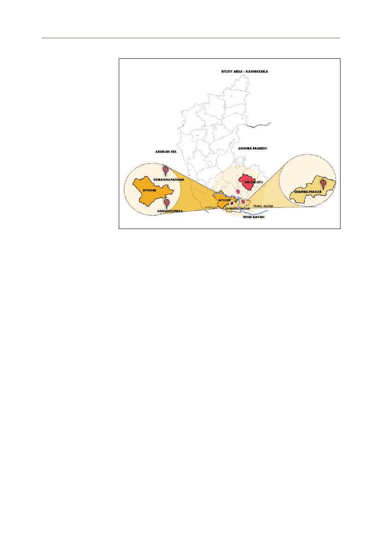
162
ambulations to their ancestors according to prescribed rituals. It has been a
pilgrimage site since ancient times.
Somnathpur is a small and secluded Brahmin settlement on the banks of
the Kaveri. This settlement has many pilgrim sites, including the Chennakeshava
Temple, Talakad Panchalinga Temple, and Mudukuthore Mallikarjuna Temple.
The Archaeological Survey of India declared it a heritage site.
The river, which diverges in south Karnataka, forms two distinctive sacred
islands: Srirangapatnam and Sivasamudram. Srirangapattana has always been
an important religious site; it is the place where it is believed the goddess Kaveri
asked Ranganatha to come and stay. There are many ghats leading down to
Kaveri (Clare and Oriole 2009).
At the sharp bend in the river lies Talakad, a settlement known for its sand
dunes. These unique geographical features have mythological significance.
The area is home to two pilgrimage sites, Vaidyeshvara Temple, where the
Panchalinga festival is celebrated, and the mystical Kirtinarayana Temple, which
is buried in sand.
The Kaveri river is revered as a gift from the gods. The river is believed to
have a divine origin. Numerous oral folk traditions tell of how the cultures along
the Kaveri have believed that the river has bestowed prosperity and salvation
to countless people over the ages (Seshadri and Sundararaghavan, 2012, pp. 15). It is
Figure 3.
Geographical location of sacred settlements along river Kaveri

163
Monalisa Bhar
dwaj
believed that, as mentioned in Agni Puran, written between 300 and 1000 CE,
Lord Vishnu blessed Kaveri, the daughter of King Kavera of Vidharbha, with the
power to destroy the sins of men, after which the river flowed southward from
the Sahyadri Hills.
The Puranas, the classical texts of Hinduism, have myriad narratives that
complement each other in portraying the genesis of cultural landscapes. The
significance of India’s holy places (e.g., tirthas, holy rivers, and other sacred sites) is
based on the sanctity of the cyclical pattern of death and rebirth as the ultimate
truth of human life, the existence of divinity, and the possibility of breaking the
chakra of the cycles of death and rebirth (moksha). The settlements and cultures
along the Kaveri have long been sites of great sacred and temporal significance.
Cultural landscapes are historically significant places that show evidence of
human interaction with the physical environment. Their authenticity is measured
in terms of historical integrity, defined as the presence and condition of physical
characteristics remaining from the historical period (Birnbaum, 1994). The Kaveri
river is central to the cultural landscape of south Karnataka due to its continuing
cultural legacy.
The river course has given rise to settlements through divine attributions
given to distinctive food cultures, festivals, garment styles, music, dance forms,
and literature. This study seeks to develop an understanding of the historical
context before undertaking the site study and analysis of selected historic
towns. The site study is a ground-truth project aimed at developing satellite
image-based spatial plans for the study areas. These spatial plans are then
used to develop urban morphology drawings. The drawings are then analyzed to
understand, compare, and contrast the features of the settlements that have a
common cultural past.
4. Methodology
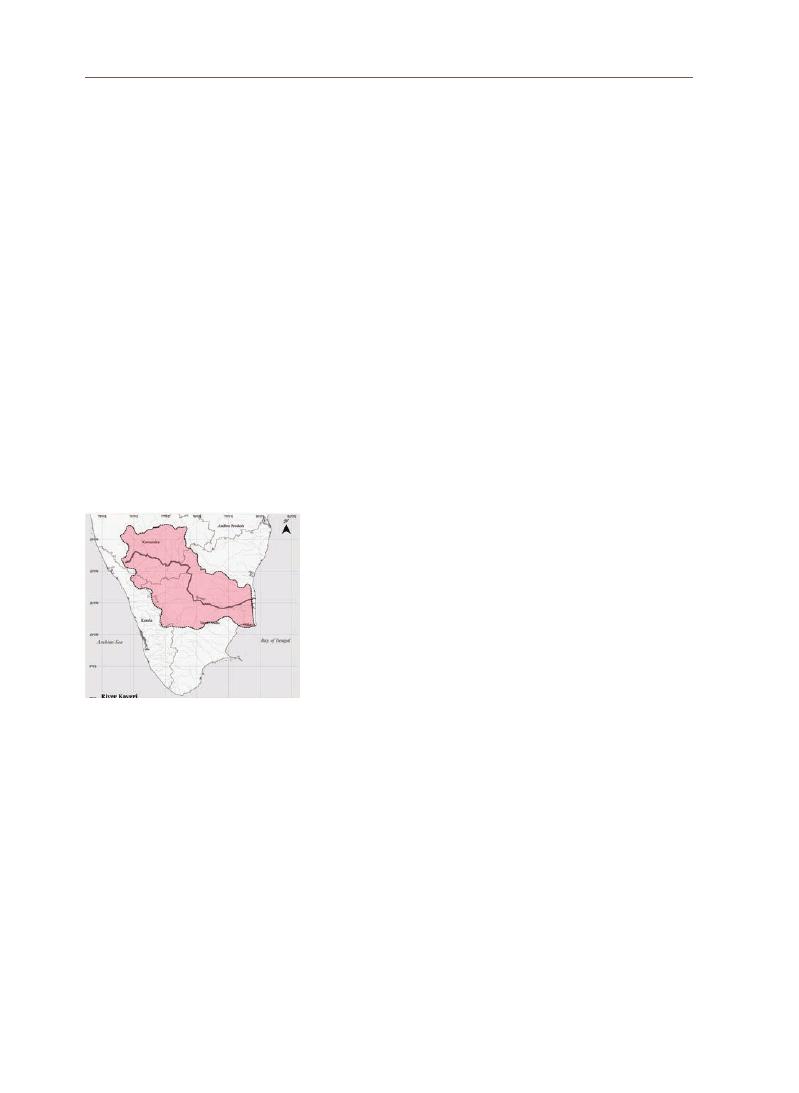
164
5-1 Historical Context
The archeological site of Payampalli contains evidence of Stone Age
habitations dating between 1500 and 300 BC (Seshadri and Sundararaghavan, 2012,
p. 4).
This region was inhabited by Neolithic cultures who practiced some type
of agriculture. Evidence dating from between 1000 and 300 BC has also been
discovered (Seshadri and Sundararaghavan, 2012, p. 5). Vedic and Brahmanic culture
and beliefs are believed to have arrived in South India before Buddhism and
Jainism, based on knowledge of Itihaas-puran, a tradition related to Rishi
Agastya—who is, incidentally, central to the origin of the Kaveri River (Karashima
2014, p. 67).
Kaveri Ashtakam is a stotram, recited in prayer for the Kaveri river,
which is regarded as a divine blessing, personified as the beautiful young
daughter of King Kavera. The verses of this hymn worship the auspicious, pure,
benevolent Kaveri who is worshipped by gods and men alike. A verse from the
hymn, as below, highlights how the river Kaveri was central to the belief system
of south Indian cultures- across the section of hindu society:
Devaalaya pooritha divyatriire
Samasta lokottama tiirtha muurdhe
Kashmiirabhooh kalpita choladeshe
Kaaveri mama prasiida
(
from “Kaaveri Ashtakam”; the verses translate as “Your auspicious
banks are crowded with the abodes of gods. Throughout the world, your
holy places are the best. The beauty of Kashmir seems to pervade Chola
because of you. O Kaveri! Shower your blessings on me” [Seshadri and
Sundararaghavan, 2012. p. 184])
5-2 Study Area: Evaluating Integrity and Significance
An inscription in the cave dug by the Pallava king Mahendravarman 13
centuries ago reads as follows:
Kaveri captivates the eye. She bears cool waters, and the meadows on her banks
are like garlands on her neck. The great Lord Shiva himself has come down
here to look at the beautiful Kaveri. Although he bears the Ganga on his head,
Goddess Parvati (his wife) fears he might now want the Kaveri too! To avoid such
entanglement, it is as if Parvati is sitting here beside Shiva and reminding him that
Kaveri rightfully belongs to the Pallava Kings. (Seshadri and Sundararaghavan,
2012, p. 168)
5. An Approach to
Understanding
the Cultural
Landscape of
River Kaveri
Figure 4.
Kaveri River Basin area in
southern India (source: author)
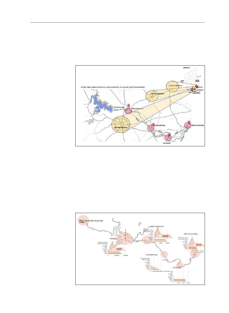
165
Monalisa Bhar
dwaj
The significance of Kaveri is deeply entwined with the mythology and
historical accounts in which gods, kings, and people all revere the sacred
river Kaveri. This belief system is common within the cultural boundary of the
southern Karnataka and Kaveri Delta in Tamil Nadu.
The selected study areas showcase this homogeneity in religion, practices,
and physical manifestation in their temple complexes of historic significance.
Demographic and religious data for the selected region reveal that most area
residents practice the Hindu religion rooted in the Vedic-Brahminical system.
This is a major factor in the cultural integrity of the study areas.
Figure 5. Spatial setting of identified settlements (Srirangapatna, Somnathpur,
Talakadu, Shivanasamudra), with reference to river (source: author)
Figure 6. Demographic and religious profiles of identified settlements, showing that
most residents follow the Vedic-Brahminical religion

166
The Kannada, Tamil, and Telugu languages are commonly spoken and
understood in the study areas. These are pivotal in preserving the oral histories
and belief systems that date back to the 4th century CE. Following the lunar
calendar used in Hindu astrology, the various cultures have been integrated
through festivals, harvest rituals, and pilgrimage seasons. The Srimad Bhagwat
Gita says that those who drink the holy water of River Kaveri will become
followers of Lord Krishna (Kannan, 2019, p. 4). The Kaveri river is integral to the
2,000-year-old tradition of Tamil literature, such as in Vuruthinkannanar,
Seethalai Sathanar, Porunaratuppadai, Silappathikaram, Seethalaichathanar,
Kamban, Sekkizhar, Thirungnana Sambandar, and Sree Villiputheurar, among
many others.
5-3 Landscape Interpretation at the Regional and Settlement Scale
5-3-1 Temple complexes along River Kaveri as historic designed
landscapes
Kannan claims that “It is believed that during the month of Thula (Ippasi)
everyday one-half hours before sunrise the mighty three Shiva, Vishnu, &
Brahma, nine hundred million gods and sixty eight thousand sages bathe in
Kaveri” (2019, p. 3). This mythological relationship between river sacredness,
Hindu gods, and sacred lunar months dates back about 2000 years. The
numerous temples that were built along the Kaveri river manifest this cultural
belief system and constitute the common origin of numerous historic sacred
settlements that serve as famous pilgrimage sites. Important temples and
pilgrimage sites along Kaveri include the following:
In Karnataka:
Thalai Kaveri, the origin of the river in Kodagu.
Athiarangam, an island (Srirangapattnam) encircled by the Bassima river and
Poorra river; a holy site, Basmirangam, is at their confluence.
Anantha sayan, near waterfalls on the island of Shivasamudram; also the site of a
statue of mother Kaveri.
Chamundeshwari Temple in Mysore.
Nanjankodu Srikandeshwaarer Temple south of Mysore.
Somanathpuram Kesava Temple, a temple so beautiful that the devas/gods
wanted to take it to the heavens.
Panchalinga at Talakadu-Arkeshwara, Vaidyeswara Temple (a temple renowned
for its healing powers), Pathaleshwara, Murudeswara, and Mudukuthore.

167
Monalisa Bhar
dwaj
In Tamil Nadu
Thirunana (Barani) at the confluence of the Barani and Kaveri rivers.
Kodimada Sengunthur, a temple of Arthanareshwar.
Venjamkoodal, at the confluence of the Amravathi and Chitraru rivers.
Pashupathinathan Temple in Karuvur
Karumbarkuzhali and Rathinagiriswar temples in Kadambanthurai.
Tharungaraneshwar Temple, Thirupparayathurai, at the divergence of Vada Kaveri
and Kaveri.
Anjalakshi Temple at Karkudi.
Panjavarneswarer Temple at Mukthiswaram.
Bhoologa Vaikundam, situated on an island.
Mudhuvaneshwari Temple, situated on hilly terrain.
Thirupoonthuruthi Temple complex, situated between Kaveri and Kudamurutti.
Thirukandiyur, a mythologically significant place where Shiva beheaded Brahma.
Tanjore, a temple built by the Chola kings; it is an Archeological Survey of India [ASI]
monument.
Thenkudi, an island formed between Vennaru and Vettaru, both sub rivers of Kaveri.
The temples listed above were all patronized by kings and were hotspots of
cultural development. Forms of dance, literature, and music such as Carnatic
music were developed in these institutions. The settlements that developed
around these temples and temple complexes still exist today, and many—such
as Srirangapattnam, Shivasamudran, Talakadu, and Tanjore—are recognized for
their historic significance.
5-3-2 Talakadu as Historic Site
Talakadu is a historic site recognized and protected by the Archeological
Survey of India. It is unique and is known for its sand dunes, which have gradual y
been deposited on the inner bend of River Kaveri. This geographical event forced
migration outwards. The site is regarded as cursed based on oral history. In the
7th century, queen Rangamma traveled to meet her husband in Talakadu, where
he was battling with the king of Mysore. She arrived to find that her husband
had been killed and threw herself into the Kaveri while laying several curses:
that Talakadu would be buried in sand, that the river in which she jumped would
become a whirlpool, and that the Mysore dynasty would end for lack of an heir
(
Seshadri and Sundararaghavan, 2012).
Talakadu had an important presence in the
rich agricultural region of Kaveri and was a significant trade route between
Karnataka and the plains of Tamil Nadu. It has a unique place in the historic
settlements of Kaveri.
168
5-3-3 River Kaveri as an Ethnographic Landscape
The roots and belief systems of many people, particularly the Kodavas, are
deeply entwined with the story of River Kaveri. Many communities trace their
origins to mythological narratives involving the Kaveri’s history. The river is the
source of water and therefore food to the region. The river is thus pivotal to the
agricultural and animal husbandry practices of the region. The Karnataka region
has been primarily inhabited by agrarian cultures. The region’s numerous river
islands, sacred sites, unique food resources, and cultural resources such as
Carnatic music all contribute to the ethnographic landscape character of River
Kaveri.
At Talakaveri, in the southwest corner of Karnataka, the Kaveri, the Ganges
of the South, is born high up in the green Brahmagiri Mountain at an elevation of
1,340 m above sea level (Clare and Oriole, 2009). Between October and November,
depending on the calculation of local astrologers, the Kaveri bubbles up in
rebirth. At this time, the Kodagu region welcomes thousands of devotees who
are undertaking a pilgrimage to the holy bath in the tank built near the origin
of the holy river Kaveri. Srirangapattana is another important religious site on
the sacred island and is the place where the goddess Kaveri requested Lord
Ranganatha to manifest. The area features the Sri Ranganatha Temple, and
ghats leading down into the Kaveri can be found everywhere.
The word
pushkaran means “worship of the sacred river.” There are 12
rivers where the Maha Pushkaram or Pushkaralu are celebrated, with each
river getting its turn every 12 years. Several
homams and yajnas are conducted
Figure 7. Cultural practices of communities worshiping the Kaveri river
(
image source: Internet)

169
Monalisa Bhar
dwaj
throughout the 12-day period of Maha Pushkaram. Kaveri Pushkaralu and
Cauveri Maha Pushkaram are large festivals for farmers and devotees in South
India (Merala, 2017). Maha Pushkaram is a 12-day festival that celebrates the
river Kaveri, with thousands of devotees gathering to pay their respects and
offer prayers to the river. Most of these devotees depend on agriculture for a
living and therefore pray for good rains and crops during the Kaveri Pushkaralu
festival (Merala, 2017).
Srirangam hosts around 20,000 festival devotees, who arrive from the
neighboring states of Andhra Pradesh and Telangana. Mayiladuthurai is another
popular pilgrimage site for the Kaveri Pushkaralu celebration and sacred
holy dips, which are a major part of prayer rituals. Apart from these popular
sites, locals and devotees also visit several Tamil ghats along the Kaveri river
to celebrate the Kaveri Maha Pushkaram. These periodic festivals reinforce
cultural continuity and serve as a setting for integration, along with deeply
sacred pilgrimages.
Van Oers has observed that the concept of “historic urban landscape,” as
adopted and promoted in recent years through UNESCO and supported by the
International Council on Monuments and Sites (ICOMOS), is an attempt to articulate
an overarching tool for the holistic management of historic cities, from the
protection of their visual image through to the conservation of their historic built
environment and its enhancement via appropriate contemporary intervention,
enabling the continuity of the socio-cultural human activities that constitute an
indispensable component of its sense (or spirit) of place (Oliveira, 2016).
In the United Kingdom, conservation approaches consider settings larger
than individual sites from two principal perspectives: One considers the site’s
architectural and historic interest and streetscape (or townscape, arguably a
misnomer)
; in the other, the protective system is fragmented and only identifies
individual listed buildings and conservation areas. No policies or guidance
is provided for historic cities as a whole, and there is no perception that any
are needed (Rodwell, 2007b, 2008b). These works are referred to bring out the
perspective that conservation of historic sites is an incomplete effort. The site,
its setting, its vitality and relevance all are integral to any approach that aims to
conserve the heritage in a holistic manner.
The settlements along River Kaveri need to be understood as part of a
broader cultural heritage, the urban morphology of which can reveal a deeper
6. Settlement
Morphology
Characteristics
in Region
around River
Kaveri

170
understanding of a common past and collective legacy. The following four
settlements were studied to determine their morphology and spatial plans
and to compare and contrast their characteristics from historical and cultural
perspectives.
6-1 Srirangapatna
6-1-1 Settlement Morphology Study
Srirangapatna is 18 km away from Mysore district, an island city
surrounded by the Kaveri river. The historical site dates back to the 9th-century
Rangnathswamy Temple, which is worshipped by Vaishnavas, participants in a
Hindu pilgrimage that begins at Adi Ranga at Srirangapatna or Madhya Ranga
at Shivanasamudra and ends at Antya Ranga at Srirangam (Tamil Nadu State),
running along the river Kaveri.
The fort built around the city by Hyder Ali and Tippu Sultan in the 17th
century, remains of the fort wall, the Tippu Sultan summer palace, Lal Mahal
Palace, and Tipu’s death site (the British killed Tippu in the Battle of Srirangapatna) can
all be seen. This place has religious and historical significance for both Hindus
and Muslims.
Figure 8. Landmark and land use map, Srirangapatna (source: author)

171
Monalisa Bhar
dwaj
Figure 9. Kaveri river activity, Srirangapatna (source: author)
Figure 10.
Hierarchy of road network, Srirangapatna (source: author)
Figure 11.
Settlement pattern, Srirangapatna (source: author)

172
6-2 Somnathpur
Somnathpur is an important historic settlement known for its beautiful
Hoysala temples. The great sculptor Jakkanachari is credited with these
masterpieces (Jankiraman, 2002). Somnathpur is situated in south Karnataka,
and is about 35 km away from Mysore city. Chennakeshava Temple is the most
famous of the area’s historic temple nad is known to have been built by the
Hoysala commander Somnath in 1268 AD. The temple was built in soapstone.
The Archaeological Survey of India has recognized it as a Heritage Site.
6-2-1 Settlement Morphology Study:
Figure 12.
Figure ground map, Srirangapatna (source: author)
Figure 13.
Chena Keshava Temple and road network, Somnathpura (source: author)
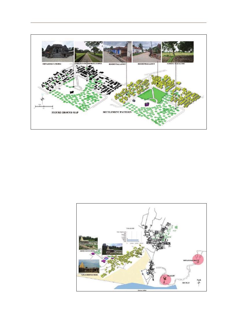
173
Monalisa Bhar
dwaj
6-3 Talakadu
Talakadu is situated approximately 45 km away from Mysore City and
185 km from Bangalore in southern Karnataka. Talakadu is a historic site of
archaeological importance. It is known as a spiritual pilgrimage center and
boasts unique scenic beauty owing to its riverine sandy banks. It is an ancient
town and home to monuments protected under the ASI, such as Kirti Narayan
Temple.
Figure 14.
Ground and settlement pattern, Somnathpura (source: author)
Figure 15.
Settlement morphology and spatial setting, Talakadu (source: author)
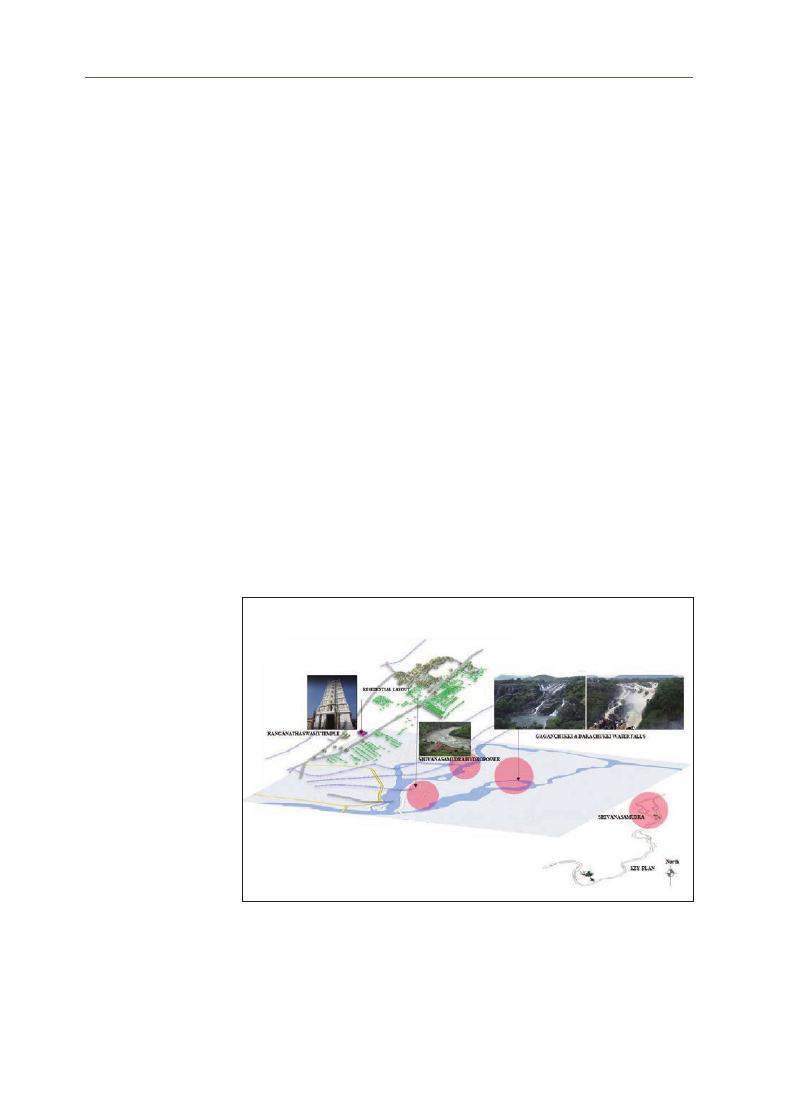
174
Due to the historical account of the “triple curse” on Talakad, nearly 30
temples are believed to be submerged in sand, which is said to have forced
people to migrate away (Jankiraman, 2002) The Talakad Panchalinga Temple is
a popular place for pilgrims. Dedicated to Lord Shiva, this temple is known for
the Pathaleshwara Shivalinga, which is red during the morning, black at noon,
and white in the evening. The Mudukuthore Mallikarjuna Temple is another
important site.
6-4 Shivasamudram
Shivasamudra, an island settlement, is situated where the river Kaveri
descends sharply to 75 meters, in two beautiful waterfalls into rocky gorges,
in the Mandya district of South Karnataka. Shivasamudram is the second
largest waterfall in India. It has twin falls, Gaganachukki and Bharachukki,
within a distance of 1 km. Kaveri splashes into majestic falls, one of which is
Shivasamudram. Asia’s first hydroelectric project was established in 1905. Power
was drawn from this power project to the Kolar Gold Fields near Bangalore to
run the gold mines. Shivasamudram Island is about three miles long and three
quarters of a mile wide. There are four temples and a dargah. The main temples
are the Someshwara Temple and the Ranganatha Temple.
Figure 16.
Settlement morphology and spatial setting of Shivasamudran
(
source: author)

175
Monalisa Bhar
dwaj
Sl
no
Sacredscape
Year of Historic Event
Religion
Religious Belief/
Mythology
1
Srirangapattanam
According to the 2011
Census of Karnataka,
most of the population
is Hindu.
The Hindu pilgrimage
has cultural
significance; it starts
from Ranganatha
Temple (known as
“
Adiranga”) on the
banks of River Kaveri.
Srirangapattnam’s
island geography
offered a strategic
military advantage;
the capital of Tippu
Sultan contributed to
another layer of urban
development.
Ranganathswamy
Temple
984 CE, renovation
during the Hoysala
regime in the 12th
century.
Sriranga fort
The fort was built during
the Vijayanagar empire
in the 15th century to
offer protection from
invaders
Tippu Sultan Palace
The summer palace was
built during the 18th
century.
2
Somnathpura
The temple was built in
the 13th century during
the Hoysala regime.
According to the 2011
Census of Karnataka,
most of the population
is Hindu.
The Hoysala style
of architecture is
specific to the region
of Karnataka; the
temple complex has
intricate, detailed
carving on the façade,
narrating the stories
of “Mahabharata” and
“
Ramayana” Puranas.
Someshwara Temple
Hole Narasimha temple
3
Talakadu
Maraleshwara Temple
It was ruled by Mysore
raja in the 17th century
According to the 2011
Census of Karnataka
most of the population
is Hindu.
Queen Alamellama
laid a curse on the
Wadiyar raja family,
who had conquered
the Srirangapatna.
She threw away her
jewels, laid the curse,
and drowned in the
Kaveri River. Hence, the
temples were covered in
sand and were opened
for pooja every 12 years.
It has been restored by
the ASI and can offer
pooja every day. The
Vaidyanatheshwara
Temple is believed to be
able to cure any ailment.
Keertinarayanaswamy
Temple
Vaidyanatheshwara
Temple
7. Comparative
Analysis
176
Sl
no
Sacredscape
Year of Historic Event
Religion
Religious Belief/
Mythology
4
Shivanasamudra
The temple complex
was renovated during
the 12th century by
Hoysalas.
According to the 2011
Census of Karnataka
2011, most of the
population is Hindu.
The pilgrimage
starting from Adi
Ranga, Madhyaranga
(
Ranganathaswamy
Temple in
hivanasamudra) is a
sacred journey that
ends in Antya ranga
in Srirangam (Tamil
Nadu state). The twin
waterfalls formed by
the river Kaveri fall
from an altitude of 100
m. A holy bath is taken
in the river by rishis
before performing the
“
Sandhya Vandana”
Vedic ritual.
Ranganatha Swamy
Temple
Bharachukki &
Gaganachukki
waterfalls
Sl
No
Architecture & Planning
Road Network/Temple Street
Observations
1
Srirangapatnam:
The settlement pattern features
irregular, small plots with low-
rise residential buildings; most of
those who settled in and around
the temple complex performed
temple activities.
The secondary narrow streets
were mostly meant for walking.
Temple streets have been
widened, and small commercial
establishments sell pooja items
and artefacts.
Cultures that revere Kaveri have
existed continuously since ancient
times and are associated with
Hindu gods and their blessings.
There is a cause-and-effect
relationship between the area’s
cultural activities and its roads
and built environment.
2
Somnathpur:
It has low-rise residential plots,
with farming lands around the
banks of the river Kaveri; its
landscape and activities are rural.
The narrow streets within the
rural area and the landscape
maintained by the ASI inside
the temple complex allow
pedestrian-friendly settlement
with greenery all around.
The ASI has protected only the
Someshwara Temple. More
attention should be paid to the
ruined sites around the temple,
like the Hole Narasimha temple
complex.
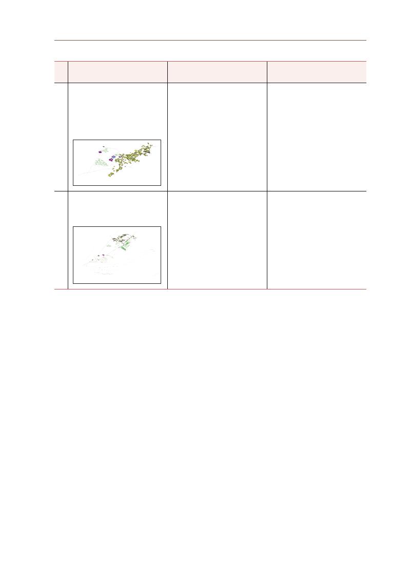
177
Monalisa Bhar
dwaj
Sl
No
Architecture & Planning
Road Network/Temple Street
Observations
3
Talakadu:
A three-temple complex is near
the banks of the river Kaveri, in
the sandy area. The city has many
small temples devoted to Shiva
and a rural landscape, with typical
low-rise pitched roof buildings.
The tour around the three-temple
complex runs along a pedestrian
sand path, making the journey
difficult. After ASI protection was
obtained, a dedicated pathway
with a shaded area was built.
The periodic festival attracts
thousands of people, while
the mythology and beliefs
of Hinduism (e.g., that
Vaidyanatheshwara Temple cures
ailments) and the sandy area
attract tourists from across the
globe.
4
Shivanasamudra:
It is a tranquil rural settlement
with low-rise residential
development.
All the sites in the study area
chosen along the banks of River
Kaveri have narrow streets and
rural landscapes.
The twin waterfalls, which fall
from an altitude of 100 m, the
rural landscape, and Hindu
mythology attract tourists from
across the globe.
The Madhyaranga Temple, part
of a pilgrimage across the banks
of the river, makes this a sacred
place.
A comparison between the selected settlements reveals that they are similar
in terms of the following attributes: scale of settlement, demographics (particularly
religious communities),
historic temples and pilgrimage centers, cultural narratives,
mythological origins, practices, geographies, and the astrological alignments
of sacred seasons. Most of the communities in these settlements show a deep
reverence for the areas’ temple complexes, many of which are disused or
protected monuments, along with riverside ambulation practices. Understanding
the value of cultural factors and the importance people attach to these attributes
can help us revive and protect cultural treasures beyond the boundaries of the
Kaveri region.
8. Conclusion

178
References
Architecture, D. (2008) ‘SUBHASHINI KALIGOTLA A TEMPLE WITHOUT A NAME Deccan
Architecture and the Canon for Sacred Indian Buildings’, pp. 92~113.
Ardawi, M. S. M. and Majzoub, M. F. (1988) ‘Research article’,
Biochimie, 70(6), pp. 749–755.
doi: 10.1016/0300-9084(88)90104-6.
Barnett, L. D. (1926) ‘Reviewed Work: The Kaveri, the Maukharis, and the Sangam Age
by T. G. Aravamuthan’,
Bulletin of the School of Oriental Studies, University of
London, pp. 171~74.
Clare A., Oriole H. (2009) ‘Kaveri basin: its culture, places of historical significance, birth
place, climate, precipitation, catchment, tributaries, state-wise spread, landuse’.
Available at: https://www.indiawaterportal.org/articles/Kaveri-basin-its-culture-
places-historical-significance-birth-place-climate-precipitation.
Charles A. Birnbaum, ASLA, (1994,09), Protecting Cultural Landscapes: Planning,
Treatment and Management of Historic Landscapes, Retrieved from www.nps.gov.
Das A., P. M. (2018) ‘Krishna River Basin. In: Singh D. (eds) The Indian Rivers.’, in
Springer
Hydrogeology. springer, Singapore, pp. 339–351. Available at:
https://doi.org/10.1007/978-981-10-2984-4_27.
Dilip Merala (2017) ‘Kaveri Pushkaralu 2017 Ghats in Tamil Nadu: Best Places to See
Kaveri Maha Pushkaram Celebration’, 17 September.
Enclaves, T. and Nagar, J. P. (2018) ‘Myths and Motives : Kodagu and the Story of the Kaveri
Purana’, 131, pp. 112~131.
Gandhi Rajmohan (2018)
Modern South India: A History from the 17th Century to Our
Times. Aleph Book Company.
Jankiraman, T. (2002)
Eternal Kaveri: The Story of a River. Penguin, India (1993).
K.S. Valdiya, Jaishri Sanwal (2017) ‘Chapter 12 - Mysore Plateau and Nilgiri Massif’,
Developments in Earth Surface Processes, 22, pp. 279~306.
Ka.Vi.Kannan (2019) River Kaveri, the most battl(r)ed. 1st edn. Notion press.
Kiruthiga Kandasamy, T. K. (2019) ‘Holistic urban heritage management of an historic
temple town: Kumbakonam, Tamil Nadu, India’,
Journal of Cultural Heritage
Management and Sustainable Development, 10, pp. 105~121. Available at:
https://doi.org/10.1108/JCHMSD-07-2018-0052.
Nanda, V. (1999) ‘Kumbakonam: the ritual topography of a sacred and royal city of South
India’,
Archaeology International, 3(0). doi: 10.5334/ai.v3i0.182.
Noboru Karashima (2014)
A Concise History of South India: Issues and Interpretations.
New Delhi: Oxford University Press.
Oliveira, V. (2016)
Urban Morphology An Introduction to the Study of the Physical Form of
Cities. springer, Singapore.
Padma Seshadri, Sundararaghavan P.M., (2012)
It Happened Along the Kaveri: A Journey
Through Space and Time. Niyogi books.
R, A. (2014) ‘Understanding the Stability of Early Iron Age folks of South India with Special
Reference to Krishna-Tungabhadra- Kaveri, Karnataka; Their Past-Present-
Future’,
Artha - Journal of Social Sciences, 13(4), p. 47. doi: 10.12724/ajss.31.4.

179
Monalisa Bhar
dwaj
Raghunathan, A. and Sinha, A. (2006) ‘Rockfort temple at Tiruchirapalli, India: Conservation
of a sacred landscape’,
International Journal of Heritage Studies, 12(6), pp. 489504.
doi: 10.1080/13527250600940173.
Ramkumar, M., Kumaraswamy, K. and Mohanraj, R. (2015)
Environmental Management of
River Basin Ecosystems, Springer Earth System Sciences. Available at:
http://link.springer.com/10.1007/978-3-319-13425-3.
Robert Ivermee (2020)
Hooghly: The Global History of a River. C Hurst & Co Publishers Ltd.
Sam Griffiths, A. von L. (2016)
Spatial Cultures Towards a New Social Morphology of Cities
Past and Presen. 1st editio. Routledge. Available at: https://www.routledge.com/
Spatial-Cultures-Towards-a-New-Social-Morphology-of-Cities-Past-and-\
Present/ Griffiths-Lunen/p/book/9781138601666.
Sanyal, S. (2015)
The Incredible History of India. Penguin/Puffin.
Siddaiah, M. (2016) ‘Sacred Complexes as Centers of National Integration: A Case Study of
the Kaveri Basin Area of Karnatka’,
Online Journal of Anthropology, 12(1),
pp. 125~127.
Subrahmanya, K. R. and Prakash Narasimha, K. N. (2017) ‘Kaveri crater – An impact \
structure in the Precambrian terrain of southern India’,
Journal of the Geological
Society of India, 90(4), pp. 387~395. doi: 10.1007/s12594-017-0733-5.
UNESCO World Heritage Centre (2019) ‘The UNESCO Recommendation of the Historic
Urban Landscape. Report of the Second Consultation on its Implementation by
Member States, 2019’, p. 319.
Vetrimurugan, E., & Elango, L. (2014). Groundwater Chemistry and Quality in an Intensively
Cultivated River Delta.
Water Quality, Exposure and Health, 7, 125-141.
Vikram, S. (2008) Splendours of Royal Mysore. New Delhi: Rupa Publications India Pvt.Ltd.
Wujastyk, D. (2006) ‘Thanjavur Library as a Realm of Knowledge’,
Kriti Rakshana, 1(4),
pp. 1315.
This research was funded by the 2021 UNESCO Chair Research Grant Project of the Korea
National University of Cultural Heritage.
The authors extend gratitude first and foremost to the Korea National University Cultural
Heritage UNESCO Research Grant Committee for extending the support and funds to
undertake the research on settlements of river Kaveri in South India.
The authors wish to thank the Principal, Dr N.V.R. Naidu, Ramaiah Institute of Technology,
Bangalore who has been a continuous support and guidance. The authors also thank the
Head of Department and the colleagues at department of Architecture, Ramaiah Institute
of Technology, Bangalore for their continuing support and encouragement.
The authors also thank the anonymous participants in field study from context areas- who
gave invaluable inputs, and helped shape this research. The authors also thank the editors
who have diligently contributed to improving the draft.
The authors wish to thank their family and friends for their constant support.
Acknowledgements

This research attempts to understand the history of the traditional use of
lacquers in Cambodia by focusing on the characteristics of Khmer lacquers,
lacquer specialization, and lacquers as authentic material for cultural heritage
conservation. The information gained from reviewing lacquer research literature,
examining ancient lacquer remains, reviewing old epigraphy, and conducting
ethnographic surveys enriches our knowledge of lacquer and its traditional use
in Cambodia. Natural lacquer sap is tapped yearly from two lacquer tree species
growing in Cambodia:
Gluta usitata and Gluta laccifera. The knowledge of using
a lacquer can be traced back to a very remote period. The first historical record
of lacquer work dates back to the 10th century, when King Jayavarman V (AD 968-
1001)
established a royal corporation of
khmuk, a mixture of lacquer with I leaves,
for use in use the holy chamber of worship, supervised by a chief of khmuk and
some members under a royal directive, and supported by domestic products
and land revenues. The post-Angkorian lacquer sculptors used benzoin gum,
dammar resin, clay, ash of rice husks, sand, and other sediments to mix with
the lacquer to make a lacquer-based mortar. This lacquer mixture was used
to mold, coat, and repair Buddha statues and other sculptures before applying
cinnabar/vermillion, mercury, and gilding. The queen mother of a 16th century
king in Cambodia sacrificed her holy hair bun and burned it to make a sacred
khmuk for the erection of Angkor Wat’s Buddha statues. This sacrifice was
obviously not for technical purposes, but rather from a pure heart of devotion
and respect given to the Buddha and Buddhism. The tradition of harvesting
lacquer sap and using it for the fabrication of artistic and daily objects still exists
among rural communities in Cambodia, but it has significantly declined because
the time, labor, and resources consumed for lacquer work do not provide a good
Vanna LY Head, National Committee for the World Heritage of Cambodia
Traditional Use of Lacquer in Cambodia
Abstract
Survey Research Papers on UNESCO Chair Research Grant
06

181
Vanna L
Y
living income. Based on several tests, lacquer is considered an authentic and
perfect traditional material for conserving stone sculptures coated with lacquer
and polychromes in Cambodia. The first attempt to use natural lacquers in stone
conservation work in Angkor was made during the conservation of the statue
of Ta Reach at Angkor Wat in 2005 and the post-Angkorian Buddha statues
in the central shrine of Pre Rup in 2020. Although this preliminary research
has enriched our knowledge of the history of the traditional use of lacquers in
Cambodia, further scientific research on the ancient composition of lacquer
and lacquer mixtures from various historical and cultural contexts needs to be
considered in the future.

182
Lacquer, or mrāk to give it its local name, is generally known to almost
all Cambodian people because the tradition of using lacquer to make artistic,
decorative, ritual, and daily life objects is still practiced. However, most
Cambodians do not know the history of lacquer work and hardly recognize the
lacquer tree (local name, kreul), or the traditional practice of harvesting lacquer
sap and using its resin. The tradition of tapping lacquer trees and using lacquers
to produce crafted objects faces a great decline because the income obtained
from selling traditional lacquered objects does not compensate for the cost
of producing lacquer work. Only a few households in the villages of Trea and
Pralay in Kampong Thom province, central Cambodia, continue to practice their
traditional lacquer work. Most cultural heritage conservators in Cambodia are
not familiar with this precious and valuable material and do not know when
lacquer was used, what are the constituent components of lacquer and lacquer
mortar, and how these materials are applied in traditional craft and architecture.
The remains of various types of lacquer and lacquer mortar are found in the
16th-17th century sculpture in Angkor and elsewhere in Cambodia, either used
in production or restoration. However, no investigation has been conducted thus
far on these traditional materials.
This research attempts to collect all relevant information that can help us
understand the history of traditional lacquer use in Cambodia by focusing on
three major themes: characteristics of Khmer lacquer, Lacquer specialization
in ancient times, and Lacquer as authentic material for cultural heritage
conservation. In the section on the characteristics of Khmer lacquer, a number
of subthemes will be examined - lacquer trees, lacquer sap harvesting,
lacquer sap, and lacquer in medicinal use–are examined. The section on
lacquer specialization will present various pieces of information and evidence
on Angkorian royal lacquer corporations, the use of lacquers in Angkorian
and post-Angkorian times, and sacred lacquers in religious and ritual
contexts. Lacquer as authentic material for cultural heritage conservation is
also preliminarily documented and applied for the first time in Angkor. The
methodology adopted for this research includes 1) reviewing the epigraphical
records of Angkorian times: eleven inscriptions are identified that record
lacquer-related work and royal lacquer corporations during the reign of King
Jayavarman V; 2) investigating ancient lacquer and lacquer-based mortar
remains left on the walls of Angkorian temples and sculptures; 3) conducting
an ethnographic survey on lacquer sap harvesting and lacquer craftmanship at
Trea villager in Kampong Thom province, central Cambodia; and 4) conducting a
lacquer-related literature review.
1. Introduction
183
Vanna L
Y
When reviewing published articles on lacquer species in Southeast Asia,
we could differentiate some basic characteristics of Khmer lacquer from
other lacquer species in Asia by examining lacquer tree species, lacquer sap,
techniques of lacquer sap harvesting, and other parts of lacquer trees that have
been used in traditional medicine by local villagers.
2-1 Lacquer Trees
More than 73 genera and 600 species of lacquer trees worldwide are
classified into the Toxicodendron genus of the family Anacardiaceae. Most of
them grow in the subtropical environment of Southeast Asia, and a few grow in
the evergreen forest of East Asia [1]. Two botanical species of lacquer trees are
recognized in Cambodia:
Gluta usitata (Wall.) Ding Hou [1, 9] and Gluta laccifera
(
Pierre.)
Ding Hou [9, 2]. These two species also grow widely in Myanmar, Laos
Thailand and Vietnam [9, 2].
Gluta usitata (Wall.) Ding Hou grows in a deciduous
dipterocarp forest [1, 2, 3, 4, 9] at an altitude of 100m to 1000m above sea level
and to a height of 5–25m [3, 4], whereas
Gluta laccifera (Pierre.) Ding Hou grows
densely on quaternary sedimentary rock and alluvial sandy plains in Cambodia
[5, 6],
at an altitude of 10 to 600m [7] and to a height of 18m [3] to 25 or 30m [8]. A
recent survey conducted in Kampong Thom province showed that from 2014,
less than five trees were counted within a plot of 30 x 80m, and the 50–60cm
diameter at breast height (DBH) trees were cut for timber [6] (Figure 1).
Figure 1. Lacquer trees growing on a sandy alluvial plain in the rice field of Trea village,
Stong District, Kampong Thom province, central Cambodia (Author 2021)
2. Characteristics
of Khmer
Lacquer

184
2-2 Lacquer sap harvesting
Several factors affect the quality and quantity of lacquer sap
harvested. These conditions include meteorological conditions,
growth environment, tree species, tree age, harvest season, and
tapping techniques. During extended periods of sunshine and high
temperatures, the lacquer yield increases and reduces with an
intensification of rainfall, low temperatures and shorter periods of
sunshine [1]. Generally, a lacquer tree can yield its sap after five years
of growth if the bark thickness grows quickly. However, for species
whose bark thickness develops slowly, it takes up to 10 years growth [1].
According to Rong Lu and Tetsuo Miyakoshi, the harvesting of lacquer
sap is usually carried out three times a year [1]. The first collection is
from mid-June to early July, when the harvested lacquer sap contains
a lot of water and has a high viscosity. The second is from mid-July
to late August, when the life activity of a lacquer tree is healthy, sap
secretion is strong, yield is high, and quality is good. The third is from
early September to early October, during which time the temperature
decreases, and transpiration weakens the laticiferous canal cell
activity, decreasing the secretion. The lacquer collected at this time has
a light color and low lipid concentration [1]. Various tapping techniques
have been recorded. Horizontal incision is recognized as popular in
Japan; oblique and vertical incisions are mostly practiced in Myanmar
and Thailand, while in Cambodia, China, Myanmar, and Vietnam, egg-
type incisions and V-shaped incisions are the most popular tapping
techniques (Figure 2). The Cambodian lacquer tappers of Trea and
Pralay villages use an iron spatula-shaped incising tool to incise the
Figure 2. Various types of incisions
adopted for tapping
lacquer sap [1]
Figure 3. a. A spatula-shaped tool
with sharp edges for
cutting and opening the
barks for inserting the
collecting bamboo tubes
(
Author Sept. 2021). b.
Cutting the bark of a
lacquer tree (Author
Sept. 2021). c. barks
cut into a V-shaped
type (Author Sept.2021).
d. collecting sap by
inserting the bamboo
tube into the cut bark ([2])
Figure 4. The ethnographic record of Mr Chik Prak, describing a lacquer sap
tapping process in 1948 [24]

185
Vanna L
Y
lacquer bark into a V-shaped cut and insert it to collect the sap [2] (Figure 3).
In Cambodia, lacquer sap harvesting techniques are diverse and differ from
one region to another or from one generation to another. An old ethnographic
record written in Khmer, dating back to 1948 (Figure 4), is the oldest piece of
literature on lacquer harvesting I encountered during my documentary research,
and it is worth summarizing as follows:
“
Pithi Thveu Mrāk Khmae,” a ritual for the fabrication of Khmer lacquer. The
harvesting of lacquer sap is not possible in all seasons. The best season is from
September to January, when the growing activity of the lacquer trees is strong,
with healthy and mature leaves and fruits. The yield is high, and the sap quality
is particularly good. The tools for collecting the sap are an iron tool with a curved
incising edge to cut the tree bark, a ladder, a gutter, and a bamboo tube. The
tapping starts by cutting the tree bark with the incising tool, inserting the gutter
into the incised area, and then connecting the bamboo tube to the gutter. Usually,
approximately 15 to 17 tubes are used to collect the sap, over 7 to 8 days after the
tappers come to collect the sap, and then are moved to tap again in other new
locations on the tree’ [24].
2-3 Lacquer Sap
It has been reported that lacquer is the only self-catalyzing natural polymer,
and no organic solvent evaporates (only water) during the drying process.
Therefore, because of this self-drying system, a natural lacquer is a precious
coating material with solvent-free and high-solid-content components [1]. When
the bark of a lacquer tree is mechanically injured, its milky white sap comes
out of the tree, and a few minutes later, the sap becomes dark brown to black
after oxidation [1, 2] (Figure 5). Skin contact can cause severe dermatitis in some
people due to its catechols [2, 4, 10]. Lacquer sap contains 60%–70% catechol
derivatives, 20%–30% water, 4%–10% plant gum, 3%–5% glycoproteins, and
1.5 to 2% of enzyme laccase [12]. Thitsiol is the main component of lacquer sap
tapped from both species. The sap sampled from Cambodia does not contain
C10 phenyl catechol, whereas the sap from Myanmar contains both C10 and C12
phenyl catechols [2]. In general, additives and solvents are added to the lacquer
to prolong its fluidity and improve its workable state. The best lacquer is black,
but if the water content in the lacquer reaches 30%–45%, the lacquer sap has a
brown, yellow or red color [2].
It has been reported that thitsiol lacquer is more viscous than other
lacquers; therefore, other wood oils or plant oils are added to the lacquer [2].
Other oils, such as peanut or tung oil, are also used when making a colored
Figure 5. lacquer sap
exudes from the
injured bark of
a lacquer tree
at Trea Village,
Kampong Thom
province (Author,
Sept. 2021)

186
lacquer, especially when vermillion is used [2]. Contemporary lacquer workers
or artists add ashes from burned old cloth, palm or banana leaves [14, 25, 26], rice
husk ash, talcum [2], petrol, red iron, titanium, sandstone powder, and resin of
Ficus benjamina [26, 30] to the natural lacquer to make a variety of lacquer pastes
for different purposes.
Lacquer is widely used in the chemical and petrochemical industries,
shipbuilding, and crafts [1]. Therefore, it is evident that its utilitarian diversity
requires various specific skills in its application for different purposes. This
section presents various pieces of information on lacquer works since ancient
times in Cambodia.
3-1 Angkor Royal Lacquer Corporation
When reviewing old Khmer epigraphy, we come across a strikingly important
record of the establishment of a royal corporation of lacquer. At this stage
of the research, we identified a number of old Khmer inscriptions: K.168 [31],
K. 868 [32], K. 175 [33], K.444 [34], K.814 [35], K.1152 [36], K.1198 [37], K.465 [15],
K.715 [14], and K.302, K.303 of IMA2&3 [13]
mentioning khmuk1 related stories.
Among these inscriptions, one inscription (K.168) mentions a person named
gho
khmuk [31], five inscriptions (K.175, K. 444, K. 868, K. 1152, K. 814) tells us that King
Jayavarman V (AD 968-1001) established a new “
varna” or corporation of khmuk
professionals attached to the chamber of cult “
kralā arcanā” of the royal palace
[37],
one inscription (K.1198) reports that a group of persons were ordered by King
Suryavarman I in AD 1014 to enter into the service of
khmuk of the chamber of
the cult [37] and the other four inscriptions (K.456, K.715 and K.302, K303 of IMA2&3)
are not related to the Angkorian
khmuk corporation but to the repair of broken
Buddha statues at Bakheng and Udong by a monk [15], the sacrifice of her holy
hair bun by the queen mother of a 16th century Khmer king to make
kmuk2 [13]
for the erection of the Buddha statues at Angkor Wat, and the sacrifice of a noble
man’s hairs, eyebrows and chest hairs to make kmuk for the construction of a
Buddha statue [14].
Here are the old Khmer inscriptions that mention the royal corporation of
khmuk during the reign of Jayavarman V: K.444A:163 (AD 974); K.868A:9-10 (AD
974):
⋯
duk mūla khmuk vrah kralā ’arccana 20 mūla karmmāntara 20⋯ (⋯ to
appoint a chief [and] twenty
khmuk of the holy chamber of worship [and] a chief [and] twenty
members of the Karmmāntara Order4 ⋯)
[16].
3. Lacquer
Specializations
1
“
Khmuk”, in modern
Khmer, is a mixture of
lacquer with burned
banana leaves or cloth;
It also means to paint
with this mixture, but
also to be smashed to
little pieces; crushed,
pulverized, broken. It is
a black undercoating
applied to images before
gilding; it could be also
the artisan who applies
this undercoating [17].
2 This word is written as
“
khmuk” in the 10th and
11th centuries and today,
and as “Kmuk” in the
16th century.
3
K.444A:16 presented here
indicates the inscription
numbered K.444, face A,
line 16.
4
“
Karmmāntara”, a
Sanskrit word, is meant:
a varna or clerical order
responsible for funeral
rites [17].

187
Vanna L
Y
K.444A:17-9; K.868A:10-1: ⋯
phle sruk sre bhūmyākara le ʼn siddhi jā varna
neh ta vyar nā khmuk vrah kralā ’arccana nu karmmantāra ⋯ (⋯ the produce of
the
sruk, the rice land, [and] land revenues in full title as members of these two corporations,
the parent departments (
n
ā) of the khmuk of the holy chamber of worship, and
members of the Karmmāntara Order) [16].
K.444A:21-3; K.868A:13-4: ⋯
phle’anvaya neh nā khmuk vrah kralā ’arccana
nu karmmāntara yāvat vrah candrāditya mān dau (⋯ the yield [accruing] from these
sources shall be for (
n
ā) the khmuk of the holy chamber of worship and members of
the Karmmāntara Order for as long as the sacred moon and sun shall shine) [16].
K.444A:24-5; K.868A:15: ⋯
khloñ khmuk vrah kralā ’arccana nu khloñ
karmmāntara ⋯ (⋯ the chief of the khmuk of the holy chamber of worship and the chief of
members of the Karmm
āntara Order ⋯) [16].
K.1152B:6 (AD 977): ⋯
pandval vrah śāsana [ta] steńń khmuk vrah kralā
’
arccana ⋯ (⋯ to issue a royal directive to the steń of the khmuk of the holy chamber of
worship ⋯)
[16].
K.814A:66-8 (AD 1004):
steń ’añ ’ācāryya homa ta khmuk vrah kriya [= kralā]
’
arccana ⋯ (The steń ’añ the instructor of sacrifice, a khmuk of the holy chamber of worship ⋯)
[16]
We have seen that the royal corporation of the
khmuk of the holy chamber of
worship is managed by a chief and 20 khmuk professionals assigned by the king,
working under a royal directive and supported by domestic produce, rice land,
and land-revenues. It is presumed that this royal corporation might have been
composed of a group of lacquer specialists working on fabricating lacquered
accessories for the holy chamber of worship of the royal palace.
3-2 Lacquer as Coating Material
Lacquer is a fascinating coating material used in human life for thousands
of years [1]. Based on the results of recent investigations on lacquer remains
of the Buddha statues of Pre Rup [18], the wooden Buddha from the Angkor
Conservation [17], the Buddha statues at the “Gallery of a Thousands Buddha”
of Angkor Wat, and the polychrome remains on the bas-reliefs of Angkor Wat
[23],
in combination with observations of the pre-Angkorian Buddha statue from
Wat Kampong Luong during a restoration intervention at the stone conservation
workshop of the National Museum of Cambodia [20], we have verified that
lacquer was used as an undercoat on stone statues and carvings before applying
other polychromes and gilding. This information is compatible with the records
of the 16th-century inscriptions from the Angkor region [13, 14, 15, 16]. We have
c
d
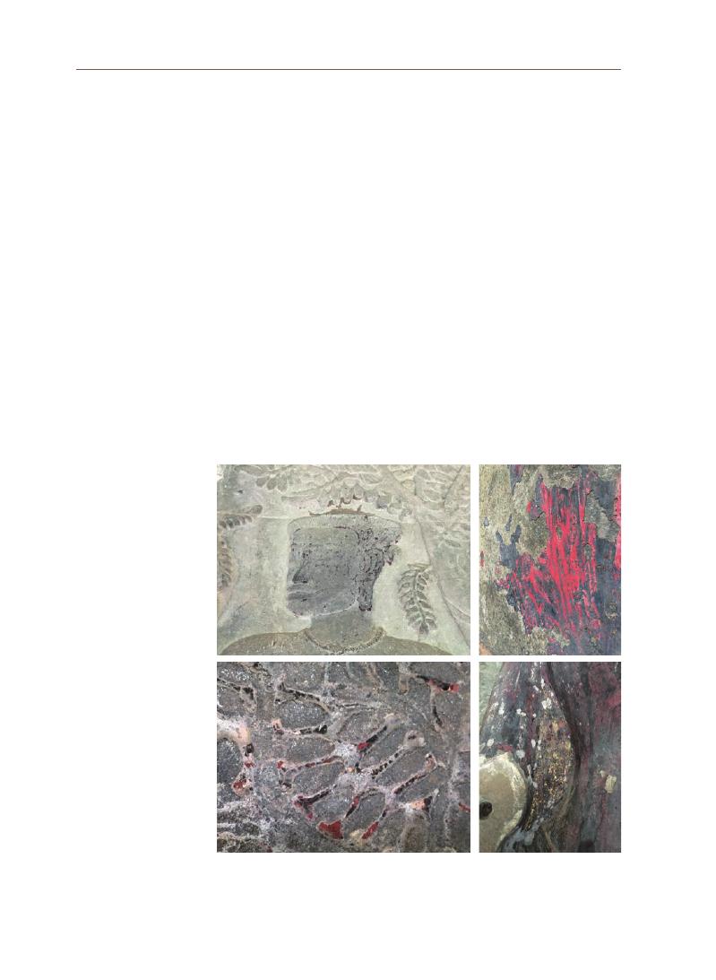
188
learned from these epigraphical records some technical words such as “
khmuk”
(
10th century)
[16], “
kmuk,” a mixture of lacquer with additives, “hingulā,” cinnabar/
vermillion, “
pāratt,” mercuric sulphide (16th century) [15], “pit mās,” gilding (17th
century)
[14], that indicate a technical process starting from coating with a lacquer
mixture or “
kmuk,” then applying cinnabar/vermillion, and gilding or decorating
ornaments. The same technical process has also been applied to wooden
statues [17].
In some sections of the bas reliefs of Angkor, especially on the historical
panel of King Suryavarman II, some lacquer remains are still visible. The bas
reliefs were coated with black lacquer layers beneath the red and gilded layers
(
Figure 6).
These lacquer remains have been provisionally dated back to the 12th
century, whereas other polychromes containing no lacquer might have dated
from the 16th century onward [23].
Another example that clearly shows several layers of lacquer coatings made
in different periods on the same sculpture is the Buddha statue of Wat Kampong
IV
III
II
I
Figure 6. a & b. Black traces left in carved motifs are the remains of black lacquers
overcoated by red polychrome gilded, Southwestern bas-reliefs-gallery of
Angkor; c. lacquer overcoated with red polychrome Vishnu statue, 3rd floor,
southern gallery, Angkor Wat, d. lacquer and polychrome gilded of a Buddha
statue from the Gallery of Thousands Buddha, Angkor Wat (Author, Oct. 2021)
a
c
b
d
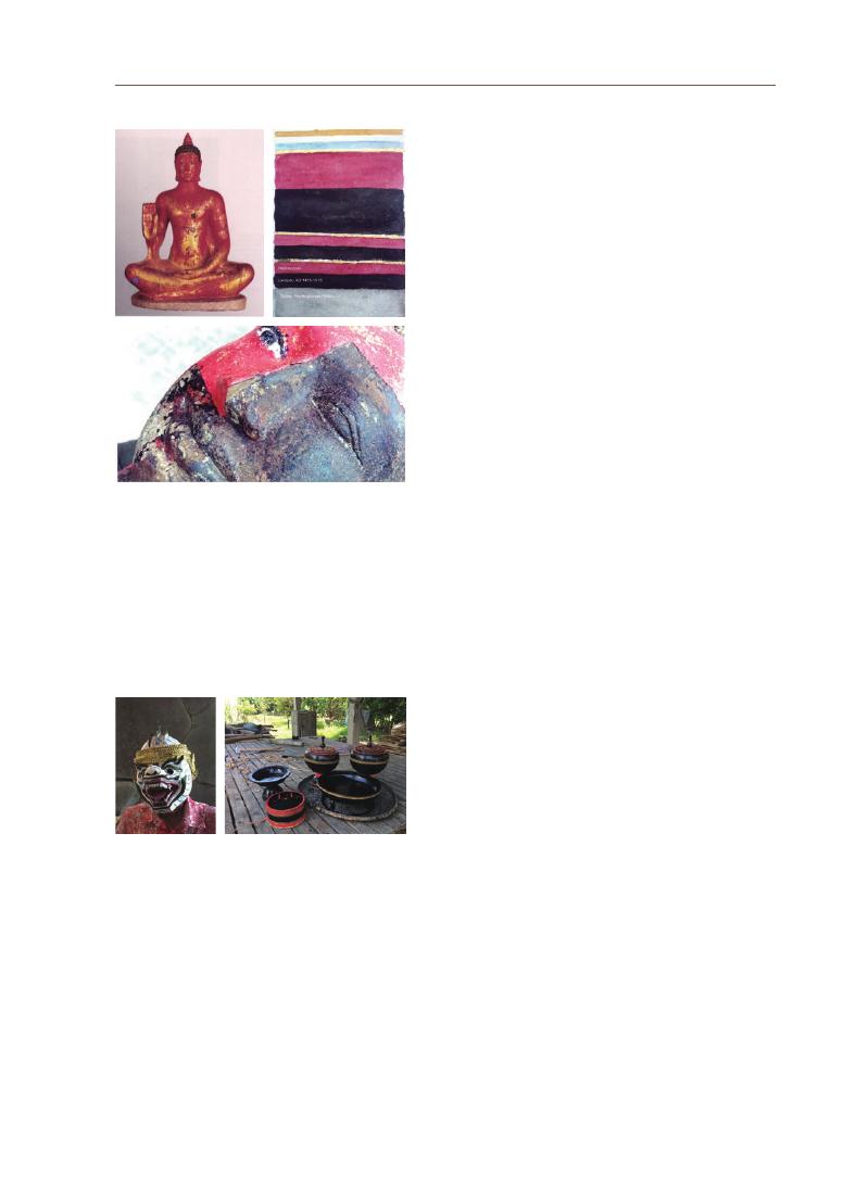
189
Vanna L
Y
learned from these epigraphical records some technical words such as “
khmuk”
(
10th century)
[16], “
kmuk,” a mixture of lacquer with additives, “hingulā,” cinnabar/
vermillion, “
pāratt,” mercuric sulphide (16th century) [15], “pit mās,” gilding (17th
century)
[14], that indicate a technical process starting from coating with a lacquer
mixture or “
kmuk,” then applying cinnabar/vermillion, and gilding or decorating
ornaments. The same technical process has also been applied to wooden
statues [17].
In some sections of the bas reliefs of Angkor, especially on the historical
panel of King Suryavarman II, some lacquer remains are still visible. The bas
reliefs were coated with black lacquer layers beneath the red and gilded layers
(
Figure 6).
These lacquer remains have been provisionally dated back to the 12th
century, whereas other polychromes containing no lacquer might have dated
from the 16th century onward [23].
Another example that clearly shows several layers of lacquer coatings made
in different periods on the same sculpture is the Buddha statue of Wat Kampong
IV
III
II
I
Luong from Angkor Borei, Southern Cambodia. This
7th-century pre-Angkorian statue is made of sandstone
in the Phnom Da style. The statue underwent several
modifications in the past, and it was difficult to recognize
its original appearance and state of conservation [20].
In 2000, the studio of stone restoration at the National
Museum of Cambodia initiated a de-restoration (Figure
7a and 7b).
The stratigraphy of successive coated layers
revealed a thick complex coating composed of four
coating phases, as shown in the schematic stratigraphy
(
Figure 7c).
The first phase consists of a black lacquer
coating that is directly applied to the stone surface; the
red lacquer, the gilded layer (yellow), dated to the 15th-
16th centuries or AD 1415-1515, the second and third
are thicker, probably dated to the 19th century; and the
fourth is the new synthetic painting [20].
It is not known when it ceased, but the tradition
of using lacquer in stone and wooden architecture,
conservation, restoration, and other construction
domains in Cambodia is no longer practiced. This is
perhaps because the collecting of the lacquer is a
manual rather than a mechanical operation. Added
to this is the possibility of lacquer allergy, and the fact
that lacquer trees grow in remote and inconvenient
areas, and lacquer sap is expensive [1]. An ethnographic
record from 1948 reports that lacquer is traditionally
used to coat and make bowls for Buddhist monks [25],
water bowls, betel boxes, and so on, as well as to coat
the manuscripts and pillars of pagodas or as drawing
material [24]. This tradition continues, even though it
is facing a significant decline, among local lacquer
communities, especially in Trea and Pralay villages, Kampong Thom province,
central Cambodia (Figure 8b) [26], and among modern lacquer artists who produce
art objects [11], especially the masks of dancers of the Monkeys or “
khol” theatre
(
Figure 8a)
[28].
Figure 7. a. The appearance of the Buddha statue
after the first partial restoration in
2000, b. Sectioning of successive coated
layers revealed after de-restoration, c.
Schematic stratigraphy of four phases of
coated layers: Phase I (16th century) and
II (19th century) are very fine, less than
1mm, Phase III (20th century) is very thick,
3mm to 1cm, and Phase IV is the new
synthetic painting (Photos of [21])
Figure 8. a. A mask of the monkey dancer, made
of paper and lacquer, b. Trays and betel
boxes made from palm tree’s branches
and coated with lacquer of a lacquer
craftsman from Trea village (Author, 2021)
a
b
c
b
a
190
3-3 Absence of Lacquer in Polychrome of Brick Temples
A preliminary research report was compiled on anicent paintings and
polychromic remains in ancient Khmer brick temples in Cambodia. An inventory
of 105 brick towers of 19 temples from the 9th to 10th centuries, was made, and
43 towers were confirmed to have paintings and polychromic remains in situ
on the interior walls (Figure 9) [21]. The scientific analysis of the pigments from
these paintings and polychromic remains revealed that the black pigments are
aluminum silicates with manganese and iron oxides as coloring components.
Kaolin clay pigments and cinnabar were also used to make white paint and red
layers, respectively [21]. To detect distinctive components of the binding medium,
the research team used the Fourier transform infrared spectroscopy (FT-IR)
technique to analyze the samples, and it was confirmed that the intensely strong
peak at 1694 cm-1 was assigned to carboxylic acid, which is highly likely to match
the spectrum of kauri copal gum, but not that of lacquer [21]. Therefore, lacquer
has not yet been confirmed as having been used either in painting or polychrome
remains of ancient Khmer brick temples.
3-4 Absence of Lacquer in Other Polychromic Remains of Angkor
Wat
It is doubtful that lacquer was extensively used to coat, to mold, and to repair
the Buddhas and other statues in the 16th century in Cambodia, but it was not
present in other polychromes of Angkor Wat, especially the polychrome remains
found in the cruciform gallery and corner pavilions of Angkor Wat. Two scientific
Figure 9. Floral decorative designs of light orange, red and black colors, interior south
wall of Prea Ko temple, 9th century (Photo of [23])

191
Vanna L
Y
studies on the polychrome remains of these locations in Angkor Wat were
conducted in the past [22, 23]. The results of the analysis revealed that red iron
oxide, black pigment (12th century), red lead, cinnabar, white ochre (16th century) [23],
white lead, iron hydroxide, lead oxide, and carbon black [22] were used to paint
the interior wall surface, columns, corniches, door frames, beams, and half-
vaults of the cruciform gallery of Angkor Wat. Therefore, the use of a lacquer
to coat the interior surface and other architectural elements of the cruciform
gallery and corner pavilions of Angkor Wat has not yet been confirmed.
3-5 Lacquer as Gluing, Refilling, Molding
Material
Apart from being used as a coating material, lacquer
mixed with other organic and inorganic additives to make
a lacquer-based mortar is used to glue broken stones,
refill the gaps or void areas on the stone, and mold or
shape the statues. The lacquer mortar used to shape the
Buddha statues of Pre Rup contains thitsiol, dammar
resin, bone, and sediment, whereas benzoin gum,
sand, and sediments are mixed with lacquer for gluing
ornaments and stone [18] (Figure 11). Other examples
include the post-Angkorian Buddha statues and other
divine statues at the “Gallery of a thousand Buddhas” of
Angkor Wat and other temples in Cambodia (Figure 12).
Figure 10. a & b. Pillars, beams, corniches, door frames, pilasters and vaults of the cruciform gallery painted in red,
black and white colors, Angkor Wat (Author, 2021)
b
a
Figure 11. A post-Angkorian Buddha statue of
Pre Rup: After cleaning off the dirt
and debris, various types of lacquer
mortars are exposed. Four types of
lacquer mortars are recognized -
lacquer mortar for gluing, for filling,
for shaping or molding, and for coating
(
Author, 2020)
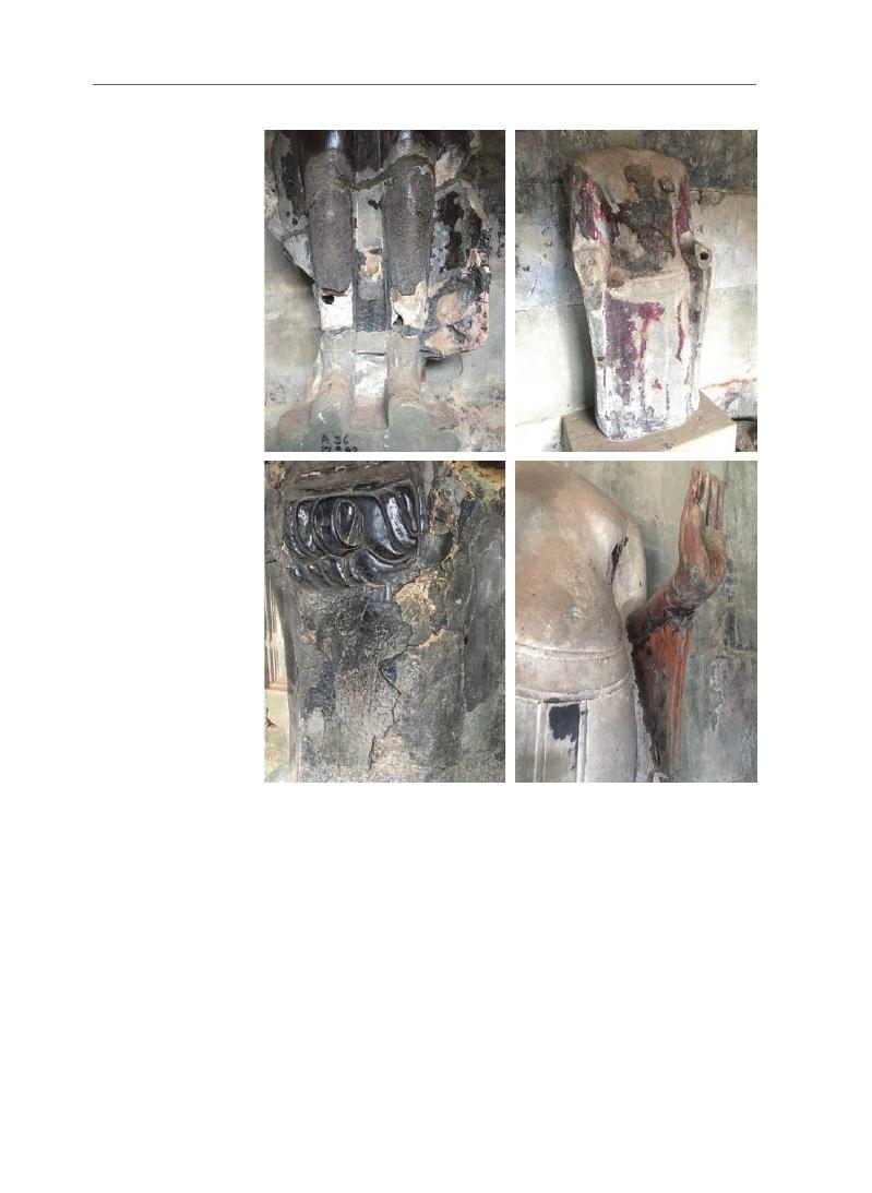
192
3-6 Sacred Lacquer
Two remarkable epigraphical records of the post-Angkorian period
mention the sacrifice of human hairs to make a sacred lacquer “
kmuk.” The first
inscription (K. 303) from lines 18 to 21 (Figure 13) recounts that Mahākalyānavattī
Çrīsujātā, the Queen Mother of the 16th century Khmer King, Jayachetha I, within
her pure royal heart of devotion and respect to the Buddha and Buddhism,
shaved her head and received a ritual ablution,
muddhābhisek. The shaved hairs
were burned into ash then mixed with lacquer resin to make “
kmuk” for the
b
Figure 12. a. the upper section of the legs is made of lime mortar and covered by lacquer
mortar; b. the front of the statue’s body is shaped in lacquer mortar; c. the
statue’s ornament and skirt are molded in lacquer mortar; d. the statue’s arm
is made of wood coated with lacquer and polychrome connected by the stone
body by lacquer mortar. Three statues (a, b, d) are housed in the 1000 Buddha
Gallery, and the Vishnu statue (c.) in the 3rd southern gallery (Author 2021)
b
d
a
c
193
Vanna L
Y
3-6 Sacred Lacquer
Two remarkable epigraphical records of the post-Angkorian period
mention the sacrifice of human hairs to make a sacred lacquer “
kmuk.” The first
inscription (K. 303) from lines 18 to 21 (Figure 13) recounts that Mahākalyānavattī
Çrīsujātā, the Queen Mother of the 16th century Khmer King, Jayachetha I, within
her pure royal heart of devotion and respect to the Buddha and Buddhism,
shaved her head and received a ritual ablution,
muddhābhisek. The shaved hairs
were burned into ash then mixed with lacquer resin to make “
kmuk” for the
b
erection of the Buddha statues of the central shrine of Angkor Wat [13, 29].
Another inscription (K.715) from the mountain of Kulen in the northern region
of Angkor (Figure 14) says a noble man named Māhākosal came to venerate the
Grand Buddha of the site, sacrificed his hair, eyebrows, and chest hairs, burned
and boiled them to make a lacquer “
kmuk” for the repair of the Grand Buddha
statue of the site [14].
The religious act of abandoning the hair bun of the queen mother, and of
the hairs, eyebrows and chest hairs of the noble man, is not obviously related to
the technical aspect of lacquer “
kmuk” for the repair or erection of the Buddha
statues but rather to the sacrifice and devotion to the Buddha and Buddhism in
particular.
Recent investigations of traditional materials have revealed that lacquer is
among the traditional materials used in ancient Cambodia in the field of plastic
arts. Lacquer remains either in lacquer finishes, lacquer adhesive, or lacquer
mortar, allowing us to understand its physical and compositional attributes,
and its involvement with human life from other sociocultural aspects. Modern
experts or conservators of cultural heritage, in general, still concentrate on
using industrial products, materials, and modern technology, as they believe that
those materials are strong, safe, and durable. However, they have not studied
the consequences of the weakness or adverse impacts of these materials after
their introduction into ancient structures or materials. An attempt to use natural
lacquer and other materials combined with lacquer for the conservation and
4. Lacquer as
an Authentic
Material
for Cultural
Heritage
Conservation
Figure 13. Inscription of K.303 of
Angkor Wat, from lines 18 to
21mentioning the sacrifice
of the saint chignon of the
queen mother in the 16th
century to make “
kmuk”
(
Photo, [39], Transliteration
of [14])
Figure 14. K.715 recounting the sacrifice of
head hairs, eyebrows and chest
hairs to make “
kmuk” for the repair
of the Grand Buddha of Phnum
Kulen in 16th century (Photo and
transliteration, [15], translation,
[28])
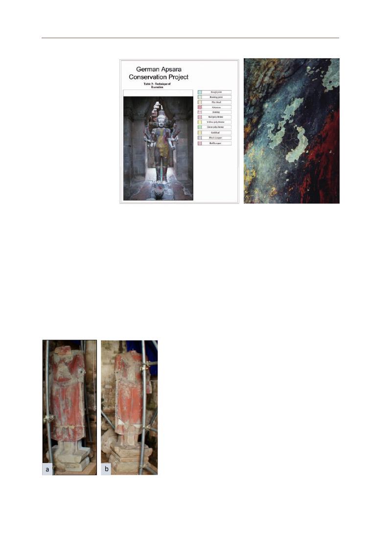
194
restoration of traditional lacquered objects, especially stone sculptures partially
made of or coated with lacquer, has not been widely considered in Cambodia.
The first trial of using a natural lacquer was when the Vishnu statue or Ta
Reap of Angkor Wat was restored in 2005. After several tests, it was observed
that the natural lacquer was perfect for sealing or gluing small cracks or
lacunae more than half a millimeter in thickness, but it was too viscous to
infiltrate into smaller cracks. Therefore, a mixed method was adopted by using
about 5% Paraloid B72 to inject into the finer scales to adhere
them, and then using a lacquer to seal or fill the cracks [19]
(
Figure 14).
The second successful challenge was in the conservation
and restoration project of the post-Angkorian Buddha
statues at Pre Rup temple in Angkor in 2020, carried out by a
Cambodian conservation team under the technical instruction
and supervision of a lacquer conservation specialist from
Stocker Studio in Siem Reap province, Cambodia. After
several tests, the lacquer conservation work started with
the following main procedures: 1) Using the raw lacquer
containing 80% resin and 20% water mixed with petrol to
cover the gaps (95 g raw lacquer and 5 g petrol). 2) Applying the
well-mixed liquid with a brush onto the repaired surface, then
Figure 15. The mapping of degrees of preservation conditions of the polychromy of the
statue before intervention (Photo on the left), and the scaling and cracks of
polychromy and lacquer layers (Photo on the right) (Photo of [20])
Figure 16. Two post-Angkorian Buddha
statues of Pre Rup ready for
lacquer conservation intervention
(
SUC, 2020)
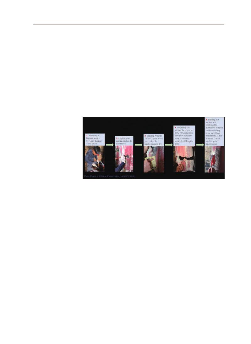
195
Vanna L
Y
coating the areas filled by the solution of raw lacquer and petrol with a refined
lacquer using a brush and drying for 3 to 5 days. 3) Sanding the refined lacquer
with 240-320 grain sized sandpaper and cleaning off the dust. 4) preparing the
surface to receive pigments by applying a lacquer mortar (60%-70% sandstone dust
of the appropriate color tone identical to that of the original colors of the statues, mixed with
40% of raw lacquer)
onto the pigments-received areas, and keeping it dry between
5 and 10 days. 5) Sanding the surface and applying a mixture of red iron oxide
powder with the sap of
Chrey Krem (Ficus benjamina) for adhesiveness to obtain
the color. White titanium pigment was also used to obtain a smoky color tone [30]
(
Figure 16 and 17).
Lacquer research in Cambodia is still underdeveloped compared to other
Asian countries. This preliminary research is just a starting point to collect
general information or evidence that we had encountered through a lacquer-
related literature review, a study of lacquer remains, reading epigraphical
records, and conducting ethnographic research. The results obtained at this
stage of research allowed us to draw the following initial conclusions:
Lacquer might have been used in Cambodia in remote history, even
though there is no archaeological evidence. However, lacquer trees growing in
Cambodia on the sandy and alluvial plains within deciduous dipterocarp forests
have already suggested their presence in geobotanic history in this part of the
world. The interaction between lacquer and human life is obvious when humans
realize and understand the important values and advantages of lacquer trees
and lacquer saps in their lives. The knowledge obtained from the study of ancient
5. Initial
Conclusions
Figure 17. Summary of the major steps of lacquer conservation and restoration
intervention adopted for the post-Angkorian Buddha statues at Pre Rup
temple in Angkor. The work was executed by the young professional Stone
Conservation Unit under the instruction and supervision of the technical
coordinators of GIZ and of the lacquer master of Stocker Studio, Siem Reap [31].

196
polychrome and lacquer mortar components remaining on the pre-Angkorian
Buddha statue of Wat Kampong Luong, the survey of lacquer remains on the
12th century bas-reliefs of Angkor Wat, the conservation documentation, and
scientific analysis of lacquer remains of the post-Angkorian Buddha statues in
the central brick shrine of Pre Rup in Angkor, the study of lacquer work-related
epigraphical records in combination with the ethnographic survey at the lacquer
crafts village of Trea in Kampong Thom province, all allowed us to understand
not only the history of traditional lacquer work but also the diversity of lacquer in
its social, cultural, religious values and in its nature as a traditional and authentic
material for cultural heritage conservation in Cambodia.
Early historical records of lacquer work in Cambodia were found in the
10th century Angkorian inscriptions when King Jayavarman V (AD 968-1001)
established his royal corporation of lacquer for the holy chamber of worship,
but the tradition of using lacquer was probably older than that. As seen in this
research, lacquer has multiple functions, including coating, gluing, refilling,
molding, and decorating material in the domain of traditional lacquer crafts, and
has the capacity to receive a large variety of organic and inorganic additives to
improve its fluidity and workability in conformity with the technical requirements
of the masters of lacquer work.
The sacrifice of the hair bun of the Queen Mother of the 16th century Khmer
king (K. 303) and the abandonment of the hair, eyebrows and chest hair of a
noble man in the 16th century (K.715) to make “kmuk,” obviously not for the
technical purpose but rather for the pure heart of respectful devotion for the
Buddha and Buddhism. Lacquer and lacquer mortar were well developed from
the 15th to 18th centuries in Cambodia and primarily used to repair broken
statues and to decorate or to make religious sculptures and other art objects.
As a traditionally authentic material, lacquer has been successfully introduced
into stone conservation works in Angkor even though more scientific research
on ancient compositional attributes of lacquer found in various historical and
cultural contexts needs to be considered in the future. The tradition of using
lacquer in modern architecture, especially in modern religious buildings, is
no longer practiced. This is perhaps because the lacquer is expensive since
collecting lacquer sap is a manual rather than a mechanical operation taking
time, energy, and financial resources. In addition, the tradition of harvesting and
making traditional lacquer crafts continues in restricted and remote areas in
Cambodia. The lacquer workshops seen today produce lacquered art objects for

197
Vanna L
Y
commercial purposes, and the teaching of lacquer arts is conducted only at the
Secondary School of Fine Arts. Further scientific research on traditional lacquer
in Cambodia requires academic consideration; replanting lacquer trees should
be encouraged, and revitalizing all kinds of traditional lacquer works is highly
appreciated for Cambodia.

198
Acknowledgements
Abbreviations
References Cited
I would like to express my special thanks to the Korea National University of Cultural
Heritage (KNUCH) for funding my research in the 2021 UNESCO Chair Research Grant
Project, without this research funding, coordination from the staffs and technical advisory
board of the KNUCH, this research would not be possible.
Acta Phytotax. Geobot. : Acta Phytotaxonomica et Geobotanica
APSARA: Authority of the Protection and Management of Angkor and the Region of Siem
Reap
BEFEO: Bulletin de l’École Française d’Extrême-Orient
CKS: Center for Khmer Studies
EFEO: École Française d’Extrême-Orient
IC: Inscription du Cambodge
ICC-Angkor: International Coordination Committee for the Safeguarding and Development
of the Historic Site of Angkor
IMA: Inscriptions Modernes d’Angkor
Nat. Hist. Bull. Siam Soc: Natural History Bulletin of the Siam Society
NIC: Nouvelles Inscriptions du Cambodge
RUFA: Royal University of Fine Arts
SCU: Stone Conservation Unit
UDAYA: Journal of Khmer Studies
[1] Rong Lu & Tetsuo Miyakoshi, Lacquer Chemistry and Applications (Amsterdam:
Elsevier Inc., 2015).
[2] Hanna Szczepanowska & Rebecca Ploeger, “The Chemical Analysis of Southeast
Asian Lacquers Collected from Forests and Workshops in Vietnam, Cambodia, and
Myanmar”,
Journal of Cultural Heritage Vol. 40 (Nov.-Dec. 2019): 215-225.
[3] Namitha L.H. & Suhara Beevy S., “Morphology and Phytogeography of Gluta (L.) Ding
Hou – A Review”, Plant Archives Vol. 20 Supplement 1 (2020): 2309-2319.
[4] Stephen Elliott
et al., “Forest Restoration Research in Northern Thailand: 2. The Fruits,
Seeds and Seedings of Gluta usitata (Wall.) Hou (Anacardiaceae)”,
Natural History
Bulletin of the Siam Society. Vol. 45 (1997): 205-215.
[5] J. Toriyama
et al., “Soil pore characteristics of evergreen and deciduous forests of the
tropical monsoon region in Cambodia”.
Hydrological Processes, 25 (2011): 714–726.
[6] Ito Eriko et al., “Stand Carbon Dynamics in a Dry Cambodian Dipterocarp Forest with
Seasonally Flooded Sandy Soils”,
Cambodian Journal of Natural History Vol. 1 (2017):
109-127.
[7] Wichan Eiadthong, “Ecological and Geographical Distributions of Laccifera Lacquer
Tree (Gluta laccifera (Pierre) Ding Hou) and Its Demographic Status in Thailand (In Thai
with English Abstract)”,
Thai Journal of Forestry Vol 30 (2) (2011): 69-79.
[8] Dy Phon Pauline, Plants used in Cambodia (Phnom Penh: Olympic Printing House, 2000).

199
Vanna L
Y
[9] Hironori Toyama
et al., “Inventory of the Woody Flora in Permanent Plots of Kampong
Thom and Kampong Chhnang Provinces, Cambodia”,
Acta Phytotax. Geobot. Vol. 64 (2)
(
2013): 45-105.
[10] Otto Vogl, “Oriental Lacquer, Poison Ivy, and Driving Oils”,
Journal of Polymer Science,
Part A: Polymer Chemistry, Vol. 38 (2000): 4327-4335.
[11] Community First. “Introduction to Cambodian Lacquer”,
https://communityfirst-global.
org/introduction-to-cambodian-lacquer-2/ (August 2014).
[12] J. Kumanotani, Talk About Lacquer (Tokyo: Bungeisha Publisher, 2012).
[13] Pou Saveros, “Inscriptions Modernes d’Angkor 2 et 3”, BEFEO Vol. 57, No. 1 (1970):
99-126.
[14] Pou Saveros, “Inscription du Phnom Kulen (K. 715)”,
Nouvelles Inscriptions du
Cambodge I (Paris: EFEO, 1989): 28-31.
[15] Pou Saveros “Inscription du Phnom Bakheng (K. 465)”,
Nouvelles Inscriptions du
Cambodge I (Paris: EFEO, 1989): 20-25.
[16] Philip N. Jenner, A Dictionary of Angkorian Khmer (Camberra: Pacific Linguistics,
Australia National University, 2009).
[17] Seng Chantha, “Compositional Characterization of Post-Angkorian Polychrome from
Buddha Statues”,
Activity Reports for Distribution and Discussion during the 21st
Plenary Session of the ICC-Angkor (2014): 18-21.
[18] Kim Jiyoung
et al., Report on Analysis of Lacquer Mortars from the Buddha Statues of
Prasat Pre Rup, Cambodia (Research Paper, April 2020).
[19] Hans Leisen & Simon Warrack, The Restoration and Conservation of the Statue of Ta
Reach in the West Gate at Angkor Wat (Final Report, 2005).
[20] Bertrand Porte, “La remise au jour du Buddha de Vat Kompong Luong”,
Arts
asiatiques 57 (2002): 219-222.
[21] Susanne Runkel
et al., “Interior Polychromy and Wall Paintings in Khmer Brick
Temples of the 9th and 10th century in Cambodia”,
Connecting Empires and States:
Selected Papers from the 13th International Conference of European Association of
Southeast Asian Archaeologists (Singapore: NUS Press, 2012): 276-289.
[22] E. Uchida, Y. Takubo, K. Toyouchi & J. Miyata, “Study on the Pigments in the Cruciform
Gallery of Angkor Wat, Cambodia”,
Archaeometry 54, 3 (2012): 549-564.
[23] Arndt Kiesewetter
et al., “On the Polychromy of Angkor Wat: Results of Initial Paint
Color Investigation”, UDAYA 2 (2001): 57-66.
[24] Chik Prak, “
ពិធីធ្វើម្រ័ក្សខ្មែរ”, ប្រពៃណីខ្មែរចម្លងចេញពីឯកសារក្រុមជំនុំទំនៀមទម្លាប់ខ្មែរ ភាគ២ (ភ្នំពេញ: វិទ្យាស្ថានស្រាវជ្រាវ និងអភិរក្សសាស្ត្រាស្លឹក
រឹតខ្មែរ, ២០១៨): ៥៧៩-៥៨២, “Pithi Thveu Mrāk Khmae” (Ritual for the Fabrication of Khmer
Lacquer), The Traditions of Cambodia after the Documents of the Commission of
Mores and Customs Vol. 2 (Phnom Penh: Institute of Research and Conservation of
Khmer Manuscripts of the EFEO, 2018): 579-582.
[25] Chik Prak, “
ពិធីធ្វើបាត្រស្មាច់”, ប្រពៃណីខ្មែរចម្លងចេញពីឯកសារក្រុមជំនុំទំនៀមទម្លាប់ខ្មែរ ភាគ២ (ភ្នំពេញ: វិទ្យាស្ថានស្រាវជ្រាវ និងអភិរក្សសាស្ត្រាស្លឹក
រឹតខ្មែរ, ២០១៨): ៥៧៣-៥៧៨, “Pithī Thveu Bātra Smāch” (Ritual for the Fabrication of a Monk
Bowl), The Traditions of Cambodia after the Documents of the Commission of Mores
and Customs Vol. 2 (Phnom Penh: Institute of Research and Conservation of Khmer
Manuscripts of the EFEO, 2018): 573-578.

200
[26] Personal communication with Mr Chhum Chorng, 41 years old, lacquer tapper and
lacquer craftsman of Trea villager, Stong district, Kampong Thom province
(
28 September 2021).
[27] Philip N. Jenner, A Dictionary of Middle Khmer (Camberra: Pacific Linguistics,
Australia National University, 2011).
[28] Pou Saveros, “Music and Dance in Ancient Cambodia as Evidenced by Old Khmer
Epigraphy”, East and West Vol. 47, No.1/4 (1997): 229-248.
[29] Vong Sotheara,
សិលាចារឹកនៃប្រទេសកម្ពុជាសម័យកណ្តាល (Inscriptions of Cambodia in the Middle Period)
(
Phnom Penh: Nokor Wat Publishing House, 2012): 109-116.
[30] Eric Stocker, Lacquer Stone Conservation (Siem Reap: Angkor Artwork, 2020).
[31] George Coedès, “Piédroit du Prasat Chikreng Est (K.168)”, Inscriptions du Cambodge
Vol.VI (Paris: EFEO, 1954): 168-169.
[32] George Coedès, “Stèle de Tuol Dang Khcas (K. 868)”, Inscriptions du Cambodge Vol.VI
(
Paris: EFEO, 1954): 170-172.
[33] George Coedès, “Stèle de Kok Rosei (K. 175)”, Inscriptions du Cambodge Vol.VI (Paris:
EFEO, 1954): 173-180.
[34] George Coedès, “Stèle de Kampong Thom (K.444)”, Inscriptions du Cambodge Vol. II
(
Paris : EFEO, 1942) : 62-68.
[35] George Coedès & Pierre Dupont, “Piédroit IV (K. 814) du Troisième Groupe
d’Inscriptions du Sanctuaire B du Prasat Kok Po”, BEFEO Vol.37, No. 1 (1937): 402-404.
[36] Pou Saveros, “Stèle de Ta Praya (K. 1152)”,
Nouvelles Inscriptions du Cambodge II &III
(
Paris: EFEO, 2001): 126-128.
[37] Pou Saveros, “Stèle de O Smach (Ka. 18 = K.1198)”, Nouvelles Inscriptions du Cambodge
II &III (Paris: EFEO, 2001): 240-260.
[38] APSARA/CKS, Inscription of Angkor Wat: Ancient, Middle and Modern Periods (Phnom
Penh: APSARA/CKS, 2013): 88.

201
Vanna L
Y

Title
International Journal of Asian-Pacific Heritage Studies:
Sustainable Conservation of Cultural Heritage
Organizer
International Heritage Education Center
Cooperation
Cultural Heritage Administration Korea,
Korean National Commission for UNESCO
Publication Date
December 31, 2021
Editing and Printin
Design Gongbang Choi Yumi
Government Publication 11-1550215-000040-10
Registration Number
ISBN 978-89-299-2474-4 93600

In
ter
nat
ion
al J
ou
rn
al o
f
A
sia
n-P
aci
fic H
erit
ag
e S
tud
ies
IS
BN
97
8
-89
-2
99
-24
74
-4 9
360
0
In
ter
na
tio
na
l J
ou
rn
al o
f A
sia
n-P
aci
fic H
erit
ag
e S
tu
die
s
Su
sta
in
ab
le C
on
ser
vat
ion o
f C
ult
ura
l H
erit
ag
e
